![](/images/other/stat-length.png)
![Tour Mountainbike Gespunsart - De Gesponsart à Neufmanil - Photo](https://media.geolcdn.com/t/1900/400/ext.pjpeg?maxdim=2&url=https%3A%2F%2Fservices.sitytrail.com%2FGeolivesWS%2FDownloadMedia.ashx%3FTrailID%3D172854%26Media%3D14304_4.jpg)
De Gesponsart à Neufmanil
tracegps
Benutzer
![Länge](/images/other/stat-length.png)
Länge
15,2 km
![Maximale Höhe](https://static1.geolcdn.com/siteimages/upload/files/1508320355ic_sort_altitude_max_24dp.png)
Maximale Höhe
364 m
![Positive Höhendifferenz](https://static1.geolcdn.com/siteimages/upload/files/1508320355ic_sort_den_pos_24dp.png)
Positive Höhendifferenz
423 m
![Km-Effort](/images/other/stat-length.png)
Km-Effort
21 km
![Min. Höhe](https://static1.geolcdn.com/siteimages/upload/files/1508320355ic_sort_altitude_min_24dp.png)
Min. Höhe
171 m
![Negative Höhendifferenz](https://static1.geolcdn.com/siteimages/upload/files/1508320355ic_sort_den_neg_24dp.png)
Negative Höhendifferenz
421 m
![Boucle](https://static1.geolcdn.com/siteimages/upload/files/16400158638029165_repeat_loop_refresh_sync_direction_icon.png)
Boucle
Ja
Erstellungsdatum :
2014-12-10 00:00:00.0
Letzte Änderung :
2014-12-10 00:00:00.0
![Mountainbike](https://static1.geolcdn.com/sitytour/trail-icons/202.png)
2h15
Schwierigkeit : Schwierig
![Scannen Sie diesen QR-Code, um die Tour in der SityTrail-Anwendung zu öffnen](https://capi.geolives.com/qq0zvz2zws4bq2lad0pu/sitytour/trails/172854/qr.png?size=200)
Kostenlosegpshiking-Anwendung
Über SityTrail
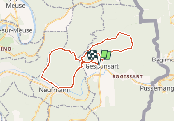
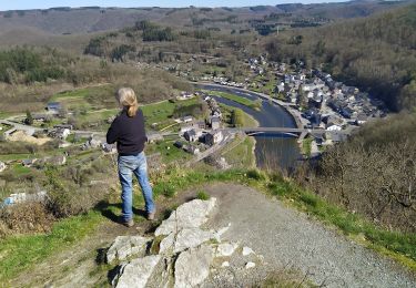
Tour Mountainbike von 15,2 km verfügbar auf Großer Osten, Ardennes, Gespunsart. Diese Tour wird von tracegps vorgeschlagen.
Beschreibung
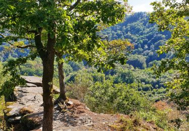
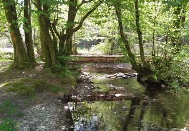
Boucle surtout dans les bois. Bons chemins en général. Petits passages de montée ardue. Difficulté selon météo. Démarrage à l'église de Gesponsart ou à Neufmanil (aux terrains de pétanque).
Ort
Land:
France
Region :
Großer Osten
Abteilung/Provinz :
Ardennes
Kommune :
Gespunsart
Standort:
Unknown
Gehen Sie:(Dec)
Gehen Sie:(UTM)
631447 ; 5520374 (31U) N.
Kommentare
Touren in der Umgebung
![Tour Wandern Vresse-sur-Semois - Bohan. Natura 2000, des sites qui valent le détour ! Na2 - Photo](https://media.geolcdn.com/t/375/260/ext.jpg?maxdim=2&url=https%3A%2F%2Fservices.sitytrail.com%2FGeolivesWS%2FDownloadMedia.ashx%3FTrailID%3D161427%26Media%3D5b0af75e-f56d-4b09-8a76-627d51a6ce1b.JPG)
![Wandern Wandern](https://static1.geolcdn.com/sitytour/trail-icons/101.png)
Bohan. Natura 2000, des sites qui valent le détour ! Na2
Wandern
Einfach
(1)
Vresse-sur-Semois,
Wallonien,
Namur,
Belgium
![](/images/other/stat-length.png)
4,8 km | 7,8 km-effort
1h 41min
![](https://static1.geolcdn.com/siteimages/upload/files/16400158638029165_repeat_loop_refresh_sync_direction_icon.png)
Ja
![Tour Wandern Haulmé - Thilay - Haulmé - Navaux - Photo](https://media.geolcdn.com/t/375/260/ext.jpg?maxdim=2&url=https%3A%2F%2Fservices.sitytrail.com%2FGeolivesWS%2FDownloadMedia.ashx%3FTrailID%3D214837%26Media%3D15355_6.jpg)
![Wandern Wandern](https://static1.geolcdn.com/sitytour/trail-icons/101.png)
Thilay - Haulmé - Navaux
Wandern
Medium
(3)
Haulmé,
Großer Osten,
Ardennes,
France
![](/images/other/stat-length.png)
15,3 km | 21 km-effort
3h 15min
![](https://static1.geolcdn.com/siteimages/upload/files/16400158638029165_repeat_loop_refresh_sync_direction_icon.png)
Ja
![Tour Wandern Nouzonville - Rando. Nouzonville FFSP - Photo](https://media.geolcdn.com/t/375/260/ext.jpg?maxdim=2&url=https%3A%2F%2Fservices.sitytrail.com%2FGeolivesWS%2FDownloadMedia.ashx%3FTrailID%3D756986%26Media%3D20170521131908.jpg)
![Wandern Wandern](https://static1.geolcdn.com/sitytour/trail-icons/101.png)
Rando. Nouzonville FFSP
Wandern
Medium
(1)
Nouzonville,
Großer Osten,
Ardennes,
France
![](/images/other/stat-length.png)
15,9 km | 21 km-effort
3h 55min
![](https://static1.geolcdn.com/siteimages/upload/files/16400158638029165_repeat_loop_refresh_sync_direction_icon.png)
Ja
![Wandern Wandern](https://static1.geolcdn.com/sitytour/trail-icons/101.png)
Promenade de la Croix - Bohan
Wandern
Medium
(1)
Vresse-sur-Semois,
Wallonien,
Namur,
Belgium
![](/images/other/stat-length.png)
5,2 km | 8,3 km-effort
2h 57min
![](https://static1.geolcdn.com/siteimages/upload/files/16400158638029165_repeat_loop_refresh_sync_direction_icon.png)
Ja
![Tour Wandern Vresse-sur-Semois - Promenade de la Table des Fées à Bohan - Photo](https://media.geolcdn.com/t/375/260/60ef2e5c-f3fa-416c-a603-6417ffcdf58a.jpeg&format=jpg&maxdim=2)
![Wandern Wandern](https://static1.geolcdn.com/sitytour/trail-icons/101.png)
Promenade de la Table des Fées à Bohan
Wandern
Medium
(1)
Vresse-sur-Semois,
Wallonien,
Namur,
Belgium
![](/images/other/stat-length.png)
4,8 km | 6,8 km-effort
2h 59min
![](https://static1.geolcdn.com/siteimages/upload/files/16400158638029165_repeat_loop_refresh_sync_direction_icon.png)
Ja
![Tour Zu Fuß Vresse-sur-Semois - La Vallée des baraques - Photo](https://media.geolcdn.com/t/375/260/ext.jpg?maxdim=2&url=https%3A%2F%2Fpivotmedia.tourismewallonie.be%2FOTH-A0-0058-0K6V%2FOTH-A0-0058-0K6V.jpg)
![Zu Fuß Zu Fuß](https://static1.geolcdn.com/sitytour/trail-icons/100.png)
La Vallée des baraques
Zu Fuß
Einfach
Vresse-sur-Semois,
Wallonien,
Namur,
Belgium
![](/images/other/stat-length.png)
11,4 km | 17,1 km-effort
3h 52min
![](https://static1.geolcdn.com/siteimages/upload/files/16400158638029165_repeat_loop_refresh_sync_direction_icon.png)
Ja
![Tour Zu Fuß Vresse-sur-Semois - Le vera - Photo](https://media.geolcdn.com/t/375/260/ext.jpg?maxdim=2&url=https%3A%2F%2Fpivotmedia.tourismewallonie.be%2FOTH-A0-0069-3HF2%2FOTH-A0-0069-3HF2.jpg)
![Zu Fuß Zu Fuß](https://static1.geolcdn.com/sitytour/trail-icons/100.png)
Le vera
Zu Fuß
Einfach
Vresse-sur-Semois,
Wallonien,
Namur,
Belgium
![](/images/other/stat-length.png)
4 km | 7,1 km-effort
1h 36min
![](https://static1.geolcdn.com/siteimages/upload/files/16400158638029165_repeat_loop_refresh_sync_direction_icon.png)
Ja
![Tour Zu Fuß Vresse-sur-Semois - La Croix - Photo](https://media.geolcdn.com/t/375/260/ext.jpg?maxdim=2&url=https%3A%2F%2Fpivotmedia.tourismewallonie.be%2FOTH-A0-0069-3GE0%2FOTH-A0-0069-3GE0.jpg)
![Zu Fuß Zu Fuß](https://static1.geolcdn.com/sitytour/trail-icons/100.png)
La Croix
Zu Fuß
Einfach
Vresse-sur-Semois,
Wallonien,
Namur,
Belgium
![](/images/other/stat-length.png)
4,9 km | 7,9 km-effort
1h 48min
![](https://static1.geolcdn.com/siteimages/upload/files/16400158638029165_repeat_loop_refresh_sync_direction_icon.png)
Ja
![Tour Zu Fuß Vresse-sur-Semois - Les dolimarts - Photo](https://media.geolcdn.com/t/375/260/ext.jpg?maxdim=2&url=https%3A%2F%2Fpivotmedia.tourismewallonie.be%2FOTH-A0-005T-1NO4%2FOTH-A0-005T-1NO4.jpg)
![Zu Fuß Zu Fuß](https://static1.geolcdn.com/sitytour/trail-icons/100.png)
Les dolimarts
Zu Fuß
Einfach
Vresse-sur-Semois,
Wallonien,
Namur,
Belgium
![](/images/other/stat-length.png)
4,2 km | 6,4 km-effort
1h 27min
![](https://static1.geolcdn.com/siteimages/upload/files/16400158638029165_repeat_loop_refresh_sync_direction_icon.png)
Ja