![](/images/other/stat-length.png)
![Tour Wandern Vacheresse - Traversée de la Pointe de Bénevent, Lac de Darbon - Photo](https://media.geolcdn.com/t/1900/400/ext.pjpeg?maxdim=2&url=https%3A%2F%2Fservices.sitytrail.com%2FGeolivesWS%2FDownloadMedia.ashx%3FTrailID%3D172583%26Media%3D13950_1.jpg)
Traversée de la Pointe de Bénevent, Lac de Darbon
tracegps
Benutzer
![Länge](/images/other/stat-length.png)
![Maximale Höhe](https://static1.geolcdn.com/siteimages/upload/files/1508320355ic_sort_altitude_max_24dp.png)
![Positive Höhendifferenz](https://static1.geolcdn.com/siteimages/upload/files/1508320355ic_sort_den_pos_24dp.png)
![Km-Effort](/images/other/stat-length.png)
![Min. Höhe](https://static1.geolcdn.com/siteimages/upload/files/1508320355ic_sort_altitude_min_24dp.png)
![Negative Höhendifferenz](https://static1.geolcdn.com/siteimages/upload/files/1508320355ic_sort_den_neg_24dp.png)
![Boucle](https://static1.geolcdn.com/siteimages/upload/files/16400158638029165_repeat_loop_refresh_sync_direction_icon.png)
![Wandern](https://static1.geolcdn.com/sitytour/trail-icons/101.png)
6h00
Schwierigkeit : Medium
![Scannen Sie diesen QR-Code, um die Tour in der SityTrail-Anwendung zu öffnen](https://capi.geolives.com/qq0zvz2zws4bq2lad0pu/sitytour/trails/172583/qr.png?size=200)
Kostenlosegpshiking-Anwendung
Über SityTrail
Tour Wandern von 12 km verfügbar auf Auvergne-Rhone-Alpen, Hochsavoyen, Vacheresse. Diese Tour wird von tracegps vorgeschlagen.
Beschreibung
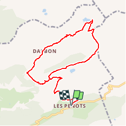
Chablais-Est Dent d'Oche-Bellevue. Sur la petite route des Chalets de Bise, le parking du Lac de Fontaine, situé au coeur d'un décor typique du Chablais est le point de départ d'une randonnée originale et très agréable. Pour monter jusqu'à la Bouaz, le sentier de la carte, disparu dans l'alpage, est remplacé par une piste en lacets. Plus haut, la Bouaz-Dessus est le départ d'un parcours de crête qui conduit par le Mont de Chillon à la Pointe de Bénevent. Le cheminement aérien se poursuit par la Pointe de Fire pour atteindre le Col de Floray, au pied des escarpements de la Pointe des Pavis. Une courte descente dépose au bord du Lac de Darbon au fond d'un cirque minéral exceptionnel dominé par le Château d'Oche. Un vallon agréable conduit aux chalets de Darbon, avant de rassembler ses forces pour 200 mètres de dénivelé positif qui ramène à la Bouaz-Dessus, et de là au point de départ. Description complète sur sentier-nature.com : Traversée de la Pointe de Bénevent, Lac de Darbon Avertissement [Exposition 1/3]. Certains passages de cet itinéraire de montagne sont escarpés et/ou très exposés, il est déconseillé aux enfants non accompagnés et aux personnes sujettes au vertige. Pour votre sécurité, nous vous invitons à respecter les règles suivantes : être bien chaussé, ne pas s'engager par mauvais temps, ne pas s'écarter de l'itinéraire ni des sentiers.
Ort
Kommentare
Touren in der Umgebung
![Tour Wandern Bernex - Dent d'Oche - coucher de soleil - Photo](https://media.geolcdn.com/t/375/260/ext.jpg?maxdim=2&url=https%3A%2F%2Fservices.sitytrail.com%2FGeolivesWS%2FDownloadMedia.ashx%3FTrailID%3D310307%26Media%3Dfix__20140607223141.jpg)
![Wandern Wandern](https://static1.geolcdn.com/sitytour/trail-icons/101.png)
Wandern
![](/images/other/stat-length.png)
![](https://static1.geolcdn.com/siteimages/upload/files/16400158638029165_repeat_loop_refresh_sync_direction_icon.png)
![Tour Wandern La Chapelle-d'Abondance - Les Cornettes de Bise par le sentier de Saix Rouquin - Photo](https://media.geolcdn.com/t/375/260/ext.jpg?maxdim=2&url=https%3A%2F%2Fservices.sitytrail.com%2FGeolivesWS%2FDownloadMedia.ashx%3FTrailID%3D107441%26Media%3D12359_1.jpg)
![Wandern Wandern](https://static1.geolcdn.com/sitytour/trail-icons/101.png)
Wandern
![](/images/other/stat-length.png)
![](https://static1.geolcdn.com/siteimages/upload/files/16400158638029165_repeat_loop_refresh_sync_direction_icon.png)
![Tour Wandern La Chapelle-d'Abondance - Cascade boucle 2 - Photo](https://media.geolcdn.com/t/375/260/ext.jpg?maxdim=2&url=https%3A%2F%2Fstatic1.geolcdn.com%2Fsiteimages%2Fupload%2Ffiles%2F1553511878bg_sport_marche.png)
![Wandern Wandern](https://static1.geolcdn.com/sitytour/trail-icons/101.png)
Wandern
![](/images/other/stat-length.png)
![](https://static1.geolcdn.com/siteimages/upload/files/16400158638029165_repeat_loop_refresh_sync_direction_icon.png)
![Tour Wandern La Chapelle-d'Abondance - lac darbon - Photo](https://media.geolcdn.com/t/375/260/ext.jpg?maxdim=2&url=https%3A%2F%2Fstatic1.geolcdn.com%2Fsiteimages%2Fupload%2Ffiles%2F1553511878bg_sport_marche.png)
![Wandern Wandern](https://static1.geolcdn.com/sitytour/trail-icons/101.png)
Wandern
![](/images/other/stat-length.png)
![](https://static1.geolcdn.com/siteimages/upload/files/16400158638029165_repeat_loop_refresh_sync_direction_icon.png)
![Tour Wandern La Chapelle-d'Abondance - Lac du Dacron - Photo](https://media.geolcdn.com/t/375/260/60be427f-9e1c-4b34-9c10-cd9ede0a30f2.jpg&format=jpg&maxdim=2)
![Wandern Wandern](https://static1.geolcdn.com/sitytour/trail-icons/101.png)
Wandern
![](/images/other/stat-length.png)
![](https://static1.geolcdn.com/siteimages/upload/files/16400158638029165_repeat_loop_refresh_sync_direction_icon.png)
![Tour Wandern Bernex - DENT D'OCHE ET LAC D'ARBON - Photo](https://media.geolcdn.com/t/375/260/9f9c1e84-a408-45e1-b0fa-60f5ada5bf93.jpg&format=jpg&maxdim=2)
![Wandern Wandern](https://static1.geolcdn.com/sitytour/trail-icons/101.png)
Wandern
![](/images/other/stat-length.png)
![](https://static1.geolcdn.com/siteimages/upload/files/16400158638029165_repeat_loop_refresh_sync_direction_icon.png)
![Tour Wandern Bernex - Boucle depuis Pre Richard.. - Photo](https://media.geolcdn.com/t/375/260/c7de377d-1993-4d05-b6af-1aa619f7194a.jpg&format=jpg&maxdim=2)
![Wandern Wandern](https://static1.geolcdn.com/sitytour/trail-icons/101.png)
Wandern
![](/images/other/stat-length.png)
![](https://static1.geolcdn.com/siteimages/upload/files/16400158638029165_repeat_loop_refresh_sync_direction_icon.png)
![Tour Wandern Vacheresse - Tour du Mont Chauffé - Photo](https://media.geolcdn.com/t/375/260/616d6b8c-2432-4c1f-8d15-d97066fc980f.jpg&format=jpg&maxdim=2)
![Wandern Wandern](https://static1.geolcdn.com/sitytour/trail-icons/101.png)
Wandern
![](/images/other/stat-length.png)
![](https://static1.geolcdn.com/siteimages/upload/files/16400158638029165_repeat_loop_refresh_sync_direction_icon.png)
![Tour Wandern La Chapelle-d'Abondance - CORNETTES DE BISE: LAC DE DARBON - Photo](https://media.geolcdn.com/t/375/260/0d7f20d8-223e-4e41-988a-3fb61b51b0c5.jpg&format=jpg&maxdim=2)
![Wandern Wandern](https://static1.geolcdn.com/sitytour/trail-icons/101.png)
Wandern
![](/images/other/stat-length.png)
![](https://static1.geolcdn.com/siteimages/upload/files/16400158638029165_repeat_loop_refresh_sync_direction_icon.png)