![](/images/other/stat-length.png)
![Tour Mountainbike Pont-d'Ouilly - La Goubinière - Le Bourg d'Ouilly - Photo](https://media.geolcdn.com/t/1900/400/ext.pjpeg?maxdim=2&url=https%3A%2F%2Fservices.sitytrail.com%2FGeolivesWS%2FDownloadMedia.ashx%3FTrailID%3D172518%26Media%3D13877_2.jpg)
La Goubinière - Le Bourg d'Ouilly
tracegps
Benutzer
![Länge](/images/other/stat-length.png)
![Maximale Höhe](https://static1.geolcdn.com/siteimages/upload/files/1508320355ic_sort_altitude_max_24dp.png)
![Positive Höhendifferenz](https://static1.geolcdn.com/siteimages/upload/files/1508320355ic_sort_den_pos_24dp.png)
![Km-Effort](/images/other/stat-length.png)
![Min. Höhe](https://static1.geolcdn.com/siteimages/upload/files/1508320355ic_sort_altitude_min_24dp.png)
![Negative Höhendifferenz](https://static1.geolcdn.com/siteimages/upload/files/1508320355ic_sort_den_neg_24dp.png)
![Boucle](https://static1.geolcdn.com/siteimages/upload/files/16400158638029165_repeat_loop_refresh_sync_direction_icon.png)
![Mountainbike](https://static1.geolcdn.com/sitytour/trail-icons/202.png)
4h30
Schwierigkeit : Schwierig
![Scannen Sie diesen QR-Code, um die Tour in der SityTrail-Anwendung zu öffnen](https://capi.geolives.com/qq0zvz2zws4bq2lad0pu/sitytour/trails/172518/qr.png?size=200)
Kostenlosegpshiking-Anwendung
Über SityTrail
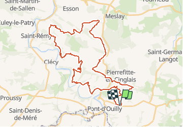
Tour Mountainbike von 44 km verfügbar auf Normandie, Calvados, Pont-d'Ouilly. Diese Tour wird von tracegps vorgeschlagen.
Beschreibung
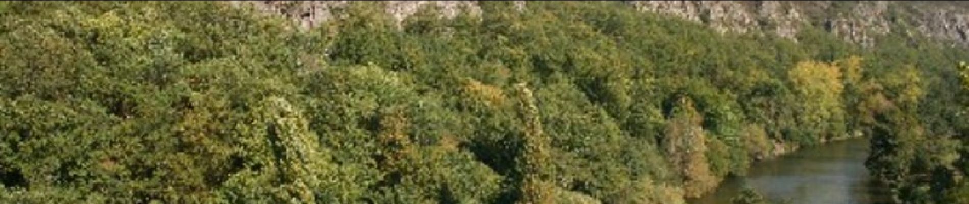
Au départ du Silo du Bourg d'Ouilly vous roulerez en Suisse Normande dans une vallée le long d'un ruisseau, vous descendrez un pierrier, vous allez aussi faire les Rochers des Parcs super point de vue sur la vallée de l'Orne. Je suis sûr que vous allez passer un bon moment.
Ort
Kommentare
Touren in der Umgebung
![Tour Mountainbike Pont-d'Ouilly - La Petite Suisse Normande 2014 - Pont-d'Ouilly - Photo](https://media.geolcdn.com/t/375/260/ext.jpg?maxdim=2&url=https%3A%2F%2Fservices.sitytrail.com%2FGeolivesWS%2FDownloadMedia.ashx%3FTrailID%3D317875%26Media%3D17266_3.jpg)
![Mountainbike Mountainbike](https://static1.geolcdn.com/sitytour/trail-icons/202.png)
Mountainbike
![](/images/other/stat-length.png)
![](https://static1.geolcdn.com/siteimages/upload/files/16400158638029165_repeat_loop_refresh_sync_direction_icon.png)
![Tour Wandern Ménil-Hubert-sur-Orne - De Rouvroy aux Roches d'Oetre par le sentier des Méandres - Photo](https://media.geolcdn.com/t/375/260/21e229b0-b429-4d44-ac88-f06ccf36f81a.jpg&format=jpg&maxdim=2)
![Wandern Wandern](https://static1.geolcdn.com/sitytour/trail-icons/101.png)
Wandern
![](/images/other/stat-length.png)
![](https://static1.geolcdn.com/siteimages/upload/files/16400158638029165_repeat_loop_refresh_sync_direction_icon.png)
![Tour Zu Fuß Saint-Philbert-sur-Orne - Entre Orne et Rouvre - Photo](https://media.geolcdn.com/t/375/260/baf151c8-29ed-422f-88ef-be9c392d457c.jpeg&format=jpg&maxdim=2)
![Zu Fuß Zu Fuß](https://static1.geolcdn.com/sitytour/trail-icons/100.png)
Zu Fuß
![](/images/other/stat-length.png)
![](https://static1.geolcdn.com/siteimages/upload/files/16400158638029165_repeat_loop_refresh_sync_direction_icon.png)
![Tour Zu Fuß Pont-d'Ouilly - Circuit du Val la Hère - Photo](https://media.geolcdn.com/t/375/260/6866eec6-8363-469e-b7f8-a0f7057e217e.jpeg&format=jpg&maxdim=2)
![Zu Fuß Zu Fuß](https://static1.geolcdn.com/sitytour/trail-icons/100.png)
Zu Fuß
![](/images/other/stat-length.png)
![](https://static1.geolcdn.com/siteimages/upload/files/16400158638029165_repeat_loop_refresh_sync_direction_icon.png)
![Tour Zu Fuß Le Bô - Des Montagnes de Normandie? - Photo](https://media.geolcdn.com/t/375/260/99446ac7-841c-43b2-a8d0-7ad8496245d0.jpeg&format=jpg&maxdim=2)
![Zu Fuß Zu Fuß](https://static1.geolcdn.com/sitytour/trail-icons/100.png)
Zu Fuß
![](/images/other/stat-length.png)
![](https://static1.geolcdn.com/siteimages/upload/files/16400158638029165_repeat_loop_refresh_sync_direction_icon.png)
![Tour Zu Fuß La Pommeraye - Les Rochers de Briesvieille - Photo](https://media.geolcdn.com/t/375/260/99446ac7-841c-43b2-a8d0-7ad8496245d0.jpeg&format=jpg&maxdim=2)
![Zu Fuß Zu Fuß](https://static1.geolcdn.com/sitytour/trail-icons/100.png)
Zu Fuß
![](/images/other/stat-length.png)
![](https://static1.geolcdn.com/siteimages/upload/files/16400158638029165_repeat_loop_refresh_sync_direction_icon.png)
![Tour Zu Fuß Le Bô - Le Moulin à Papier - Photo](https://media.geolcdn.com/t/375/260/3ac248d0-9006-472c-b1a7-3308f2fe9984.jpeg&format=jpg&maxdim=2)
![Zu Fuß Zu Fuß](https://static1.geolcdn.com/sitytour/trail-icons/100.png)
Zu Fuß
![](/images/other/stat-length.png)
![](https://static1.geolcdn.com/siteimages/upload/files/16400158638029165_repeat_loop_refresh_sync_direction_icon.png)
![Tour Zu Fuß Ménil-Vin - Circuit des Saulces - Photo](https://media.geolcdn.com/t/375/260/45025822-b146-462d-9ef7-870d47d30afc.jpeg&format=jpg&maxdim=2)
![Zu Fuß Zu Fuß](https://static1.geolcdn.com/sitytour/trail-icons/100.png)
Zu Fuß
![](/images/other/stat-length.png)
![](https://static1.geolcdn.com/siteimages/upload/files/16400158638029165_repeat_loop_refresh_sync_direction_icon.png)
![Tour Zu Fuß Le Mesnil-Villement - Tour du Pays de Falaise - Photo](https://media.geolcdn.com/t/375/260/eb7d45e9-9878-4c1f-b271-825b982670d4.jpeg&format=jpg&maxdim=2)
![Zu Fuß Zu Fuß](https://static1.geolcdn.com/sitytour/trail-icons/100.png)
Zu Fuß
![](/images/other/stat-length.png)
![](https://static1.geolcdn.com/siteimages/upload/files/16400158638029165_repeat_loop_refresh_sync_direction_icon.png)