![](/images/other/stat-length.png)
![Tour Mountainbike Arzon - De Arzon à la Pointe de St Jacques - Photo](https://media.geolcdn.com/t/1900/400/ext.pjpeg?maxdim=2&url=https%3A%2F%2Fservices.sitytrail.com%2FGeolivesWS%2FDownloadMedia.ashx%3FTrailID%3D172443%26Media%3D13794_1.jpg)
De Arzon à la Pointe de St Jacques
tracegps
Benutzer
![Länge](/images/other/stat-length.png)
Länge
28 km
![Maximale Höhe](https://static1.geolcdn.com/siteimages/upload/files/1508320355ic_sort_altitude_max_24dp.png)
Maximale Höhe
42 m
![Positive Höhendifferenz](https://static1.geolcdn.com/siteimages/upload/files/1508320355ic_sort_den_pos_24dp.png)
Positive Höhendifferenz
205 m
![Km-Effort](/images/other/stat-length.png)
Km-Effort
30 km
![Min. Höhe](https://static1.geolcdn.com/siteimages/upload/files/1508320355ic_sort_altitude_min_24dp.png)
Min. Höhe
0 m
![Negative Höhendifferenz](https://static1.geolcdn.com/siteimages/upload/files/1508320355ic_sort_den_neg_24dp.png)
Negative Höhendifferenz
206 m
![Boucle](https://static1.geolcdn.com/siteimages/upload/files/16400158638029165_repeat_loop_refresh_sync_direction_icon.png)
Boucle
Ja
Erstellungsdatum :
2014-12-10 00:00:00.0
Letzte Änderung :
2014-12-10 00:00:00.0
![Mountainbike](https://static1.geolcdn.com/sitytour/trail-icons/202.png)
2h00
Schwierigkeit : Medium
![Scannen Sie diesen QR-Code, um die Tour in der SityTrail-Anwendung zu öffnen](https://capi.geolives.com/qq0zvz2zws4bq2lad0pu/sitytour/trails/172443/qr.png?size=200)
Kostenlosegpshiking-Anwendung
Über SityTrail
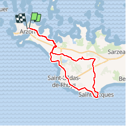
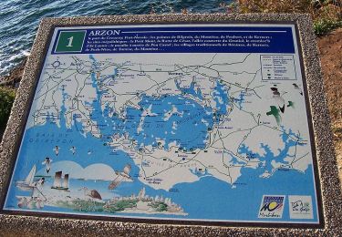
Tour Mountainbike von 28 km verfügbar auf Bretagne, Morbihan, Arzon. Diese Tour wird von tracegps vorgeschlagen.
Beschreibung
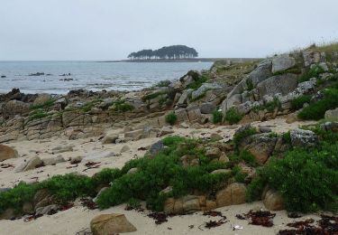
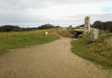
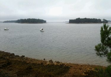
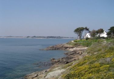
Circuit très agréable et familial sur la Presqu'Ile de Rhuys. Passage à la Pointe de St Jacques en bordure d'océan. Circuit en dehors de la circulation, chemin et petites routes avec pistes cyclables.
Ort
Land:
France
Region :
Bretagne
Abteilung/Provinz :
Morbihan
Kommune :
Arzon
Standort:
Unknown
Gehen Sie:(Dec)
Gehen Sie:(UTM)
508365 ; 5266317 (30T) N.
Kommentare
Touren in der Umgebung
![Tour Wandern Locmariaquer - PR_56_Locmariaquer_AA_01_Circuit1b_Entre-Golfe-Et-Ocean_20220217 - Photo](https://media.geolcdn.com/t/375/260/eee1e160-7ef6-4c8d-9c67-f23fbc97fcb6.jpg&format=jpg&maxdim=2)
![Wandern Wandern](https://static1.geolcdn.com/sitytour/trail-icons/101.png)
PR_56_Locmariaquer_AA_01_Circuit1b_Entre-Golfe-Et-Ocean_20220217
Wandern
Sehr leicht
(2)
Locmariaquer,
Bretagne,
Morbihan,
France
![](/images/other/stat-length.png)
8,5 km | 9,3 km-effort
1h 54min
![](https://static1.geolcdn.com/siteimages/upload/files/16400158638029165_repeat_loop_refresh_sync_direction_icon.png)
Ja
![Tour Wandern Locmariaquer - Locmariaquer et ses sites naturels - Photo](https://media.geolcdn.com/t/375/260/ext.jpg?maxdim=2&url=https%3A%2F%2Fservices.sitytrail.com%2FGeolivesWS%2FDownloadMedia.ashx%3FTrailID%3D316854%26Media%3D15924_5.jpg)
![Wandern Wandern](https://static1.geolcdn.com/sitytour/trail-icons/101.png)
Locmariaquer et ses sites naturels
Wandern
Medium
(1)
Locmariaquer,
Bretagne,
Morbihan,
France
![](/images/other/stat-length.png)
10,7 km | 11,4 km-effort
2h 45min
![](https://static1.geolcdn.com/siteimages/upload/files/16400158638029165_repeat_loop_refresh_sync_direction_icon.png)
Ja
![Tour Wandern Locmariaquer - Le tour de Locmariaquer - Photo](https://media.geolcdn.com/t/375/260/ext.jpg?maxdim=2&url=https%3A%2F%2Fservices.sitytrail.com%2FGeolivesWS%2FDownloadMedia.ashx%3FTrailID%3D316851%26Media%3D15920_6.jpg)
![Wandern Wandern](https://static1.geolcdn.com/sitytour/trail-icons/101.png)
Le tour de Locmariaquer
Wandern
Medium
(1)
Locmariaquer,
Bretagne,
Morbihan,
France
![](/images/other/stat-length.png)
8,4 km | 9,2 km-effort
2h 30min
![](https://static1.geolcdn.com/siteimages/upload/files/16400158638029165_repeat_loop_refresh_sync_direction_icon.png)
Ja
![Tour Wandern Locmariaquer - locmariaquer - Photo](https://media.geolcdn.com/t/375/260/ext.jpg?maxdim=2&url=https%3A%2F%2Fservices.sitytrail.com%2FGeolivesWS%2FDownloadMedia.ashx%3FTrailID%3D156625%26Media%3D20121004110915.jpeg)
![Wandern Wandern](https://static1.geolcdn.com/sitytour/trail-icons/101.png)
locmariaquer
Wandern
Einfach
(1)
Locmariaquer,
Bretagne,
Morbihan,
France
![](/images/other/stat-length.png)
7,2 km | 7,9 km-effort
1h 41min
![](https://static1.geolcdn.com/siteimages/upload/files/16400158638029165_repeat_loop_refresh_sync_direction_icon.png)
Ja
![Tour Wandern Locmariaquer - Raid du Golfe du Morbihan - Photo](https://media.geolcdn.com/t/375/260/ext.jpg?maxdim=2&url=https%3A%2F%2Fservices.sitytrail.com%2FGeolivesWS%2FDownloadMedia.ashx%3FTrailID%3D109057%26Media%3D3072_3.jpg)
![Wandern Wandern](https://static1.geolcdn.com/sitytour/trail-icons/101.png)
Raid du Golfe du Morbihan
Wandern
Sehr schwierig
(2)
Locmariaquer,
Bretagne,
Morbihan,
France
![](/images/other/stat-length.png)
177 km | 199 km-effort
44h 0min
![](https://static1.geolcdn.com/siteimages/upload/files/16400158638029165_repeat_loop_refresh_sync_direction_icon.png)
Nein
![Tour Wandern Arzon - tour d'Arzon - Photo](https://media.geolcdn.com/t/375/260/8d2666dc-76b6-4531-82fb-267206fdbff7.jpg&format=jpg&maxdim=2)
![Wandern Wandern](https://static1.geolcdn.com/sitytour/trail-icons/101.png)
tour d'Arzon
Wandern
Einfach
(1)
Arzon,
Bretagne,
Morbihan,
France
![](/images/other/stat-length.png)
12,6 km | 14,1 km-effort
3h 19min
![](https://static1.geolcdn.com/siteimages/upload/files/16400158638029165_repeat_loop_refresh_sync_direction_icon.png)
Ja
![Tour Laufen Larmor-Baden - Larmor Baden - Photo](https://media.geolcdn.com/t/375/260/ext.jpg?maxdim=2&url=https%3A%2F%2Fservices.sitytrail.com%2FGeolivesWS%2FDownloadMedia.ashx%3FTrailID%3D224679%26Media%3Dfix__20131001111052.jpg)
![Laufen Laufen](https://static1.geolcdn.com/sitytour/trail-icons/103.png)
Larmor Baden
Laufen
Medium
(1)
Larmor-Baden,
Bretagne,
Morbihan,
France
![](/images/other/stat-length.png)
5 km | 5,6 km-effort
54min
![](https://static1.geolcdn.com/siteimages/upload/files/16400158638029165_repeat_loop_refresh_sync_direction_icon.png)
Ja
![Tour Wandern Arzon - Tour du Golfe du Morbihan - 01 - Arzon - Photo](https://media.geolcdn.com/t/375/260/ext.jpg?maxdim=2&url=https%3A%2F%2Fservices.sitytrail.com%2FGeolivesWS%2FDownloadMedia.ashx%3FTrailID%3D109031%26Media%3D2997_2.jpg)
![Wandern Wandern](https://static1.geolcdn.com/sitytour/trail-icons/101.png)
Tour du Golfe du Morbihan - 01 - Arzon
Wandern
Medium
(1)
Arzon,
Bretagne,
Morbihan,
France
![](/images/other/stat-length.png)
18,9 km | 21 km-effort
4h 0min
![](https://static1.geolcdn.com/siteimages/upload/files/16400158638029165_repeat_loop_refresh_sync_direction_icon.png)
Nein
![Tour Wandern Arzon - Tour du Golfe - Arzon - Photo](https://media.geolcdn.com/t/375/260/ext.jpg?maxdim=2&url=https%3A%2F%2Fservices.sitytrail.com%2FGeolivesWS%2FDownloadMedia.ashx%3FTrailID%3D107071%26Media%3D11890_2.jpg)
![Wandern Wandern](https://static1.geolcdn.com/sitytour/trail-icons/101.png)
Tour du Golfe - Arzon
Wandern
Medium
(1)
Arzon,
Bretagne,
Morbihan,
France
![](/images/other/stat-length.png)
18,2 km | 20 km-effort
4h 30min
![](https://static1.geolcdn.com/siteimages/upload/files/16400158638029165_repeat_loop_refresh_sync_direction_icon.png)
Ja