![](/images/other/stat-length.png)
![Tour Mountainbike Curgies - Balade sportive au départ de Curgies - Photo](https://media.geolcdn.com/t/1900/400/ext.pjpeg?maxdim=2&url=https%3A%2F%2Fstatic1.geolcdn.com%2Fsiteimages%2Fupload%2Ffiles%2F1524743154velo.jpg)
Balade sportive au départ de Curgies
tracegps
Benutzer
![Länge](/images/other/stat-length.png)
Länge
57 km
![Maximale Höhe](https://static1.geolcdn.com/siteimages/upload/files/1508320355ic_sort_altitude_max_24dp.png)
Maximale Höhe
124 m
![Positive Höhendifferenz](https://static1.geolcdn.com/siteimages/upload/files/1508320355ic_sort_den_pos_24dp.png)
Positive Höhendifferenz
644 m
![Km-Effort](/images/other/stat-length.png)
Km-Effort
66 km
![Min. Höhe](https://static1.geolcdn.com/siteimages/upload/files/1508320355ic_sort_altitude_min_24dp.png)
Min. Höhe
40 m
![Negative Höhendifferenz](https://static1.geolcdn.com/siteimages/upload/files/1508320355ic_sort_den_neg_24dp.png)
Negative Höhendifferenz
639 m
![Boucle](https://static1.geolcdn.com/siteimages/upload/files/16400158638029165_repeat_loop_refresh_sync_direction_icon.png)
Boucle
Ja
Erstellungsdatum :
2014-12-10 00:00:00.0
Letzte Änderung :
2014-12-10 00:00:00.0
![Mountainbike](https://static1.geolcdn.com/sitytour/trail-icons/202.png)
3h00
Schwierigkeit : Medium
![Scannen Sie diesen QR-Code, um die Tour in der SityTrail-Anwendung zu öffnen](https://capi.geolives.com/qq0zvz2zws4bq2lad0pu/sitytour/trails/172418/qr.png?size=200)
Kostenlosegpshiking-Anwendung
Über SityTrail
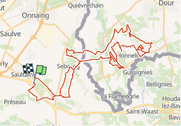
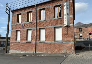
Tour Mountainbike von 57 km verfügbar auf Nordfrankreich, Nord, Curgies. Diese Tour wird von tracegps vorgeschlagen.
Beschreibung
Balade sportive au départ de Curgies en direction de la Belgique et plus particulièrement du caillou qui bique donc un peu de D .
Ort
Land:
France
Region :
Nordfrankreich
Abteilung/Provinz :
Nord
Kommune :
Curgies
Standort:
Unknown
Gehen Sie:(Dec)
Gehen Sie:(UTM)
542721 ; 5575407 (31U) N.
Kommentare
Touren in der Umgebung
![Tour Wandern Estreux - Balade à Estreux - Photo](https://media.geolcdn.com/t/375/260/ext.jpg?maxdim=2&url=https%3A%2F%2Fservices.sitytrail.com%2FGeolivesWS%2FDownloadMedia.ashx%3FTrailID%3D111675%26Media%3D7916_3.jpg)
![Wandern Wandern](https://static1.geolcdn.com/sitytour/trail-icons/101.png)
Balade à Estreux
Wandern
Medium
(1)
Estreux,
Nordfrankreich,
Nord,
France
![](/images/other/stat-length.png)
8,4 km | 9,4 km-effort
2h 10min
![](https://static1.geolcdn.com/siteimages/upload/files/16400158638029165_repeat_loop_refresh_sync_direction_icon.png)
Ja
![Tour Wandern Jenlain - Au départ de Jenlain - Photo](https://media.geolcdn.com/t/375/260/ext.jpg?maxdim=2&url=https%3A%2F%2Fservices.sitytrail.com%2FGeolivesWS%2FDownloadMedia.ashx%3FTrailID%3D109810%26Media%3D4753_5.jpg)
![Wandern Wandern](https://static1.geolcdn.com/sitytour/trail-icons/101.png)
Au départ de Jenlain
Wandern
Medium
(1)
Jenlain,
Nordfrankreich,
Nord,
France
![](/images/other/stat-length.png)
8,4 km | 9,7 km-effort
2h 10min
![](https://static1.geolcdn.com/siteimages/upload/files/16400158638029165_repeat_loop_refresh_sync_direction_icon.png)
Ja
![Tour Wandern Villers-Pol - Autour de Villers-Pol - Photo](https://media.geolcdn.com/t/375/260/ext.jpg?maxdim=2&url=https%3A%2F%2Fservices.sitytrail.com%2FGeolivesWS%2FDownloadMedia.ashx%3FTrailID%3D109837%26Media%3D4808_1.jpg)
![Wandern Wandern](https://static1.geolcdn.com/sitytour/trail-icons/101.png)
Autour de Villers-Pol
Wandern
Einfach
(2)
Villers-Pol,
Nordfrankreich,
Nord,
France
![](/images/other/stat-length.png)
7,7 km | 8,7 km-effort
1h 49min
![](https://static1.geolcdn.com/siteimages/upload/files/16400158638029165_repeat_loop_refresh_sync_direction_icon.png)
Ja
![Tour Wandern Jenlain - Jenlain 20,4 km - Photo](https://media.geolcdn.com/t/375/260/dc2d7a99-90ba-4862-8b09-aa142eac1f9a.jpg&format=jpg&maxdim=2)
![Wandern Wandern](https://static1.geolcdn.com/sitytour/trail-icons/101.png)
Jenlain 20,4 km
Wandern
Medium
Jenlain,
Nordfrankreich,
Nord,
France
![](/images/other/stat-length.png)
21 km | 24 km-effort
4h 54min
![](https://static1.geolcdn.com/siteimages/upload/files/16400158638029165_repeat_loop_refresh_sync_direction_icon.png)
Ja
![Tour Quad Sebourg - Sebourg - Photo](https://media.geolcdn.com/t/375/260/ext.jpg?maxdim=2&url=https%3A%2F%2Fstatic1.geolcdn.com%2Fsiteimages%2Fupload%2Ffiles%2F15247431544x4.jpg)
![Quad Quad](https://static1.geolcdn.com/sitytour/trail-icons/404.png)
Sebourg
Quad
Sehr leicht
(1)
Sebourg,
Nordfrankreich,
Nord,
France
![](/images/other/stat-length.png)
120 km | 133 km-effort
Unbekannt
![](https://static1.geolcdn.com/siteimages/upload/files/16400158638029165_repeat_loop_refresh_sync_direction_icon.png)
Ja
![Tour Wandern Sebourg - Le Bois de Sebourg - Photo](https://media.geolcdn.com/t/375/260/ext.jpg?maxdim=2&url=https%3A%2F%2Fstatic1.geolcdn.com%2Fsiteimages%2Fupload%2Ffiles%2F1553511878bg_sport_marche.png)
![Wandern Wandern](https://static1.geolcdn.com/sitytour/trail-icons/101.png)
Le Bois de Sebourg
Wandern
Sehr leicht
(1)
Sebourg,
Nordfrankreich,
Nord,
France
![](/images/other/stat-length.png)
6,6 km | 7,7 km-effort
1h 41min
![](https://static1.geolcdn.com/siteimages/upload/files/16400158638029165_repeat_loop_refresh_sync_direction_icon.png)
Ja
![Tour Wandern Wargnies-le-Grand - Jeanlain 15,3 km - Photo](https://media.geolcdn.com/t/375/260/08982edf-98b2-4314-9cbb-0950d8eb2fe7.jpg&format=jpg&maxdim=2)
![Wandern Wandern](https://static1.geolcdn.com/sitytour/trail-icons/101.png)
Jeanlain 15,3 km
Wandern
Einfach
Wargnies-le-Grand,
Nordfrankreich,
Nord,
France
![](/images/other/stat-length.png)
15,2 km | 17,6 km-effort
4h 12min
![](https://static1.geolcdn.com/siteimages/upload/files/16400158638029165_repeat_loop_refresh_sync_direction_icon.png)
Ja
![Tour Wandern Sebourg - Sebourg 17 km - Photo](https://media.geolcdn.com/t/375/260/cff1efdf-f2bc-4876-bf69-954ee818249f.jpg&format=jpg&maxdim=2)
![Wandern Wandern](https://static1.geolcdn.com/sitytour/trail-icons/101.png)
Sebourg 17 km
Wandern
Medium
Sebourg,
Nordfrankreich,
Nord,
France
![](/images/other/stat-length.png)
17 km | 19,8 km-effort
4h 37min
![](https://static1.geolcdn.com/siteimages/upload/files/16400158638029165_repeat_loop_refresh_sync_direction_icon.png)
Ja
![Tour Wandern Curgies - curgies, circuit des blockhaus - Photo](https://media.geolcdn.com/t/375/260/a10f8fb1-19b5-473a-b0ae-69ef8e04b648.jpg&format=jpg&maxdim=2)
![Wandern Wandern](https://static1.geolcdn.com/sitytour/trail-icons/101.png)
curgies, circuit des blockhaus
Wandern
Schwierig
Curgies,
Nordfrankreich,
Nord,
France
![](/images/other/stat-length.png)
11,6 km | 13 km-effort
2h 45min
![](https://static1.geolcdn.com/siteimages/upload/files/16400158638029165_repeat_loop_refresh_sync_direction_icon.png)
Ja