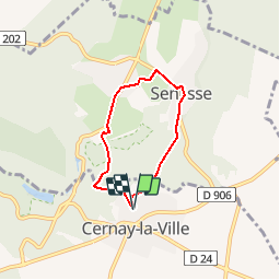
![](/images/other/stat-length.png)
![Tour Wandern Cernay-la-Ville - _Senlisse dans un écrin de verdure - Photo](https://media.geolcdn.com/t/1900/400/ext.pjpeg?maxdim=2&url=https%3A%2F%2Fservices.sitytrail.com%2FGeolivesWS%2FDownloadMedia.ashx%3FTrailID%3D172082%26Media%3D58eba867-baea-4143-80e9-e47f03036c03.jpg)
_Senlisse dans un écrin de verdure
Parc naturel régional de la Haute Vallée de Chevreuse
Randonnées du Parc naturel régional de la Haute Vallée de Chevreuse GUIDE+
![Länge](/images/other/stat-length.png)
![Maximale Höhe](https://static1.geolcdn.com/siteimages/upload/files/1508320355ic_sort_altitude_max_24dp.png)
![Positive Höhendifferenz](https://static1.geolcdn.com/siteimages/upload/files/1508320355ic_sort_den_pos_24dp.png)
![Km-Effort](/images/other/stat-length.png)
![Min. Höhe](https://static1.geolcdn.com/siteimages/upload/files/1508320355ic_sort_altitude_min_24dp.png)
![Negative Höhendifferenz](https://static1.geolcdn.com/siteimages/upload/files/1508320355ic_sort_den_neg_24dp.png)
![Boucle](https://static1.geolcdn.com/siteimages/upload/files/16400158638029165_repeat_loop_refresh_sync_direction_icon.png)
![Wandern](https://static1.geolcdn.com/sitytour/trail-icons/101.png)
1h30
Schwierigkeit : Einfach
![Scannen Sie diesen QR-Code, um die Tour in der SityTrail-Anwendung zu öffnen](https://capi.geolives.com/qq0zvz2zws4bq2lad0pu/sitytour/trails/172082/qr.png?size=200)
Kostenlosegpshiking-Anwendung
Über SityTrail
Tour Wandern von 4,5 km verfügbar auf Île-de-France, Yvelines, Cernay-la-Ville. Diese Tour wird von Parc naturel régional de la Haute Vallée de Chevreuse vorgeschlagen.
Beschreibung
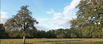
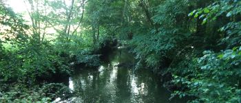
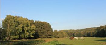
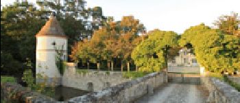
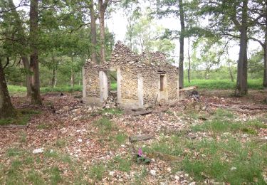
Au départ de Cernay-la-Ville, commune limitrophe, Senlisse dévoile une palette colorée de quiets paysages, du ru des Vaux à ses coteaux richement boisés. Heureux qui, comme à Senlisse, fit un beau voyage!
POIs
Ort
Kommentare
Touren in der Umgebung
![Tour Wandern Dampierre-en-Yvelines - _La Genèse - Photo](https://media.geolcdn.com/t/375/260/ext.jpg?maxdim=2&url=https%3A%2F%2Fservices.sitytrail.com%2FGeolivesWS%2FDownloadMedia.ashx%3FTrailID%3D746353%26Media%3D852eb799-755d-4473-ad2a-667c4a68a14c.jpg)
![Wandern Wandern](https://static1.geolcdn.com/sitytour/trail-icons/101.png)
Wandern
![](/images/other/stat-length.png)
![](https://static1.geolcdn.com/siteimages/upload/files/16400158638029165_repeat_loop_refresh_sync_direction_icon.png)
![Tour Wandern Dampierre-en-Yvelines - _Villages par mont et par vaux - Photo](https://media.geolcdn.com/t/375/260/ext.jpg?maxdim=2&url=https%3A%2F%2Fservices.sitytrail.com%2FGeolivesWS%2FDownloadMedia.ashx%3FTrailID%3D172084%26Media%3D1ba0ac7a-e5bc-4661-87da-e3aa68337b06.jpg)
![Wandern Wandern](https://static1.geolcdn.com/sitytour/trail-icons/101.png)
Wandern
![](/images/other/stat-length.png)
![](https://static1.geolcdn.com/siteimages/upload/files/16400158638029165_repeat_loop_refresh_sync_direction_icon.png)
![Tour Wandern La Celle-les-Bordes - _Sensations originelles - Photo](https://media.geolcdn.com/t/375/260/ext.jpg?maxdim=2&url=https%3A%2F%2Fservices.sitytrail.com%2FGeolivesWS%2FDownloadMedia.ashx%3FTrailID%3D172073%26Media%3D62ffcccf-49cf-426b-af31-a3cdff83876e.JPG)
![Wandern Wandern](https://static1.geolcdn.com/sitytour/trail-icons/101.png)
Wandern
![](/images/other/stat-length.png)
![](https://static1.geolcdn.com/siteimages/upload/files/16400158638029165_repeat_loop_refresh_sync_direction_icon.png)
![Tour Wandern Saint-Forget - _Saint-Forget, fief de Cyrano de Bergerac - Photo](https://media.geolcdn.com/t/375/260/ext.jpg?maxdim=2&url=https%3A%2F%2Fservices.sitytrail.com%2FGeolivesWS%2FDownloadMedia.ashx%3FTrailID%3D172086%26Media%3D7b590dd2-7d00-4099-a55f-664d59f11356.jpg)
![Wandern Wandern](https://static1.geolcdn.com/sitytour/trail-icons/101.png)
Wandern
![](/images/other/stat-length.png)
![](https://static1.geolcdn.com/siteimages/upload/files/16400158638029165_repeat_loop_refresh_sync_direction_icon.png)
![Tour Wandern Cernay-la-Ville - _Moulins des vaux de Cernay - Photo](https://media.geolcdn.com/t/375/260/ext.jpg?maxdim=2&url=https%3A%2F%2Fservices.sitytrail.com%2FGeolivesWS%2FDownloadMedia.ashx%3FTrailID%3D792341%26Media%3D9a8eb0df-2390-435a-866e-b0dd9677df49.JPG)
![Wandern Wandern](https://static1.geolcdn.com/sitytour/trail-icons/101.png)
Wandern
![](/images/other/stat-length.png)
![](https://static1.geolcdn.com/siteimages/upload/files/16400158638029165_repeat_loop_refresh_sync_direction_icon.png)
![Tour Wandern Chevreuse - _La balade de tous les plaisirs - Photo](https://media.geolcdn.com/t/375/260/ext.jpg?maxdim=2&url=https%3A%2F%2Fservices.sitytrail.com%2FGeolivesWS%2FDownloadMedia.ashx%3FTrailID%3D754966%26Media%3D761e5f27-0704-4761-a8b3-7fd3e291dd40.jpg)
![Wandern Wandern](https://static1.geolcdn.com/sitytour/trail-icons/101.png)
Wandern
![](/images/other/stat-length.png)
![](https://static1.geolcdn.com/siteimages/upload/files/16400158638029165_repeat_loop_refresh_sync_direction_icon.png)
![Tour Wandern Chevreuse - _Sur les pas de Racine (première partie) - Photo](https://media.geolcdn.com/t/375/260/ext.jpg?maxdim=2&url=https%3A%2F%2Fservices.sitytrail.com%2FGeolivesWS%2FDownloadMedia.ashx%3FTrailID%3D745166%26Media%3Dd5380f95-aa62-43a2-a37c-8510f53d593d.JPG)
![Wandern Wandern](https://static1.geolcdn.com/sitytour/trail-icons/101.png)
Wandern
![](/images/other/stat-length.png)
![](https://static1.geolcdn.com/siteimages/upload/files/16400158638029165_repeat_loop_refresh_sync_direction_icon.png)
![Tour Wandern Choisel - _Si Choisel m'était conté - Photo](https://media.geolcdn.com/t/375/260/ext.jpg?maxdim=2&url=https%3A%2F%2Fservices.sitytrail.com%2FGeolivesWS%2FDownloadMedia.ashx%3FTrailID%3D172083%26Media%3De60082f0-edf4-45f4-997a-35e9c7c799de.jpg)
![Wandern Wandern](https://static1.geolcdn.com/sitytour/trail-icons/101.png)
Wandern
![](/images/other/stat-length.png)
![](https://static1.geolcdn.com/siteimages/upload/files/16400158638029165_repeat_loop_refresh_sync_direction_icon.png)
![Tour Wandern Senlisse - _Sentier découverte des maréchaux - Photo](https://media.geolcdn.com/t/375/260/ext.jpg?maxdim=2&url=https%3A%2F%2Fservices.sitytrail.com%2FGeolivesWS%2FDownloadMedia.ashx%3FTrailID%3D792820%26Media%3D3d8a65e5-a46f-42a3-8cf9-3bcb3c260e3a.png)
![Wandern Wandern](https://static1.geolcdn.com/sitytour/trail-icons/101.png)
Wandern
![](/images/other/stat-length.png)
![](https://static1.geolcdn.com/siteimages/upload/files/16400158638029165_repeat_loop_refresh_sync_direction_icon.png)
tres sympa ce fait en 1h30
Quelques tronc d'arbre au tiers du parcours.Partie un peu dangereuse lorsque l'on doit longer une route après la ferme des Bouillons.
avec enfants : sympa hormis quelques passage sur une nationale fréquentée (possible passer sur le talus au dessus de la route), à faire par temps sec cause quelques passages très boueux
Parcours très sympa
A ne pas faire pas temps très humide. Une partie en milieu de parcours n'est pas praticable.
Belle balade
Excellent
Agréable et facile en fin de journée avec des enfants en bas âge
Randonnée sympathique. Attention, suite à de fortes pluies quelques jours avant, certains chemins en sous bois deviennent des ruisseaux de boue profonde impossibles à contourner.