![](/images/other/stat-length.png)
![Tour Wandern Lavalette - Laval de Nize - Photo](https://media.geolcdn.com/t/1900/400/ext.pjpeg?maxdim=2&url=https%3A%2F%2Fstatic1.geolcdn.com%2Fsiteimages%2Fupload%2Ffiles%2F1553511878bg_sport_marche.png)
Laval de Nize
jdelettrez
Benutzer
![Länge](/images/other/stat-length.png)
Länge
7,4 km
![Maximale Höhe](https://static1.geolcdn.com/siteimages/upload/files/1508320355ic_sort_altitude_max_24dp.png)
Maximale Höhe
615 m
![Positive Höhendifferenz](https://static1.geolcdn.com/siteimages/upload/files/1508320355ic_sort_den_pos_24dp.png)
Positive Höhendifferenz
285 m
![Km-Effort](/images/other/stat-length.png)
Km-Effort
11,2 km
![Min. Höhe](https://static1.geolcdn.com/siteimages/upload/files/1508320355ic_sort_altitude_min_24dp.png)
Min. Höhe
381 m
![Negative Höhendifferenz](https://static1.geolcdn.com/siteimages/upload/files/1508320355ic_sort_den_neg_24dp.png)
Negative Höhendifferenz
285 m
![Boucle](https://static1.geolcdn.com/siteimages/upload/files/16400158638029165_repeat_loop_refresh_sync_direction_icon.png)
Boucle
Ja
Erstellungsdatum :
2014-12-10 00:00:00.0
Letzte Änderung :
2014-12-10 00:00:00.0
![Wandern](https://static1.geolcdn.com/sitytour/trail-icons/101.png)
2h26
Schwierigkeit : Einfach
![Scannen Sie diesen QR-Code, um die Tour in der SityTrail-Anwendung zu öffnen](https://capi.geolives.com/qq0zvz2zws4bq2lad0pu/sitytour/trails/170229/qr.png?size=200)
Kostenlosegpshiking-Anwendung
Über SityTrail
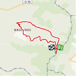
Tour Wandern von 7,4 km verfügbar auf Okzitanien, Hérault, Lavalette. Diese Tour wird von jdelettrez vorgeschlagen.
Beschreibung
La rando du Valde Nize depuis St Amans
PR Balisage en Jaune
Passage aux Briandes, descentes vers Laval de Nyse puis remonter en suivant le lit de la rivière.
Ne pas empreinter par temps d'orage...
Ort
Land:
France
Region :
Okzitanien
Abteilung/Provinz :
Hérault
Kommune :
Lavalette
Standort:
Unknown
Gehen Sie:(Dec)
Gehen Sie:(UTM)
520373 ; 4838036 (31T) N.
Kommentare
Touren in der Umgebung
![Tour Nordic Walking Olmet-et-Villecun - Villecun Lavalette - Photo](https://media.geolcdn.com/t/375/260/ff5dbcc8-7f6e-486e-b563-291aeb3db524.jpg&format=jpg&maxdim=2)
![Nordic Walking Nordic Walking](https://static1.geolcdn.com/sitytour/trail-icons/102.png)
Villecun Lavalette
Nordic Walking
Einfach
(1)
Olmet-et-Villecun,
Okzitanien,
Hérault,
France
![](/images/other/stat-length.png)
9,3 km | 12,4 km-effort
2h 13min
![](https://static1.geolcdn.com/siteimages/upload/files/16400158638029165_repeat_loop_refresh_sync_direction_icon.png)
Ja
![Tour Nordic Walking Joncels - RANDONNÉE JONCELS CIRCUIT ARCHÉOLOGIQUE - Photo](https://media.geolcdn.com/t/375/260/0eb6a312-d62e-40e4-973b-25f789da995e.png&format=jpg&maxdim=2)
![Nordic Walking Nordic Walking](https://static1.geolcdn.com/sitytour/trail-icons/102.png)
RANDONNÉE JONCELS CIRCUIT ARCHÉOLOGIQUE
Nordic Walking
Einfach
(1)
Joncels,
Okzitanien,
Hérault,
France
![](/images/other/stat-length.png)
8,9 km | 12 km-effort
2h 20min
![](https://static1.geolcdn.com/siteimages/upload/files/16400158638029165_repeat_loop_refresh_sync_direction_icon.png)
Ja
![Tour Wandern Lunas - RANDONNEE DE LAVAL DE NIZE - Photo](https://media.geolcdn.com/t/375/260/a871bb29-ae4b-4227-a102-498b734b8914.jpg&format=jpg&maxdim=2)
![Wandern Wandern](https://static1.geolcdn.com/sitytour/trail-icons/101.png)
RANDONNEE DE LAVAL DE NIZE
Wandern
Schwierig
(1)
Lunas,
Okzitanien,
Hérault,
France
![](/images/other/stat-length.png)
9,6 km | 13,7 km-effort
3h 7min
![](https://static1.geolcdn.com/siteimages/upload/files/16400158638029165_repeat_loop_refresh_sync_direction_icon.png)
Ja
![Tour Nordic Walking Lodève - Chemin des Tines - La Défriche - Belbezet - Montifort - Photo](https://media.geolcdn.com/t/375/260/5db620f0-9bce-46db-b4f7-036de46feabc.jpg&format=jpg&maxdim=2)
![Nordic Walking Nordic Walking](https://static1.geolcdn.com/sitytour/trail-icons/102.png)
Chemin des Tines - La Défriche - Belbezet - Montifort
Nordic Walking
Einfach
(1)
Lodève,
Okzitanien,
Hérault,
France
![](/images/other/stat-length.png)
8,3 km | 11,9 km-effort
Unbekannt
![](https://static1.geolcdn.com/siteimages/upload/files/16400158638029165_repeat_loop_refresh_sync_direction_icon.png)
Ja
![Tour Wandern Lodève - Saint-Martin - L'Ambeyran - Photo](https://media.geolcdn.com/t/375/260/ef8a520f-2d1e-48a3-a95d-ed76e0089665.jpg&format=jpg&maxdim=2)
![Wandern Wandern](https://static1.geolcdn.com/sitytour/trail-icons/101.png)
Saint-Martin - L'Ambeyran
Wandern
Medium
(1)
Lodève,
Okzitanien,
Hérault,
France
![](/images/other/stat-length.png)
9,4 km | 12,8 km-effort
2h 2min
![](https://static1.geolcdn.com/siteimages/upload/files/16400158638029165_repeat_loop_refresh_sync_direction_icon.png)
Ja
![Tour Wandern Octon - Octon (chapelle Notre Dame de Roubignac) - Photo](https://media.geolcdn.com/t/375/260/ext.jpg?maxdim=2&url=https%3A%2F%2Fstatic1.geolcdn.com%2Fsiteimages%2Fupload%2Ffiles%2F1553511878bg_sport_marche.png)
![Wandern Wandern](https://static1.geolcdn.com/sitytour/trail-icons/101.png)
Octon (chapelle Notre Dame de Roubignac)
Wandern
Einfach
(1)
Octon,
Okzitanien,
Hérault,
France
![](/images/other/stat-length.png)
14,7 km | 20 km-effort
5h 0min
![](https://static1.geolcdn.com/siteimages/upload/files/16400158638029165_repeat_loop_refresh_sync_direction_icon.png)
Ja
![Tour Wandern Octon - 34 octon ND roubignac - Photo](https://media.geolcdn.com/t/375/260/a9facb86-6434-4b9c-a347-c4531c44937d.jpg&format=jpg&maxdim=2)
![Wandern Wandern](https://static1.geolcdn.com/sitytour/trail-icons/101.png)
34 octon ND roubignac
Wandern
Einfach
Octon,
Okzitanien,
Hérault,
France
![](/images/other/stat-length.png)
14 km | 19,8 km-effort
5h 10min
![](https://static1.geolcdn.com/siteimages/upload/files/16400158638029165_repeat_loop_refresh_sync_direction_icon.png)
Nein
![Tour Mountainbike Octon - Octon 2017 - Photo](https://media.geolcdn.com/t/375/260/ext.jpg?maxdim=2&url=https%3A%2F%2Fstatic1.geolcdn.com%2Fsiteimages%2Fupload%2Ffiles%2F1524743154velo.jpg)
![Mountainbike Mountainbike](https://static1.geolcdn.com/sitytour/trail-icons/202.png)
Octon 2017
Mountainbike
Schwierig
(1)
Octon,
Okzitanien,
Hérault,
France
![](/images/other/stat-length.png)
37 km | 48 km-effort
3h 4min
![](https://static1.geolcdn.com/siteimages/upload/files/16400158638029165_repeat_loop_refresh_sync_direction_icon.png)
Ja
![Tour Wandern Octon - Octon - Chapelle ND de Roubignac et ruine château de Lauzières - Photo](https://media.geolcdn.com/t/375/260/d0bd2245-cad9-46e2-9b94-117da30f952c.jpg&format=jpg&maxdim=2)
![Wandern Wandern](https://static1.geolcdn.com/sitytour/trail-icons/101.png)
Octon - Chapelle ND de Roubignac et ruine château de Lauzières
Wandern
Medium
Octon,
Okzitanien,
Hérault,
France
![](/images/other/stat-length.png)
11,9 km | 15,9 km-effort
3h 3min
![](https://static1.geolcdn.com/siteimages/upload/files/16400158638029165_repeat_loop_refresh_sync_direction_icon.png)
Ja
ideal en ete