![](/images/other/stat-length.png)
![Tour Mountainbike Ostricourt - Autour d'Ostricourt - Photo](https://media.geolcdn.com/t/1900/400/ext.pjpeg?maxdim=2&url=https%3A%2F%2Fstatic1.geolcdn.com%2Fsiteimages%2Fupload%2Ffiles%2F1524743154velo.jpg)
Autour d'Ostricourt
scotte
Benutzer
![Länge](/images/other/stat-length.png)
Länge
63 km
![Maximale Höhe](https://static1.geolcdn.com/siteimages/upload/files/1508320355ic_sort_altitude_max_24dp.png)
Maximale Höhe
76 m
![Positive Höhendifferenz](https://static1.geolcdn.com/siteimages/upload/files/1508320355ic_sort_den_pos_24dp.png)
Positive Höhendifferenz
531 m
![Km-Effort](/images/other/stat-length.png)
Km-Effort
70 km
![Min. Höhe](https://static1.geolcdn.com/siteimages/upload/files/1508320355ic_sort_altitude_min_24dp.png)
Min. Höhe
19 m
![Negative Höhendifferenz](https://static1.geolcdn.com/siteimages/upload/files/1508320355ic_sort_den_neg_24dp.png)
Negative Höhendifferenz
531 m
![Boucle](https://static1.geolcdn.com/siteimages/upload/files/16400158638029165_repeat_loop_refresh_sync_direction_icon.png)
Boucle
Ja
Erstellungsdatum :
2014-12-10 00:00:00.0
Letzte Änderung :
2014-12-10 00:00:00.0
![Mountainbike](https://static1.geolcdn.com/sitytour/trail-icons/202.png)
4h00
Schwierigkeit : Medium
![Scannen Sie diesen QR-Code, um die Tour in der SityTrail-Anwendung zu öffnen](https://capi.geolives.com/qq0zvz2zws4bq2lad0pu/sitytour/trails/168007/qr.png?size=200)
Kostenlosegpshiking-Anwendung
Über SityTrail
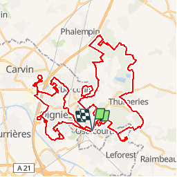
Tour Mountainbike von 63 km verfügbar auf Nordfrankreich, Nord, Ostricourt. Diese Tour wird von scotte vorgeschlagen.
Beschreibung
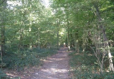
Balade sportive autour d'Ostricourt ralliant les terrils de Carvin, Le Forest et Ostricourt en passant par la forêt de Phalempin.
Ort
Land:
France
Region :
Nordfrankreich
Abteilung/Provinz :
Nord
Kommune :
Ostricourt
Standort:
Unknown
Gehen Sie:(Dec)
Gehen Sie:(UTM)
502173 ; 5589176 (31U) N.
Kommentare
Touren in der Umgebung
![Tour Wandern Mons-en-Pévèle - Autour du site ornithologique du bois des Cinq Tailles - Mons en Pévèle - Photo](https://media.geolcdn.com/t/375/260/ext.jpg?maxdim=2&url=https%3A%2F%2Fservices.sitytrail.com%2FGeolivesWS%2FDownloadMedia.ashx%3FTrailID%3D107326%26Media%3D12216_6.jpg)
![Wandern Wandern](https://static1.geolcdn.com/sitytour/trail-icons/101.png)
Autour du site ornithologique du bois des Cinq Tailles - Mons en Pévèle
Wandern
Medium
(4)
Mons-en-Pévèle,
Nordfrankreich,
Nord,
France
![](/images/other/stat-length.png)
11,2 km | 12,8 km-effort
2h 49min
![](https://static1.geolcdn.com/siteimages/upload/files/16400158638029165_repeat_loop_refresh_sync_direction_icon.png)
Ja
![Tour Wandern Libercourt - Rando 2 départ gare de Libercourt - Photo](https://media.geolcdn.com/t/375/260/6649baa4-bd92-471f-9e25-20f3b461a0d9.jpg&format=jpg&maxdim=2)
![Wandern Wandern](https://static1.geolcdn.com/sitytour/trail-icons/101.png)
Rando 2 départ gare de Libercourt
Wandern
Einfach
(1)
Libercourt,
Nordfrankreich,
Pas-de-Calais,
France
![](/images/other/stat-length.png)
13,1 km | 14,3 km-effort
2h 57min
![](https://static1.geolcdn.com/siteimages/upload/files/16400158638029165_repeat_loop_refresh_sync_direction_icon.png)
Ja
![Tour Wandern Libercourt - rando 1 départ gare de Libercourt - Photo](https://media.geolcdn.com/t/375/260/9962cfa6-bdeb-49c8-a4d4-8f0619f68da8.jpg&format=jpg&maxdim=2)
![Wandern Wandern](https://static1.geolcdn.com/sitytour/trail-icons/101.png)
rando 1 départ gare de Libercourt
Wandern
Einfach
(1)
Libercourt,
Nordfrankreich,
Pas-de-Calais,
France
![](/images/other/stat-length.png)
13,7 km | 15,2 km-effort
2h 57min
![](https://static1.geolcdn.com/siteimages/upload/files/16400158638029165_repeat_loop_refresh_sync_direction_icon.png)
Ja
![Tour Wandern Mons-en-Pévèle - le paradis de mons en pévèle - Photo](https://media.geolcdn.com/t/375/260/ext.jpg?maxdim=2&url=https%3A%2F%2Fstatic1.geolcdn.com%2Fsiteimages%2Fupload%2Ffiles%2F1553511878bg_sport_marche.png)
![Wandern Wandern](https://static1.geolcdn.com/sitytour/trail-icons/101.png)
le paradis de mons en pévèle
Wandern
Einfach
(1)
Mons-en-Pévèle,
Nordfrankreich,
Nord,
France
![](/images/other/stat-length.png)
8,6 km | 9,8 km-effort
2h 15min
![](https://static1.geolcdn.com/siteimages/upload/files/16400158638029165_repeat_loop_refresh_sync_direction_icon.png)
Ja
![Tour Wandern Auby - boucle des 3 cavaliers départ Auby - Photo](https://media.geolcdn.com/t/375/260/341a75ed-df9b-4e46-8149-070d6bbef0ed.jpg&format=jpg&maxdim=2)
![Wandern Wandern](https://static1.geolcdn.com/sitytour/trail-icons/101.png)
boucle des 3 cavaliers départ Auby
Wandern
Sehr schwierig
(1)
Auby,
Nordfrankreich,
Nord,
France
![](/images/other/stat-length.png)
23 km | 25 km-effort
6h 6min
![](https://static1.geolcdn.com/siteimages/upload/files/16400158638029165_repeat_loop_refresh_sync_direction_icon.png)
Ja
![Tour Wandern Auby - boucle Auby - Port d'eau Courcelles-lès-Lens - Photo](https://media.geolcdn.com/t/375/260/614df3b6-df05-46fc-8e4f-2f6cc2d5878b.jpg&format=jpg&maxdim=2)
![Wandern Wandern](https://static1.geolcdn.com/sitytour/trail-icons/101.png)
boucle Auby - Port d'eau Courcelles-lès-Lens
Wandern
Medium
Auby,
Nordfrankreich,
Nord,
France
![](/images/other/stat-length.png)
10,1 km | 10,8 km-effort
2h 10min
![](https://static1.geolcdn.com/siteimages/upload/files/16400158638029165_repeat_loop_refresh_sync_direction_icon.png)
Ja
![Tour Zu Fuß Oignies - oignies et le parc des hautois - Photo](https://media.geolcdn.com/t/375/260/ext.jpg?maxdim=2&url=https%3A%2F%2Fstatic1.geolcdn.com%2Fsiteimages%2Fupload%2Ffiles%2F1545311037marcheuse_200dpi.jpg)
![Zu Fuß Zu Fuß](https://static1.geolcdn.com/sitytour/trail-icons/100.png)
oignies et le parc des hautois
Zu Fuß
Medium
(1)
Oignies,
Nordfrankreich,
Pas-de-Calais,
France
![](/images/other/stat-length.png)
9,8 km | 11,1 km-effort
Unbekannt
![](https://static1.geolcdn.com/siteimages/upload/files/16400158638029165_repeat_loop_refresh_sync_direction_icon.png)
Ja
![Tour Nordic Walking Leforest - ostricourt - Photo](https://media.geolcdn.com/t/375/260/ext.jpg?maxdim=2&url=https%3A%2F%2Fstatic1.geolcdn.com%2Fsiteimages%2Fupload%2Ffiles%2F1545311037marcheuse_200dpi.jpg)
![Nordic Walking Nordic Walking](https://static1.geolcdn.com/sitytour/trail-icons/102.png)
ostricourt
Nordic Walking
Sehr leicht
(1)
Leforest,
Nordfrankreich,
Pas-de-Calais,
France
![](/images/other/stat-length.png)
6,6 km | 7,7 km-effort
1h 26min
![](https://static1.geolcdn.com/siteimages/upload/files/16400158638029165_repeat_loop_refresh_sync_direction_icon.png)
Ja
![Tour Wandern Mons-en-Pévèle - circuit des chapelles mons en pevele - Photo](https://media.geolcdn.com/t/375/260/ext.jpg?maxdim=2&url=https%3A%2F%2Fstatic1.geolcdn.com%2Fsiteimages%2Fupload%2Ffiles%2F1553511878bg_sport_marche.png)
![Wandern Wandern](https://static1.geolcdn.com/sitytour/trail-icons/101.png)
circuit des chapelles mons en pevele
Wandern
Medium
(4)
Mons-en-Pévèle,
Nordfrankreich,
Nord,
France
![](/images/other/stat-length.png)
13,3 km | 14,8 km-effort
3h 17min
![](https://static1.geolcdn.com/siteimages/upload/files/16400158638029165_repeat_loop_refresh_sync_direction_icon.png)
Ja