![](/images/other/stat-length.png)
![Tour Mountainbike Saint-Savournin - De St. savournin au mont St. Julien - Photo](https://media.geolcdn.com/t/1900/400/ext.pjpeg?maxdim=2&url=https%3A%2F%2Fservices.sitytrail.com%2FGeolivesWS%2FDownloadMedia.ashx%3FTrailID%3D167853%26Media%3D20121230125307.jpg)
De St. savournin au mont St. Julien
fifidebreizh
Benutzer
![Länge](/images/other/stat-length.png)
Länge
11,1 km
![Maximale Höhe](https://static1.geolcdn.com/siteimages/upload/files/1508320355ic_sort_altitude_max_24dp.png)
Maximale Höhe
532 m
![Positive Höhendifferenz](https://static1.geolcdn.com/siteimages/upload/files/1508320355ic_sort_den_pos_24dp.png)
Positive Höhendifferenz
241 m
![Km-Effort](/images/other/stat-length.png)
Km-Effort
14,3 km
![Min. Höhe](https://static1.geolcdn.com/siteimages/upload/files/1508320355ic_sort_altitude_min_24dp.png)
Min. Höhe
412 m
![Negative Höhendifferenz](https://static1.geolcdn.com/siteimages/upload/files/1508320355ic_sort_den_neg_24dp.png)
Negative Höhendifferenz
242 m
![Boucle](https://static1.geolcdn.com/siteimages/upload/files/16400158638029165_repeat_loop_refresh_sync_direction_icon.png)
Boucle
Ja
Erstellungsdatum :
2014-12-10 00:00:00.0
Letzte Änderung :
2014-12-10 00:00:00.0
![Mountainbike](https://static1.geolcdn.com/sitytour/trail-icons/202.png)
1h25
Schwierigkeit : Einfach
![Scannen Sie diesen QR-Code, um die Tour in der SityTrail-Anwendung zu öffnen](https://capi.geolives.com/qq0zvz2zws4bq2lad0pu/sitytour/trails/167853/qr.png?size=200)
Kostenlosegpshiking-Anwendung
Über SityTrail
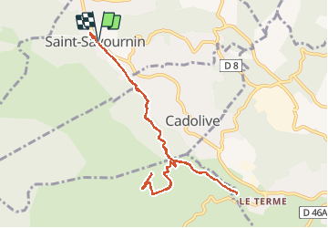
Tour Mountainbike von 11,1 km verfügbar auf Provence-Alpes-Côte d'Azur, Bouches-du-Rhône, Saint-Savournin. Diese Tour wird von fifidebreizh vorgeschlagen.
Beschreibung
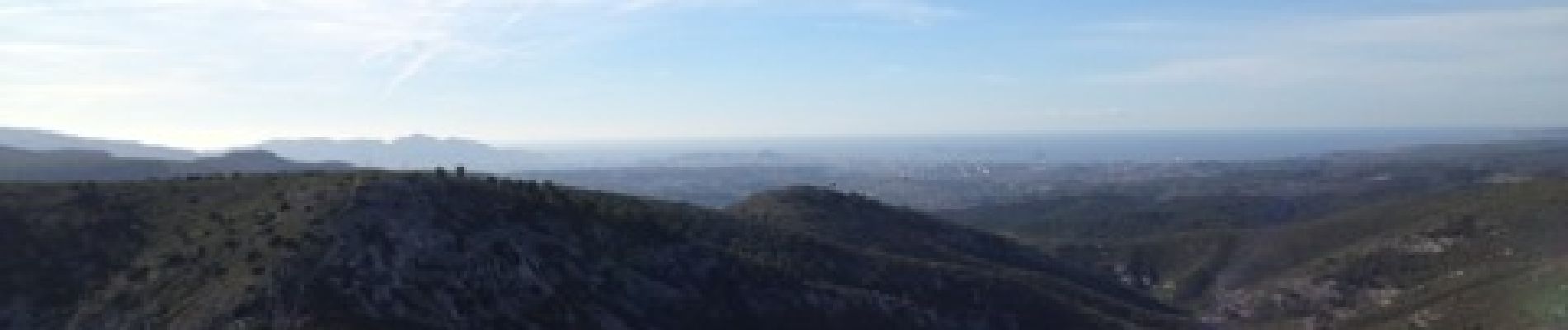
Première partie roulante, puis longue montée jusqu'au mont St. Julien. Beau panorama, d'un côté Marseille de l'autre la ste victoire. Descente roulante
Ort
Land:
France
Region :
Provence-Alpes-Côte d'Azur
Abteilung/Provinz :
Bouches-du-Rhône
Kommune :
Saint-Savournin
Standort:
Unknown
Gehen Sie:(Dec)
Gehen Sie:(UTM)
704706 ; 4809054 (31T) N.
Kommentare
Touren in der Umgebung
![Tour Wandern Allauch - SityTrail - le Pilon - Photo](https://media.geolcdn.com/t/375/260/f70c47ce-637e-4170-ac86-2a2a395feaa2.jpg&format=jpg&maxdim=2)
![Wandern Wandern](https://static1.geolcdn.com/sitytour/trail-icons/101.png)
SityTrail - le Pilon
Wandern
Medium
(1)
Allauch,
Provence-Alpes-Côte d'Azur,
Bouches-du-Rhône,
France
![](/images/other/stat-length.png)
13,7 km | 20 km-effort
6h 0min
![](https://static1.geolcdn.com/siteimages/upload/files/16400158638029165_repeat_loop_refresh_sync_direction_icon.png)
Ja
![Tour Wandern Allauch - Le tour des Grands Ubacs au départ de Pichauris - Photo](https://media.geolcdn.com/t/375/260/21675de2-6304-4cb6-a0f7-b5d15f62bb3e.jpg&format=jpg&maxdim=2)
![Wandern Wandern](https://static1.geolcdn.com/sitytour/trail-icons/101.png)
Le tour des Grands Ubacs au départ de Pichauris
Wandern
Einfach
(1)
Allauch,
Provence-Alpes-Côte d'Azur,
Bouches-du-Rhône,
France
![](/images/other/stat-length.png)
13,3 km | 20 km-effort
4h 25min
![](https://static1.geolcdn.com/siteimages/upload/files/16400158638029165_repeat_loop_refresh_sync_direction_icon.png)
Ja
![Tour Wandern Allauch - Domaine de Pichauris - Allauch - Photo](https://media.geolcdn.com/t/375/260/ext.jpg?maxdim=2&url=https%3A%2F%2Fservices.sitytrail.com%2FGeolivesWS%2FDownloadMedia.ashx%3FTrailID%3D103813%26Media%3D6587_1.jpg)
![Wandern Wandern](https://static1.geolcdn.com/sitytour/trail-icons/101.png)
Domaine de Pichauris - Allauch
Wandern
Medium
(1)
Allauch,
Provence-Alpes-Côte d'Azur,
Bouches-du-Rhône,
France
![](/images/other/stat-length.png)
10,5 km | 15 km-effort
2h 30min
![](https://static1.geolcdn.com/siteimages/upload/files/16400158638029165_repeat_loop_refresh_sync_direction_icon.png)
Ja
![Tour Wandern Allauch - le pic du Taoumé par Pichauris - Photo](https://media.geolcdn.com/t/375/260/6e9ae51a-41c8-431b-88f6-0e231e4db660.jpg&format=jpg&maxdim=2)
![Wandern Wandern](https://static1.geolcdn.com/sitytour/trail-icons/101.png)
le pic du Taoumé par Pichauris
Wandern
Einfach
Allauch,
Provence-Alpes-Côte d'Azur,
Bouches-du-Rhône,
France
![](/images/other/stat-length.png)
13,3 km | 20 km-effort
4h 32min
![](https://static1.geolcdn.com/siteimages/upload/files/16400158638029165_repeat_loop_refresh_sync_direction_icon.png)
Ja
![Tour Wandern Belcodène - La grotte du tonneau - Photo](https://media.geolcdn.com/t/375/260/7821dc69-cdc2-47ca-8a0e-3ea1f4ab4779.jpg&format=jpg&maxdim=2)
![Wandern Wandern](https://static1.geolcdn.com/sitytour/trail-icons/101.png)
La grotte du tonneau
Wandern
Schwierig
Belcodène,
Provence-Alpes-Côte d'Azur,
Bouches-du-Rhône,
France
![](/images/other/stat-length.png)
6,7 km | 9,5 km-effort
2h 20min
![](https://static1.geolcdn.com/siteimages/upload/files/16400158638029165_repeat_loop_refresh_sync_direction_icon.png)
Ja
![Tour Wandern Belcodène - la grotte du Tonneau avec escalades - Photo](https://media.geolcdn.com/t/375/260/51e2bffe-1872-4bae-84f1-b509d06dd0fa.jpg&format=jpg&maxdim=2)
![Wandern Wandern](https://static1.geolcdn.com/sitytour/trail-icons/101.png)
la grotte du Tonneau avec escalades
Wandern
Medium
(1)
Belcodène,
Provence-Alpes-Côte d'Azur,
Bouches-du-Rhône,
France
![](/images/other/stat-length.png)
9,7 km | 13,2 km-effort
6h 41min
![](https://static1.geolcdn.com/siteimages/upload/files/16400158638029165_repeat_loop_refresh_sync_direction_icon.png)
Ja
![Tour Mountainbike Allauch - les antennes du garlaban à modifier - Photo](https://media.geolcdn.com/t/375/260/b5861fec-07e7-4c16-8ca8-179e78ebdfae.jpg&format=jpg&maxdim=2)
![Mountainbike Mountainbike](https://static1.geolcdn.com/sitytour/trail-icons/202.png)
les antennes du garlaban à modifier
Mountainbike
Medium
Allauch,
Provence-Alpes-Côte d'Azur,
Bouches-du-Rhône,
France
![](/images/other/stat-length.png)
19,3 km | 28 km-effort
2h 8min
![](https://static1.geolcdn.com/siteimages/upload/files/16400158638029165_repeat_loop_refresh_sync_direction_icon.png)
Ja
![Tour Mountainbike Allauch - les antennes du garlaban - Photo](https://media.geolcdn.com/t/375/260/b5861fec-07e7-4c16-8ca8-179e78ebdfae.jpg&format=jpg&maxdim=2)
![Mountainbike Mountainbike](https://static1.geolcdn.com/sitytour/trail-icons/202.png)
les antennes du garlaban
Mountainbike
Medium
Allauch,
Provence-Alpes-Côte d'Azur,
Bouches-du-Rhône,
France
![](/images/other/stat-length.png)
19,3 km | 28 km-effort
2h 8min
![](https://static1.geolcdn.com/siteimages/upload/files/16400158638029165_repeat_loop_refresh_sync_direction_icon.png)
Ja
![Tour Mountainbike Allauch - de Pichauris au mont du Marseillais - Photo](https://media.geolcdn.com/t/375/260/ext.jpg?maxdim=2&url=https%3A%2F%2Fservices.sitytrail.com%2FGeolivesWS%2FDownloadMedia.ashx%3FTrailID%3D855696%26Media%3Dfix__20171101163219.jpg)
![Mountainbike Mountainbike](https://static1.geolcdn.com/sitytour/trail-icons/202.png)
de Pichauris au mont du Marseillais
Mountainbike
Medium
Allauch,
Provence-Alpes-Côte d'Azur,
Bouches-du-Rhône,
France
![](/images/other/stat-length.png)
14 km | 19,2 km-effort
2h 34min
![](https://static1.geolcdn.com/siteimages/upload/files/16400158638029165_repeat_loop_refresh_sync_direction_icon.png)
Ja