![](/images/other/stat-length.png)
![Tour Wandern Ternand - Forêt de Brou col des roches Blanches - Photo](https://media.geolcdn.com/t/1900/400/ext.pjpeg?maxdim=2&url=https%3A%2F%2Fstatic1.geolcdn.com%2Fsiteimages%2Fupload%2Ffiles%2F1553511878bg_sport_marche.png)
Forêt de Brou col des roches Blanches
picvert09
Benutzer
![Länge](/images/other/stat-length.png)
Länge
11,8 km
![Maximale Höhe](https://static1.geolcdn.com/siteimages/upload/files/1508320355ic_sort_altitude_max_24dp.png)
Maximale Höhe
750 m
![Positive Höhendifferenz](https://static1.geolcdn.com/siteimages/upload/files/1508320355ic_sort_den_pos_24dp.png)
Positive Höhendifferenz
558 m
![Km-Effort](/images/other/stat-length.png)
Km-Effort
19,3 km
![Min. Höhe](https://static1.geolcdn.com/siteimages/upload/files/1508320355ic_sort_altitude_min_24dp.png)
Min. Höhe
371 m
![Negative Höhendifferenz](https://static1.geolcdn.com/siteimages/upload/files/1508320355ic_sort_den_neg_24dp.png)
Negative Höhendifferenz
558 m
![Boucle](https://static1.geolcdn.com/siteimages/upload/files/16400158638029165_repeat_loop_refresh_sync_direction_icon.png)
Boucle
Ja
Erstellungsdatum :
2014-12-10 00:00:00.0
Letzte Änderung :
2014-12-10 00:00:00.0
![Wandern](https://static1.geolcdn.com/sitytour/trail-icons/101.png)
4h00
Schwierigkeit : Medium
![Scannen Sie diesen QR-Code, um die Tour in der SityTrail-Anwendung zu öffnen](https://capi.geolives.com/qq0zvz2zws4bq2lad0pu/sitytour/trails/163038/qr.png?size=200)
Kostenlosegpshiking-Anwendung
Über SityTrail
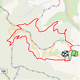
Tour Wandern von 11,8 km verfügbar auf Auvergne-Rhone-Alpen, Rhône, Ternand. Diese Tour wird von picvert09 vorgeschlagen.
Beschreibung
Un circuit qui démarre dans les vignes mais qui est majoritairement en forêt
Prévoir des chaussures de marches car beaucoup de cailloux sur les sentiers
Ort
Land:
France
Region :
Auvergne-Rhone-Alpen
Abteilung/Provinz :
Rhône
Kommune :
Ternand
Standort:
Unknown
Gehen Sie:(Dec)
Gehen Sie:(UTM)
617095 ; 5089439 (31T) N.
Kommentare
Touren in der Umgebung
![Tour Wandern Ternand - 2022-04-07_21h47m08_Ternand_V2 - Photo](https://media.geolcdn.com/t/375/260/d73b31f3-847d-4c86-9759-810d2e04500a.jpg&format=jpg&maxdim=2)
![Wandern Wandern](https://static1.geolcdn.com/sitytour/trail-icons/101.png)
2022-04-07_21h47m08_Ternand_V2
Wandern
Sehr schwierig
(1)
Ternand,
Auvergne-Rhone-Alpen,
Rhône,
France
![](/images/other/stat-length.png)
17,8 km | 27 km-effort
6h 7min
![](https://static1.geolcdn.com/siteimages/upload/files/16400158638029165_repeat_loop_refresh_sync_direction_icon.png)
Ja
![Tour Wandern Saint-Vérand - Saint Vérand - Photo](https://media.geolcdn.com/t/375/260/ext.jpg?maxdim=2&url=https%3A%2F%2Fstatic1.geolcdn.com%2Fsiteimages%2Fupload%2Ffiles%2F1553511878bg_sport_marche.png)
![Wandern Wandern](https://static1.geolcdn.com/sitytour/trail-icons/101.png)
Saint Vérand
Wandern
Medium
(1)
Saint-Vérand,
Auvergne-Rhone-Alpen,
Rhône,
France
![](/images/other/stat-length.png)
13,5 km | 21 km-effort
3h 37min
![](https://static1.geolcdn.com/siteimages/upload/files/16400158638029165_repeat_loop_refresh_sync_direction_icon.png)
Ja
![Tour Wandern Dième - Le Ruisseau de Brou - Photo](https://media.geolcdn.com/t/375/260/ext.jpg?maxdim=2&url=https%3A%2F%2Fstatic1.geolcdn.com%2Fsiteimages%2Fupload%2Ffiles%2F1553511878bg_sport_marche.png)
![Wandern Wandern](https://static1.geolcdn.com/sitytour/trail-icons/101.png)
Le Ruisseau de Brou
Wandern
Medium
(1)
Dième,
Auvergne-Rhone-Alpen,
Rhône,
France
![](/images/other/stat-length.png)
11,3 km | 17,3 km-effort
3h 24min
![](https://static1.geolcdn.com/siteimages/upload/files/16400158638029165_repeat_loop_refresh_sync_direction_icon.png)
Ja
![Tour Wandern Sainte-Paule - Sainte-Paule (13,4 km D. 485 m) - Photo](https://media.geolcdn.com/t/375/260/ext.jpg?maxdim=2&url=https%3A%2F%2Fstatic1.geolcdn.com%2Fsiteimages%2Fupload%2Ffiles%2F1553511878bg_sport_marche.png)
![Wandern Wandern](https://static1.geolcdn.com/sitytour/trail-icons/101.png)
Sainte-Paule (13,4 km D. 485 m)
Wandern
Medium
(1)
Sainte-Paule,
Auvergne-Rhone-Alpen,
Rhône,
France
![](/images/other/stat-length.png)
13,4 km | 19,4 km-effort
4h 9min
![](https://static1.geolcdn.com/siteimages/upload/files/16400158638029165_repeat_loop_refresh_sync_direction_icon.png)
Ja
![Tour Wandern Val d'Oingt - 69620-StLo-160412-Azergues+Genetière+Berthier - Photo](https://media.geolcdn.com/t/375/260/ext.jpg?maxdim=2&url=https%3A%2F%2Fstatic1.geolcdn.com%2Fsiteimages%2Fupload%2Ffiles%2F1553511878bg_sport_marche.png)
![Wandern Wandern](https://static1.geolcdn.com/sitytour/trail-icons/101.png)
69620-StLo-160412-Azergues+Genetière+Berthier
Wandern
Einfach
(2)
Val d'Oingt,
Auvergne-Rhone-Alpen,
Rhône,
France
![](/images/other/stat-length.png)
5,2 km | 7,1 km-effort
1h 38min
![](https://static1.geolcdn.com/siteimages/upload/files/16400158638029165_repeat_loop_refresh_sync_direction_icon.png)
Ja
![Wandern Wandern](https://static1.geolcdn.com/sitytour/trail-icons/101.png)
Saint-Laurent d'Oingt - Oingt, Plus beau Village de France
Wandern
Schwierig
Val d'Oingt,
Auvergne-Rhone-Alpen,
Rhône,
France
![](/images/other/stat-length.png)
8,8 km | 12,5 km-effort
2h 20min
![](https://static1.geolcdn.com/siteimages/upload/files/16400158638029165_repeat_loop_refresh_sync_direction_icon.png)
Ja
![Tour Wandern Val d'Oingt - 69620-Saint-Laurent d'Oingt-Bois d'Oingt : lavoirs, château et coteaux - Photo](https://media.geolcdn.com/t/375/260/f3b7e635-4f2d-4ecb-b5c7-b81cf631e86a.jpg&format=jpg&maxdim=2)
![Wandern Wandern](https://static1.geolcdn.com/sitytour/trail-icons/101.png)
69620-Saint-Laurent d'Oingt-Bois d'Oingt : lavoirs, château et coteaux
Wandern
Medium
Val d'Oingt,
Auvergne-Rhone-Alpen,
Rhône,
France
![](/images/other/stat-length.png)
8 km | 11 km-effort
1h 57min
![](https://static1.geolcdn.com/siteimages/upload/files/16400158638029165_repeat_loop_refresh_sync_direction_icon.png)
Ja
![Tour Wandern Val d'Oingt - Trail & Rando de](https://media.geolcdn.com/t/375/260/e8df058e-c2da-4e2a-813f-f16a55ee167c.jpg&format=jpg&maxdim=2)
![Wandern Wandern](https://static1.geolcdn.com/sitytour/trail-icons/101.png)
Trail & Rando de "La Vigne en Rose"- 21 kms - 14/07/2021
Wandern
Sehr schwierig
Val d'Oingt,
Auvergne-Rhone-Alpen,
Rhône,
France
![](/images/other/stat-length.png)
22 km | 31 km-effort
5h 0min
![](https://static1.geolcdn.com/siteimages/upload/files/16400158638029165_repeat_loop_refresh_sync_direction_icon.png)
Ja
![Tour Wandern Val d'Oingt - Trail & Randonnée de](https://media.geolcdn.com/t/375/260/406a0e13-257c-4258-a483-9a6f9e3a17b6.jpg&format=jpg&maxdim=2)
![Wandern Wandern](https://static1.geolcdn.com/sitytour/trail-icons/101.png)
Trail & Randonnée de "La vigne en rose" - 11kms - 14 juillet 2021
Wandern
Schwierig
Val d'Oingt,
Auvergne-Rhone-Alpen,
Rhône,
France
![](/images/other/stat-length.png)
10,8 km | 14,5 km-effort
2h 55min
![](https://static1.geolcdn.com/siteimages/upload/files/16400158638029165_repeat_loop_refresh_sync_direction_icon.png)
Ja