![](/images/other/stat-length.png)
![Tour Mountainbike Gesves - La Gesvoise, 11-11-2012 - Photo](https://media.geolcdn.com/t/1900/400/ext.pjpeg?maxdim=2&url=https%3A%2F%2Fstatic1.geolcdn.com%2Fsiteimages%2Fupload%2Ffiles%2F1524743154velo.jpg)
La Gesvoise, 11-11-2012
dvandormael
Benutzer
![Länge](/images/other/stat-length.png)
Länge
26 km
![Maximale Höhe](https://static1.geolcdn.com/siteimages/upload/files/1508320355ic_sort_altitude_max_24dp.png)
Maximale Höhe
305 m
![Positive Höhendifferenz](https://static1.geolcdn.com/siteimages/upload/files/1508320355ic_sort_den_pos_24dp.png)
Positive Höhendifferenz
469 m
![Km-Effort](/images/other/stat-length.png)
Km-Effort
32 km
![Min. Höhe](https://static1.geolcdn.com/siteimages/upload/files/1508320355ic_sort_altitude_min_24dp.png)
Min. Höhe
205 m
![Negative Höhendifferenz](https://static1.geolcdn.com/siteimages/upload/files/1508320355ic_sort_den_neg_24dp.png)
Negative Höhendifferenz
471 m
![Boucle](https://static1.geolcdn.com/siteimages/upload/files/16400158638029165_repeat_loop_refresh_sync_direction_icon.png)
Boucle
Ja
Erstellungsdatum :
2014-12-10 00:00:00.0
Letzte Änderung :
2014-12-10 00:00:00.0
![Mountainbike](https://static1.geolcdn.com/sitytour/trail-icons/202.png)
2h04
Schwierigkeit : Unbekannt
![Scannen Sie diesen QR-Code, um die Tour in der SityTrail-Anwendung zu öffnen](https://capi.geolives.com/qq0zvz2zws4bq2lad0pu/sitytour/trails/162301/qr.png?size=200)
Kostenlosegpshiking-Anwendung
Über SityTrail
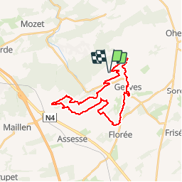
Tour Mountainbike von 26 km verfügbar auf Wallonien, Namur, Gesves. Diese Tour wird von dvandormael vorgeschlagen.
Beschreibung
Organisée par le VC Faulx-les-Tombes (http://sites.google.com/site/vclapedaleflt).
Doit être vraiment super par temps sec, mais un enfer s'il a plu (boueux, boueux, boueux !)
Ort
Land:
Belgium
Region :
Wallonien
Abteilung/Provinz :
Namur
Kommune :
Gesves
Standort:
Gesves
Gehen Sie:(Dec)
Gehen Sie:(UTM)
646339 ; 5586375 (31U) N.
Kommentare
Touren in der Umgebung
![Wandern Wandern](https://static1.geolcdn.com/sitytour/trail-icons/101.png)
Sentiers d'Art : Boucle 8 - Gesves
Wandern
Schwierig
(5)
Gesves,
Wallonien,
Namur,
Belgium
![](/images/other/stat-length.png)
12,6 km | 15,6 km-effort
3h 24min
![](https://static1.geolcdn.com/siteimages/upload/files/16400158638029165_repeat_loop_refresh_sync_direction_icon.png)
Ja
![Tour Wandern Gesves - RB-Na-01 Raccourci - Vallée du Samson en Condroz namurois - Photo](https://media.geolcdn.com/t/375/260/ext.jpg?maxdim=2&url=https%3A%2F%2Fservices.sitytrail.com%2FGeolivesWS%2FDownloadMedia.ashx%3FTrailID%3D213609%26Media%3D506f23b2-0581-4f03-b006-9ca575596278.jpg)
![Wandern Wandern](https://static1.geolcdn.com/sitytour/trail-icons/101.png)
RB-Na-01 Raccourci - Vallée du Samson en Condroz namurois
Wandern
Sehr schwierig
(15)
Gesves,
Wallonien,
Namur,
Belgium
![](/images/other/stat-length.png)
18,3 km | 25 km-effort
5h 34min
![](https://static1.geolcdn.com/siteimages/upload/files/16400158638029165_repeat_loop_refresh_sync_direction_icon.png)
Ja
![Tour Wandern Gesves - RB-Na-01 Vallée du Samson en Condroz namurois - Photo](https://media.geolcdn.com/t/375/260/ext.jpg?maxdim=2&url=https%3A%2F%2Fservices.sitytrail.com%2FGeolivesWS%2FDownloadMedia.ashx%3FTrailID%3D179626%26Media%3D506f23b2-0581-4f03-b006-9ca575596278.jpg)
![Wandern Wandern](https://static1.geolcdn.com/sitytour/trail-icons/101.png)
RB-Na-01 Vallée du Samson en Condroz namurois
Wandern
Sehr schwierig
(15)
Gesves,
Wallonien,
Namur,
Belgium
![](/images/other/stat-length.png)
25 km | 33 km-effort
7h 26min
![](https://static1.geolcdn.com/siteimages/upload/files/16400158638029165_repeat_loop_refresh_sync_direction_icon.png)
Ja
![Tour Wandern Andenne - GESVES- Goyet- n°08- Eau - Photo](https://media.geolcdn.com/t/375/260/ext.jpg?maxdim=2&url=https%3A%2F%2Fservices.sitytrail.com%2FGeolivesWS%2FDownloadMedia.ashx%3FTrailID%3D121402%26Media%3D624555aa-5d04-4964-8666-f3856017c3be.jpg)
![Wandern Wandern](https://static1.geolcdn.com/sitytour/trail-icons/101.png)
GESVES- Goyet- n°08- Eau
Wandern
Schwierig
(9)
Andenne,
Wallonien,
Namur,
Belgium
![](/images/other/stat-length.png)
9,1 km | 12,3 km-effort
2h 36min
![](https://static1.geolcdn.com/siteimages/upload/files/16400158638029165_repeat_loop_refresh_sync_direction_icon.png)
Ja
![Tour Wandern Gesves - GESVES- Le Pré D'Amite- N°07- Bois - Photo](https://media.geolcdn.com/t/375/260/ext.jpg?maxdim=2&url=https%3A%2F%2Fservices.sitytrail.com%2FGeolivesWS%2FDownloadMedia.ashx%3FTrailID%3D121401%26Media%3D56c27e3a-fec1-4804-be43-ac45373f04b7.jpg)
![Wandern Wandern](https://static1.geolcdn.com/sitytour/trail-icons/101.png)
GESVES- Le Pré D'Amite- N°07- Bois
Wandern
Schwierig
(13)
Gesves,
Wallonien,
Namur,
Belgium
![](/images/other/stat-length.png)
9,4 km | 12,5 km-effort
2h 41min
![](https://static1.geolcdn.com/siteimages/upload/files/16400158638029165_repeat_loop_refresh_sync_direction_icon.png)
Ja
![Tour Wandern Gesves - Sentiers d'art : Boucle 11- Haltinne - Photo](https://media.geolcdn.com/t/375/260/ext.jpg?maxdim=2&url=https%3A%2F%2Fservices.sitytrail.com%2FGeolivesWS%2FDownloadMedia.ashx%3FTrailID%3D993205%26Media%3D139263e1-20ce-42ae-8880-fc99e747d4c7.jpg)
![Wandern Wandern](https://static1.geolcdn.com/sitytour/trail-icons/101.png)
Sentiers d'art : Boucle 11- Haltinne
Wandern
Einfach
(6)
Gesves,
Wallonien,
Namur,
Belgium
![](/images/other/stat-length.png)
9,6 km | 11,8 km-effort
2h 0min
![](https://static1.geolcdn.com/siteimages/upload/files/16400158638029165_repeat_loop_refresh_sync_direction_icon.png)
Ja
![Tour Wandern Gesves - RF-Na-03-Goyet_Grande-boucle - Photo](https://media.geolcdn.com/t/375/260/ext.jpg?maxdim=2&url=https%3A%2F%2Fservices.sitytrail.com%2FGeolivesWS%2FDownloadMedia.ashx%3FTrailID%3D545745%26Media%3D72077e8d-e20a-4ee7-98f3-ad34263963e3.JPG)
![Wandern Wandern](https://static1.geolcdn.com/sitytour/trail-icons/101.png)
RF-Na-03-Goyet_Grande-boucle
Wandern
Medium
(5)
Gesves,
Wallonien,
Namur,
Belgium
![](/images/other/stat-length.png)
6,4 km | 8,9 km-effort
1h 54min
![](https://static1.geolcdn.com/siteimages/upload/files/16400158638029165_repeat_loop_refresh_sync_direction_icon.png)
Ja
![Wandern Wandern](https://static1.geolcdn.com/sitytour/trail-icons/101.png)
Promenade des Petits Ponts- Bois d'Ohey
Wandern
Medium
(9)
Ohey,
Wallonien,
Namur,
Belgium
![](/images/other/stat-length.png)
6,2 km | 7,4 km-effort
1h 38min
![](https://static1.geolcdn.com/siteimages/upload/files/16400158638029165_repeat_loop_refresh_sync_direction_icon.png)
Ja
![Wandern Wandern](https://static1.geolcdn.com/sitytour/trail-icons/101.png)
SENTIERS D'ART - Grande randonnée - Assesse, Ciney, Gesves, Hamois, Havelange...
Wandern
Sehr schwierig
(1)
Gesves,
Wallonien,
Namur,
Belgium
![](/images/other/stat-length.png)
155 km | 193 km-effort
43h 50min
![](https://static1.geolcdn.com/siteimages/upload/files/16400158638029165_repeat_loop_refresh_sync_direction_icon.png)
Ja