![](/images/other/stat-length.png)
![Tour Mountainbike Saint-Péray - Serre des Fayolles depuis Saint Péray - Photo](https://media.geolcdn.com/t/1900/400/ext.pjpeg?maxdim=2&url=https%3A%2F%2Fstatic1.geolcdn.com%2Fsiteimages%2Fupload%2Ffiles%2F1524743154velo.jpg)
Serre des Fayolles depuis Saint Péray
Thierryb26
Benutzer
![Länge](/images/other/stat-length.png)
Länge
32 km
![Maximale Höhe](https://static1.geolcdn.com/siteimages/upload/files/1508320355ic_sort_altitude_max_24dp.png)
Maximale Höhe
656 m
![Positive Höhendifferenz](https://static1.geolcdn.com/siteimages/upload/files/1508320355ic_sort_den_pos_24dp.png)
Positive Höhendifferenz
738 m
![Km-Effort](/images/other/stat-length.png)
Km-Effort
42 km
![Min. Höhe](https://static1.geolcdn.com/siteimages/upload/files/1508320355ic_sort_altitude_min_24dp.png)
Min. Höhe
126 m
![Negative Höhendifferenz](https://static1.geolcdn.com/siteimages/upload/files/1508320355ic_sort_den_neg_24dp.png)
Negative Höhendifferenz
738 m
![Boucle](https://static1.geolcdn.com/siteimages/upload/files/16400158638029165_repeat_loop_refresh_sync_direction_icon.png)
Boucle
Ja
Erstellungsdatum :
2014-12-10 00:00:00.0
Letzte Änderung :
2014-12-10 00:00:00.0
![Mountainbike](https://static1.geolcdn.com/sitytour/trail-icons/202.png)
2h42
Schwierigkeit : Medium
![Scannen Sie diesen QR-Code, um die Tour in der SityTrail-Anwendung zu öffnen](https://capi.geolives.com/qq0zvz2zws4bq2lad0pu/sitytour/trails/161284/qr.png?size=200)
Kostenlosegpshiking-Anwendung
Über SityTrail
Tour Mountainbike von 32 km verfügbar auf Auvergne-Rhone-Alpen, Ardèche, Saint-Péray. Diese Tour wird von Thierryb26 vorgeschlagen.
Beschreibung
Alternance de chemins, sentiers, piste et quelques portions de route. Montée parfois physique mais sans difficulté technique, descentes avec passages sympas sur sentiers ; beaux points de vue.
Ort
Land:
France
Region :
Auvergne-Rhone-Alpen
Abteilung/Provinz :
Ardèche
Kommune :
Saint-Péray
Standort:
Unknown
Gehen Sie:(Dec)
Gehen Sie:(UTM)
645947 ; 4978810 (31T) N.
Kommentare
Touren in der Umgebung
![Tour Mountainbike Saint-Péray - Boucle VTT autour de Saint Péray - Photo](https://media.geolcdn.com/t/375/260/ext.jpg?maxdim=2&url=https%3A%2F%2Fstatic1.geolcdn.com%2Fsiteimages%2Fupload%2Ffiles%2F1524743154velo.jpg)
![Mountainbike Mountainbike](https://static1.geolcdn.com/sitytour/trail-icons/202.png)
Boucle VTT autour de Saint Péray
Mountainbike
Schwierig
(5)
Saint-Péray,
Auvergne-Rhone-Alpen,
Ardèche,
France
![](/images/other/stat-length.png)
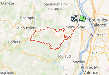
31 km | 41 km-effort
2h 0min
![](https://static1.geolcdn.com/siteimages/upload/files/16400158638029165_repeat_loop_refresh_sync_direction_icon.png)
Ja
![Tour Wandern Toulaud - Château de Crussol par Meyret - Photo](https://media.geolcdn.com/t/375/260/8477a480-9227-4102-b2db-afb6f5fa490e.jpg&format=jpg&maxdim=2)
![Wandern Wandern](https://static1.geolcdn.com/sitytour/trail-icons/101.png)
Château de Crussol par Meyret
Wandern
Medium
(1)
Toulaud,
Auvergne-Rhone-Alpen,
Ardèche,
France
![](/images/other/stat-length.png)
7,6 km | 11,1 km-effort
3h 14min
![](https://static1.geolcdn.com/siteimages/upload/files/16400158638029165_repeat_loop_refresh_sync_direction_icon.png)
Ja
![Tour Wandern Cornas - De Cornas à la Borne - Photo](https://media.geolcdn.com/t/375/260/ext.jpg?maxdim=2&url=https%3A%2F%2Fstatic1.geolcdn.com%2Fsiteimages%2Fupload%2Ffiles%2F1553511878bg_sport_marche.png)
![Wandern Wandern](https://static1.geolcdn.com/sitytour/trail-icons/101.png)
De Cornas à la Borne
Wandern
Schwierig
(1)
Cornas,
Auvergne-Rhone-Alpen,
Ardèche,
France
![](/images/other/stat-length.png)
12,3 km | 18,3 km-effort
4h 51min
![](https://static1.geolcdn.com/siteimages/upload/files/16400158638029165_repeat_loop_refresh_sync_direction_icon.png)
Ja
![Tour Wandern Saint-Péray - N_ST PERAY 07130 Baume des Bois - Crussol - Photo](https://media.geolcdn.com/t/375/260/ext.jpg?maxdim=2&url=https%3A%2F%2Fstatic1.geolcdn.com%2Fsiteimages%2Fupload%2Ffiles%2F1553511878bg_sport_marche.png)
![Wandern Wandern](https://static1.geolcdn.com/sitytour/trail-icons/101.png)
N_ST PERAY 07130 Baume des Bois - Crussol
Wandern
Einfach
(2)
Saint-Péray,
Auvergne-Rhone-Alpen,
Ardèche,
France
![](/images/other/stat-length.png)
4,2 km | 6,8 km-effort
1h 40min
![](https://static1.geolcdn.com/siteimages/upload/files/16400158638029165_repeat_loop_refresh_sync_direction_icon.png)
Ja
![Tour Wandern Saint-Péray - Château de Crussol - Photo](https://media.geolcdn.com/t/375/260/2cd125bb-0b9a-43a3-9b03-60bf63b22af5.jpg&format=jpg&maxdim=2)
![Wandern Wandern](https://static1.geolcdn.com/sitytour/trail-icons/101.png)
Château de Crussol
Wandern
Einfach
Saint-Péray,
Auvergne-Rhone-Alpen,
Ardèche,
France
![](/images/other/stat-length.png)
2,1 km | 3,5 km-effort
53min
![](https://static1.geolcdn.com/siteimages/upload/files/16400158638029165_repeat_loop_refresh_sync_direction_icon.png)
Ja
![Tour Wandern Saint-Péray - St Peray - Photo](https://media.geolcdn.com/t/375/260/f4637115-cc7a-4f13-bfda-10680f079d1e.jpg&format=jpg&maxdim=2)
![Wandern Wandern](https://static1.geolcdn.com/sitytour/trail-icons/101.png)
St Peray
Wandern
Schwierig
Saint-Péray,
Auvergne-Rhone-Alpen,
Ardèche,
France
![](/images/other/stat-length.png)
7,6 km | 12,4 km-effort
2h 49min
![](https://static1.geolcdn.com/siteimages/upload/files/16400158638029165_repeat_loop_refresh_sync_direction_icon.png)
Ja
![Tour Wandern Saint-Péray - saint peray - Photo](https://media.geolcdn.com/t/375/260/0ac7a899-a3f6-43d8-8e6c-a6c828bfc257.jpg&format=jpg&maxdim=2)
![Wandern Wandern](https://static1.geolcdn.com/sitytour/trail-icons/101.png)
saint peray
Wandern
Schwierig
(1)
Saint-Péray,
Auvergne-Rhone-Alpen,
Ardèche,
France
![](/images/other/stat-length.png)
15 km | 23 km-effort
5h 19min
![](https://static1.geolcdn.com/siteimages/upload/files/16400158638029165_repeat_loop_refresh_sync_direction_icon.png)
Ja
![Tour Wandern Saint-Péray - Le château de Crussol et ses crêtes - Photo](https://media.geolcdn.com/t/375/260/ab0e5341-d878-44c5-9329-3ce4a540f9aa.jpg&format=jpg&maxdim=2)
![Wandern Wandern](https://static1.geolcdn.com/sitytour/trail-icons/101.png)
Le château de Crussol et ses crêtes
Wandern
Einfach
Saint-Péray,
Auvergne-Rhone-Alpen,
Ardèche,
France
![](/images/other/stat-length.png)
9,9 km | 14,1 km-effort
2h 27min
![](https://static1.geolcdn.com/siteimages/upload/files/16400158638029165_repeat_loop_refresh_sync_direction_icon.png)
Ja
![Tour Wandern Saint-Romain-de-Lerps - barbara - Photo](https://media.geolcdn.com/t/375/260/ext.jpg?maxdim=2&url=https%3A%2F%2Fservices.sitytrail.com%2FGeolivesWS%2FDownloadMedia.ashx%3FTrailID%3D892245%26Media%3Dfix__20180123152902.jpg)
![Wandern Wandern](https://static1.geolcdn.com/sitytour/trail-icons/101.png)
barbara
Wandern
Sehr leicht
Saint-Romain-de-Lerps,
Auvergne-Rhone-Alpen,
Ardèche,
France
![](/images/other/stat-length.png)
4,9 km | 6,5 km-effort
1h 25min
![](https://static1.geolcdn.com/siteimages/upload/files/16400158638029165_repeat_loop_refresh_sync_direction_icon.png)
Ja