![](/images/other/stat-length.png)
![Tour Wandern Fontaine-de-Vaucluse - Fontaine de Vaucluse - Photo](https://media.geolcdn.com/t/1900/400/ext.pjpeg?maxdim=2&url=https%3A%2F%2Fstatic1.geolcdn.com%2Fsiteimages%2Fupload%2Ffiles%2F1553511878bg_sport_marche.png)
Fontaine de Vaucluse
MarcLEBARON
Benutzer
![Länge](/images/other/stat-length.png)
![Maximale Höhe](https://static1.geolcdn.com/siteimages/upload/files/1508320355ic_sort_altitude_max_24dp.png)
![Positive Höhendifferenz](https://static1.geolcdn.com/siteimages/upload/files/1508320355ic_sort_den_pos_24dp.png)
![Km-Effort](/images/other/stat-length.png)
![Min. Höhe](https://static1.geolcdn.com/siteimages/upload/files/1508320355ic_sort_altitude_min_24dp.png)
![Negative Höhendifferenz](https://static1.geolcdn.com/siteimages/upload/files/1508320355ic_sort_den_neg_24dp.png)
![Boucle](https://static1.geolcdn.com/siteimages/upload/files/16400158638029165_repeat_loop_refresh_sync_direction_icon.png)
![Wandern](https://static1.geolcdn.com/sitytour/trail-icons/101.png)
3h01
Schwierigkeit : Schwierig
![Scannen Sie diesen QR-Code, um die Tour in der SityTrail-Anwendung zu öffnen](https://capi.geolives.com/qq0zvz2zws4bq2lad0pu/sitytour/trails/159503/qr.png?size=200)
Kostenlosegpshiking-Anwendung
Über SityTrail
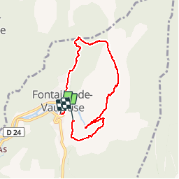
Tour Wandern von 7,2 km verfügbar auf Provence-Alpes-Côte d'Azur, Vaucluse, Fontaine-de-Vaucluse. Diese Tour wird von MarcLEBARON vorgeschlagen.
Beschreibung
Boucle permettant l'accès à la Fontaine de Vaucluse vue du haut de la falaise.
La partie "aller" de la cote 342 à 574 est raide... ensuite chemin sur crête très agréable avant d'arriver au point de vue sur la fontaine. Retour par le vallon de l'Oule et château (manque un petit bout sur tracé).
Ort
Kommentare
Touren in der Umgebung
![Tour Wandern Fontaine-de-Vaucluse - Fontaine de Vaucluse par l'aven de Valescure, les crêtes et le chateau - Photo](https://media.geolcdn.com/t/375/260/151070e1-18c8-4062-b1e4-7770840cd66e.jpg&format=jpg&maxdim=2)
![Wandern Wandern](https://static1.geolcdn.com/sitytour/trail-icons/101.png)
Wandern
![](/images/other/stat-length.png)
![](https://static1.geolcdn.com/siteimages/upload/files/16400158638029165_repeat_loop_refresh_sync_direction_icon.png)
![Tour Wandern Lagnes - Lagnes Tête du Soldat Mur de la peste Esperacons - Photo](https://media.geolcdn.com/t/375/260/a1cbca5d-1ba7-4e0a-a45d-e364265b058f.jpg&format=jpg&maxdim=2)
![Wandern Wandern](https://static1.geolcdn.com/sitytour/trail-icons/101.png)
Wandern
![](/images/other/stat-length.png)
![](https://static1.geolcdn.com/siteimages/upload/files/16400158638029165_repeat_loop_refresh_sync_direction_icon.png)
![Tour Wandern Saumane-de-Vaucluse - Saumane-de-Vaucluse très belle ballade - Photo](https://media.geolcdn.com/t/375/260/f13a2583-4146-473c-8c72-3b4870c42b13.jpg&format=jpg&maxdim=2)
![Wandern Wandern](https://static1.geolcdn.com/sitytour/trail-icons/101.png)
Wandern
![](/images/other/stat-length.png)
![](https://static1.geolcdn.com/siteimages/upload/files/16400158638029165_repeat_loop_refresh_sync_direction_icon.png)
![Tour Wandern Lagnes - Lagnes - La Tête du Soldat - Mur de la Peste - Photo](https://media.geolcdn.com/t/375/260/ext.jpg?maxdim=2&url=https%3A%2F%2Fservices.sitytrail.com%2FGeolivesWS%2FDownloadMedia.ashx%3FTrailID%3D103456%26Media%3D5577_2.jpg)
![Wandern Wandern](https://static1.geolcdn.com/sitytour/trail-icons/101.png)
Wandern
![](/images/other/stat-length.png)
![](https://static1.geolcdn.com/siteimages/upload/files/16400158638029165_repeat_loop_refresh_sync_direction_icon.png)
![Tour Wandern Fontaine-de-Vaucluse - Ballade le long du canal de Carpentras - Photo](https://media.geolcdn.com/t/375/260/3ef0eb2a-23ef-4d53-a230-1b96fa5cca74.jpg&format=jpg&maxdim=2)
![Wandern Wandern](https://static1.geolcdn.com/sitytour/trail-icons/101.png)
Wandern
![](/images/other/stat-length.png)
![](https://static1.geolcdn.com/siteimages/upload/files/16400158638029165_repeat_loop_refresh_sync_direction_icon.png)
![Tour Wandern Saumane-de-Vaucluse - Saumane de Vaucluse / St Gens - Photo](https://media.geolcdn.com/t/375/260/ad5fcb13-12d4-40a2-8637-46a71dbe09db.jpg&format=jpg&maxdim=2)
![Wandern Wandern](https://static1.geolcdn.com/sitytour/trail-icons/101.png)
Wandern
![](/images/other/stat-length.png)
![](https://static1.geolcdn.com/siteimages/upload/files/16400158638029165_repeat_loop_refresh_sync_direction_icon.png)
![Tour Wandern Lagnes - SityTrail - 2022-04-07_18h36m42_lagnes-et-le-mur-de-la-peste - Photo](https://media.geolcdn.com/t/375/260/3379eca8-2f59-4c0c-b19b-ccc327c00164.jpg&format=jpg&maxdim=2)
![Wandern Wandern](https://static1.geolcdn.com/sitytour/trail-icons/101.png)
Wandern
![](/images/other/stat-length.png)
![](https://static1.geolcdn.com/siteimages/upload/files/16400158638029165_repeat_loop_refresh_sync_direction_icon.png)
![Tour Wandern Saumane-de-Vaucluse - Saumane de Vaucluse / St Gens - Photo](https://media.geolcdn.com/t/375/260/0c9ad01a-5b0c-44c1-939a-8e6252f252a0.jpg&format=jpg&maxdim=2)
![Wandern Wandern](https://static1.geolcdn.com/sitytour/trail-icons/101.png)
Wandern
![](/images/other/stat-length.png)
![](https://static1.geolcdn.com/siteimages/upload/files/16400158638029165_repeat_loop_refresh_sync_direction_icon.png)
![Tour Hybrid-Bike Lagnes - La coutelière <> L’Isle Sur La Sorgue - Photo](https://media.geolcdn.com/t/375/260/ext.jpg?maxdim=2&url=https%3A%2F%2Fstatic1.geolcdn.com%2Fsiteimages%2Fupload%2Ffiles%2F1524743154velo.jpg)
![Hybrid-Bike Hybrid-Bike](https://static1.geolcdn.com/sitytour/trail-icons/203.png)
Hybrid-Bike
![](/images/other/stat-length.png)
![](https://static1.geolcdn.com/siteimages/upload/files/16400158638029165_repeat_loop_refresh_sync_direction_icon.png)