![](/images/other/stat-length.png)
![Tour Wandern Collias - GARD Gorges du Gardon, depuis Collias - Photo](https://media.geolcdn.com/t/1900/400/ext.pjpeg?maxdim=2&url=https%3A%2F%2Fstatic1.geolcdn.com%2Fsiteimages%2Fupload%2Ffiles%2F1553511878bg_sport_marche.png)
GARD Gorges du Gardon, depuis Collias
jmheydorff
Benutzer
![Länge](/images/other/stat-length.png)
![Maximale Höhe](https://static1.geolcdn.com/siteimages/upload/files/1508320355ic_sort_altitude_max_24dp.png)
![Positive Höhendifferenz](https://static1.geolcdn.com/siteimages/upload/files/1508320355ic_sort_den_pos_24dp.png)
![Km-Effort](/images/other/stat-length.png)
![Min. Höhe](https://static1.geolcdn.com/siteimages/upload/files/1508320355ic_sort_altitude_min_24dp.png)
![Negative Höhendifferenz](https://static1.geolcdn.com/siteimages/upload/files/1508320355ic_sort_den_neg_24dp.png)
![Boucle](https://static1.geolcdn.com/siteimages/upload/files/16400158638029165_repeat_loop_refresh_sync_direction_icon.png)
![Wandern](https://static1.geolcdn.com/sitytour/trail-icons/101.png)
5h00
Schwierigkeit : Medium
![Scannen Sie diesen QR-Code, um die Tour in der SityTrail-Anwendung zu öffnen](https://capi.geolives.com/qq0zvz2zws4bq2lad0pu/sitytour/trails/148269/qr.png?size=200)
Kostenlosegpshiking-Anwendung
Über SityTrail
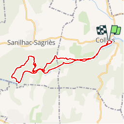
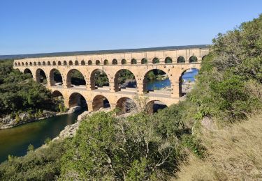
Tour Wandern von 16,5 km verfügbar auf Okzitanien, Gard, Collias. Diese Tour wird von jmheydorff vorgeschlagen.
Beschreibung
Pkg du marché CV, sur l'avenue du pont (D3)- Est jusqu'au Pont; descendre et longer la rive gauche (Nord) du Gardon sur 1,5 kms.
Monter à la grotte, continuer jusqu'au GR 6/63; le prendre à gauche; à 500m, aller voir le gouffre (attention,non protégé).
passer par un vague sentier SW qui rejoint après 500m un autre qui descend Sud, et on atteint la grotte et le tunnel (lampes de poches ou frontales), puis la chapelle Ste Vérédème, au bord du Gardon, au lieu dit La Baume.
Monter W un sentier en surplomb du Gardon, et entamer des S (points de vue magnifiques sur la Baume.
On peut revenir depuis ces virages (côte 100m environ), et longer le gardon jusqu'à Collias (parcours limité à 14kms et dénivelé 430 m.
Si on se sent suffisamment frais, on peut continuer le sentier qui rejoint à nouveau le GR 6/63; on le quitte vers le point côté 178 m, par un sentier bien tracé SW puis S, jusqu'au bord de la falaise; on descend alors par un sentier difficile,étroit et pentu, jusqu'au Gardon, que l'on remonte jusqu'à Collias.
La remontée peut se faire par le village, en prenant la 1° rue à gauche (rue du Barry), puis l'escalier et la rue du Bas Quartier, et la rue de la République.
Ort
Kommentare
Touren in der Umgebung
![Tour Wandern Vers-Pont-du-Gard - Rando pont du Gard - Photo](https://media.geolcdn.com/t/375/260/ext.jpg?maxdim=2&url=https%3A%2F%2Fservices.sitytrail.com%2FGeolivesWS%2FDownloadMedia.ashx%3FTrailID%3D895180%26Media%3Dfix__20180128154606.jpg)
![Wandern Wandern](https://static1.geolcdn.com/sitytour/trail-icons/101.png)
Wandern
![](/images/other/stat-length.png)
![](https://static1.geolcdn.com/siteimages/upload/files/16400158638029165_repeat_loop_refresh_sync_direction_icon.png)
![Wandern Wandern](https://static1.geolcdn.com/sitytour/trail-icons/101.png)
Wandern
![](/images/other/stat-length.png)
![](https://static1.geolcdn.com/siteimages/upload/files/16400158638029165_repeat_loop_refresh_sync_direction_icon.png)
![Tour Wandern Argilliers - Les Darbounelles - Argilliers - Photo](https://media.geolcdn.com/t/375/260/ext.jpg?maxdim=2&url=https%3A%2F%2Fservices.sitytrail.com%2FGeolivesWS%2FDownloadMedia.ashx%3FTrailID%3D214850%26Media%3D15388_6.jpg)
![Wandern Wandern](https://static1.geolcdn.com/sitytour/trail-icons/101.png)
Wandern
![](/images/other/stat-length.png)
![](https://static1.geolcdn.com/siteimages/upload/files/16400158638029165_repeat_loop_refresh_sync_direction_icon.png)
![Tour Laufen Saint-Maximin - St-Maximin et la vallée d'Eure - Photo](https://media.geolcdn.com/t/375/260/ext.jpg?maxdim=2&url=https%3A%2F%2Fservices.sitytrail.com%2FGeolivesWS%2FDownloadMedia.ashx%3FTrailID%3D173131%26Media%3D14685_6.jpg)
![Laufen Laufen](https://static1.geolcdn.com/sitytour/trail-icons/103.png)
Laufen
![](/images/other/stat-length.png)
![](https://static1.geolcdn.com/siteimages/upload/files/16400158638029165_repeat_loop_refresh_sync_direction_icon.png)
![Tour Wandern Collias - La Baume par Collias - Photo](https://media.geolcdn.com/t/375/260/ext.jpg?maxdim=2&url=https%3A%2F%2Fservices.sitytrail.com%2FGeolivesWS%2FDownloadMedia.ashx%3FTrailID%3D104695%26Media%3D8102_6.jpg)
![Wandern Wandern](https://static1.geolcdn.com/sitytour/trail-icons/101.png)
Wandern
![](/images/other/stat-length.png)
![](https://static1.geolcdn.com/siteimages/upload/files/16400158638029165_repeat_loop_refresh_sync_direction_icon.png)
![Tour Wandern Poulx - Balcon sur Gorges du Gardon - Photo](https://media.geolcdn.com/t/375/260/b4f466dc-2d62-4b2c-95b4-3708a6ba2370.jpg&format=jpg&maxdim=2)
![Wandern Wandern](https://static1.geolcdn.com/sitytour/trail-icons/101.png)
Wandern
![](/images/other/stat-length.png)
![](https://static1.geolcdn.com/siteimages/upload/files/16400158638029165_repeat_loop_refresh_sync_direction_icon.png)
![Tour Zu Fuß Collias - L'Ermitage de Collias - Photo](https://media.geolcdn.com/t/375/260/c473495e-e6e8-4c81-b296-56e817ace246.jpeg&format=jpg&maxdim=2)
![Zu Fuß Zu Fuß](https://static1.geolcdn.com/sitytour/trail-icons/100.png)
Zu Fuß
![](/images/other/stat-length.png)
![](https://static1.geolcdn.com/siteimages/upload/files/16400158638029165_repeat_loop_refresh_sync_direction_icon.png)
![Tour Wandern Vers-Pont-du-Gard - Vers-pont-du-gard panorama-dfci - Photo](https://media.geolcdn.com/t/375/260/364a41da-e920-4623-9a68-e6731453cac6.jpg&format=jpg&maxdim=2)
![Wandern Wandern](https://static1.geolcdn.com/sitytour/trail-icons/101.png)
Wandern
![](/images/other/stat-length.png)
![](https://static1.geolcdn.com/siteimages/upload/files/16400158638029165_repeat_loop_refresh_sync_direction_icon.png)
![Tour Wandern Cabrières - 30 gardon bois des coufines - Photo](https://media.geolcdn.com/t/375/260/2e1df956-cd25-48f9-b572-2f56a2c48a3c.jpg&format=jpg&maxdim=2)
![Wandern Wandern](https://static1.geolcdn.com/sitytour/trail-icons/101.png)
Wandern
![](/images/other/stat-length.png)
![](https://static1.geolcdn.com/siteimages/upload/files/16400158638029165_repeat_loop_refresh_sync_direction_icon.png)