![](/images/other/stat-length.png)
![Tour Laufen Sainte-Austreberthe - Hivernale du Raid Normand - Photo](https://media.geolcdn.com/t/1900/400/ext.pjpeg?maxdim=2&url=https%3A%2F%2Fstatic1.geolcdn.com%2Fsiteimages%2Fupload%2Ffiles%2F1524743154running.jpg)
Hivernale du Raid Normand
hgoye
Benutzer
![Länge](/images/other/stat-length.png)
Länge
48 km
![Maximale Höhe](https://static1.geolcdn.com/siteimages/upload/files/1508320355ic_sort_altitude_max_24dp.png)
Maximale Höhe
154 m
![Positive Höhendifferenz](https://static1.geolcdn.com/siteimages/upload/files/1508320355ic_sort_den_pos_24dp.png)
Positive Höhendifferenz
933 m
![Km-Effort](/images/other/stat-length.png)
Km-Effort
61 km
![Min. Höhe](https://static1.geolcdn.com/siteimages/upload/files/1508320355ic_sort_altitude_min_24dp.png)
Min. Höhe
2 m
![Negative Höhendifferenz](https://static1.geolcdn.com/siteimages/upload/files/1508320355ic_sort_den_neg_24dp.png)
Negative Höhendifferenz
1049 m
![Boucle](https://static1.geolcdn.com/siteimages/upload/files/16400158638029165_repeat_loop_refresh_sync_direction_icon.png)
Boucle
Nein
Erstellungsdatum :
2014-12-10 00:00:00.0
Letzte Änderung :
2014-12-10 00:00:00.0
![Laufen](https://static1.geolcdn.com/sitytour/trail-icons/103.png)
10h29
Schwierigkeit : Sehr schwierig
![Scannen Sie diesen QR-Code, um die Tour in der SityTrail-Anwendung zu öffnen](https://capi.geolives.com/qq0zvz2zws4bq2lad0pu/sitytour/trails/146915/qr.png?size=200)
Kostenlosegpshiking-Anwendung
Über SityTrail
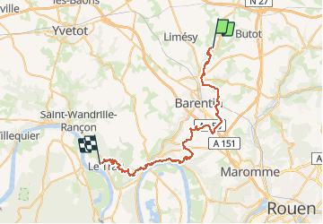
Tour Laufen von 48 km verfügbar auf Normandie, Seine-Maritime, Sainte-Austreberthe. Diese Tour wird von hgoye vorgeschlagen.
Beschreibung
Parcours de l'hivernale du RAID Normand 2012. Parcours 42 kilomètres (à la base) qui en fait pas loin de 49 en définitive.
POIs
Ort
Land:
France
Region :
Normandie
Abteilung/Provinz :
Seine-Maritime
Kommune :
Sainte-Austreberthe
Standort:
Unknown
Gehen Sie:(Dec)
Gehen Sie:(UTM)
353612 ; 5496163 (31U) N.
Kommentare
Touren in der Umgebung
![Tour Wandern Pavilly - 076-90-Pavilly / St Autreberthe 13.5km - Photo](https://media.geolcdn.com/t/375/260/a210e569-e658-42b2-bef9-eb8848a71140.jpg&format=jpg&maxdim=2)
![Wandern Wandern](https://static1.geolcdn.com/sitytour/trail-icons/101.png)
076-90-Pavilly / St Autreberthe 13.5km
Wandern
Medium
(1)
Pavilly,
Normandie,
Seine-Maritime,
France
![](/images/other/stat-length.png)
12 km | 15 km-effort
3h 23min
![](https://static1.geolcdn.com/siteimages/upload/files/16400158638029165_repeat_loop_refresh_sync_direction_icon.png)
Ja
![Wandern Wandern](https://static1.geolcdn.com/sitytour/trail-icons/101.png)
20220203-Pavilly
Wandern
Medium
Pavilly,
Normandie,
Seine-Maritime,
France
![](/images/other/stat-length.png)
12,1 km | 15 km-effort
3h 36min
![](https://static1.geolcdn.com/siteimages/upload/files/16400158638029165_repeat_loop_refresh_sync_direction_icon.png)
Ja
![Tour Wandern Butot - Butot -76- Chemin de randonnée le BOis de Grosfy - Photo](https://media.geolcdn.com/t/375/260/f0adff7e-0510-443c-91e0-549769fd08c0.jpg&format=jpg&maxdim=2)
![Wandern Wandern](https://static1.geolcdn.com/sitytour/trail-icons/101.png)
Butot -76- Chemin de randonnée le BOis de Grosfy
Wandern
Schwierig
Butot,
Normandie,
Seine-Maritime,
France
![](/images/other/stat-length.png)
14,5 km | 16,7 km-effort
4h 3min
![](https://static1.geolcdn.com/siteimages/upload/files/16400158638029165_repeat_loop_refresh_sync_direction_icon.png)
Ja
![Tour Wandern Pavilly - Pavilly St. Austreberthe (51) - Photo](https://media.geolcdn.com/t/375/260/ext.jpg?maxdim=2&url=https%3A%2F%2Fstatic1.geolcdn.com%2Fsiteimages%2Fupload%2Ffiles%2F1553511878bg_sport_marche.png)
![Wandern Wandern](https://static1.geolcdn.com/sitytour/trail-icons/101.png)
Pavilly St. Austreberthe (51)
Wandern
Einfach
(2)
Pavilly,
Normandie,
Seine-Maritime,
France
![](/images/other/stat-length.png)
10,3 km | 13 km-effort
2h 49min
![](https://static1.geolcdn.com/siteimages/upload/files/16400158638029165_repeat_loop_refresh_sync_direction_icon.png)
Ja
![Tour Wandern Goupillières - Goupillieres 6 - Photo](https://media.geolcdn.com/t/375/260/d20b3b5a-9e1f-403e-b83f-9397a3ba6e1b.jpg&format=jpg&maxdim=2)
![Wandern Wandern](https://static1.geolcdn.com/sitytour/trail-icons/101.png)
Goupillieres 6
Wandern
Einfach
Goupillières,
Normandie,
Seine-Maritime,
France
![](/images/other/stat-length.png)
6,8 km | 7,6 km-effort
1h 40min
![](https://static1.geolcdn.com/siteimages/upload/files/16400158638029165_repeat_loop_refresh_sync_direction_icon.png)
Ja
![Tour Zu Fuß Hugleville-en-Caux - Le Bois de Grofys - Photo](https://media.geolcdn.com/t/375/260/ext.jpg?maxdim=2&url=https%3A%2F%2Fstatic1.geolcdn.com%2Fsiteimages%2Fupload%2Ffiles%2F1545311037marcheuse_200dpi.jpg)
![Zu Fuß Zu Fuß](https://static1.geolcdn.com/sitytour/trail-icons/100.png)
Le Bois de Grofys
Zu Fuß
Einfach
Hugleville-en-Caux,
Normandie,
Seine-Maritime,
France
![](/images/other/stat-length.png)
11,6 km | 13,3 km-effort
3h 1min
![](https://static1.geolcdn.com/siteimages/upload/files/16400158638029165_repeat_loop_refresh_sync_direction_icon.png)
Ja
![Tour Zu Fuß Pavilly - 2020-01-22_15h00m10_20200125-pavilly - Photo](https://media.geolcdn.com/t/375/260/fca199ec-9bf4-4b5c-87b4-2fd7de5421ae.jpg&format=jpg&maxdim=2)
![Zu Fuß Zu Fuß](https://static1.geolcdn.com/sitytour/trail-icons/100.png)
2020-01-22_15h00m10_20200125-pavilly
Zu Fuß
Sehr leicht
Pavilly,
Normandie,
Seine-Maritime,
France
![](/images/other/stat-length.png)
13 km | 16 km-effort
Unbekannt
![](https://static1.geolcdn.com/siteimages/upload/files/16400158638029165_repeat_loop_refresh_sync_direction_icon.png)
Ja
![Tour Wandern Sainte-Austreberthe - Ste Austreberthe Pavilly A-R - Photo](https://media.geolcdn.com/t/375/260/ext.jpg?maxdim=2&url=https%3A%2F%2Fservices.sitytrail.com%2FGeolivesWS%2FDownloadMedia.ashx%3FTrailID%3D908132%26Media%3Dfix__20180218155800.jpg)
![Wandern Wandern](https://static1.geolcdn.com/sitytour/trail-icons/101.png)
Ste Austreberthe Pavilly A-R
Wandern
Schwierig
Sainte-Austreberthe,
Normandie,
Seine-Maritime,
France
![](/images/other/stat-length.png)
12,5 km | 15,6 km-effort
3h 7min
![](https://static1.geolcdn.com/siteimages/upload/files/16400158638029165_repeat_loop_refresh_sync_direction_icon.png)
Ja
![Tour Wandern Pavilly - 076-89-Pavilly Ste Austreberthe route du Lin 11km-877-716- - Photo](https://media.geolcdn.com/t/375/260/67b859b5-ac7f-468e-ba6f-19151b8fc1e7.jpg&format=jpg&maxdim=2)
![Wandern Wandern](https://static1.geolcdn.com/sitytour/trail-icons/101.png)
076-89-Pavilly Ste Austreberthe route du Lin 11km-877-716-
Wandern
Einfach
Pavilly,
Normandie,
Seine-Maritime,
France
![](/images/other/stat-length.png)
11 km | 13,7 km-effort
2h 56min
![](https://static1.geolcdn.com/siteimages/upload/files/16400158638029165_repeat_loop_refresh_sync_direction_icon.png)
Ja