![](/images/other/stat-length.png)
![Tour Wandern Réallon - aiguilles de chabrillaire - Photo](https://media.geolcdn.com/t/1900/400/ext.pjpeg?maxdim=2&url=https%3A%2F%2Fservices.sitytrail.com%2FGeolivesWS%2FDownloadMedia.ashx%3FTrailID%3D145128%26Media%3D20120809135832.jpg)
aiguilles de chabrillaire
jackygoupillat
Benutzer
![Länge](/images/other/stat-length.png)
![Maximale Höhe](https://static1.geolcdn.com/siteimages/upload/files/1508320355ic_sort_altitude_max_24dp.png)
![Positive Höhendifferenz](https://static1.geolcdn.com/siteimages/upload/files/1508320355ic_sort_den_pos_24dp.png)
![Km-Effort](/images/other/stat-length.png)
![Min. Höhe](https://static1.geolcdn.com/siteimages/upload/files/1508320355ic_sort_altitude_min_24dp.png)
![Negative Höhendifferenz](https://static1.geolcdn.com/siteimages/upload/files/1508320355ic_sort_den_neg_24dp.png)
![Boucle](https://static1.geolcdn.com/siteimages/upload/files/16400158638029165_repeat_loop_refresh_sync_direction_icon.png)
![Wandern](https://static1.geolcdn.com/sitytour/trail-icons/101.png)
3h54
Schwierigkeit : Unbekannt
![Scannen Sie diesen QR-Code, um die Tour in der SityTrail-Anwendung zu öffnen](https://capi.geolives.com/qq0zvz2zws4bq2lad0pu/sitytour/trails/145128/qr.png?size=200)
Kostenlosegpshiking-Anwendung
Über SityTrail
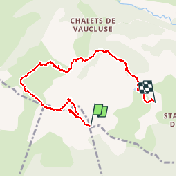
Tour Wandern von 8,4 km verfügbar auf Provence-Alpes-Côte d'Azur, Hochalpen, Réallon. Diese Tour wird von jackygoupillat vorgeschlagen.
Beschreibung
Parking de la station de realon . Prendre le télésiège jusqu à la table d'orientation et prendre le chemin à droite( bleu) vers la brèche. Montée raide et pierreuse mais vue fantastique qui récompense cet effort. Continuer le chemin après le col pour faire la crête avec vue vertigineuse sur le lac déserte pinçon et de tous les pics de la chaîne continuer le chemin( bleu) vers le retour 1er tronçon de télésiège .compter 2h30 après le passage de la brèche .rando magnifique avec vue et chemin très divers
Ort
Kommentare
Touren in der Umgebung
![Tour Wandern Réallon - AIguilles de Chabrieres au départ de la Station de ski Reallon - Photo](https://media.geolcdn.com/t/375/260/023f36e8-d4bb-4840-8d02-c81493ac1dcf.jpg&format=jpg&maxdim=2)
![Wandern Wandern](https://static1.geolcdn.com/sitytour/trail-icons/101.png)
Wandern
![](/images/other/stat-length.png)
![](https://static1.geolcdn.com/siteimages/upload/files/16400158638029165_repeat_loop_refresh_sync_direction_icon.png)
![Tour Wandern Réallon - Aiguilles de Chabrière - Photo](https://media.geolcdn.com/t/375/260/876aeb30-4d0c-470b-9156-901c8d05e3da.jpg&format=jpg&maxdim=2)
![Wandern Wandern](https://static1.geolcdn.com/sitytour/trail-icons/101.png)
Wandern
![](/images/other/stat-length.png)
![](https://static1.geolcdn.com/siteimages/upload/files/16400158638029165_repeat_loop_refresh_sync_direction_icon.png)
![Tour Wandern Réallon - le fort de Réallon - Photo](https://media.geolcdn.com/t/375/260/ext.jpg?maxdim=2&url=https%3A%2F%2Fservices.sitytrail.com%2FGeolivesWS%2FDownloadMedia.ashx%3FTrailID%3D731825%26Media%3Dfix__20170413090038.jpg)
![Wandern Wandern](https://static1.geolcdn.com/sitytour/trail-icons/101.png)
Wandern
![](/images/other/stat-length.png)
![](https://static1.geolcdn.com/siteimages/upload/files/16400158638029165_repeat_loop_refresh_sync_direction_icon.png)
![Tour Wandern Réallon - SityTrail - 2556786 - aiguilles-de-chabriere - Photo](https://media.geolcdn.com/t/375/260/ac3bac5b-f81d-4550-9055-615639b581a1.jpg&format=jpg&maxdim=2)
![Wandern Wandern](https://static1.geolcdn.com/sitytour/trail-icons/101.png)
Wandern
![](/images/other/stat-length.png)
![](https://static1.geolcdn.com/siteimages/upload/files/16400158638029165_repeat_loop_refresh_sync_direction_icon.png)
![Tour Schneeschuhwandern Réallon - Raquettes Réallon - Photo](https://media.geolcdn.com/t/375/260/95a04571-4c6f-4065-a8af-914af77e268b.jpg&format=jpg&maxdim=2)
![Schneeschuhwandern Schneeschuhwandern](https://static1.geolcdn.com/sitytour/trail-icons/504.png)
Schneeschuhwandern
![](/images/other/stat-length.png)
![](https://static1.geolcdn.com/siteimages/upload/files/16400158638029165_repeat_loop_refresh_sync_direction_icon.png)
![Tour Wandern Réallon - Reallon-Serre du Mouton 7km - Photo](https://media.geolcdn.com/t/375/260/9684f183-cb02-48c2-8699-e3c8ee97d988.jpg&format=jpg&maxdim=2)
![Wandern Wandern](https://static1.geolcdn.com/sitytour/trail-icons/101.png)
Wandern
![](/images/other/stat-length.png)
![](https://static1.geolcdn.com/siteimages/upload/files/16400158638029165_repeat_loop_refresh_sync_direction_icon.png)
![Tour Wandern Chorges - Les Parias et la Pousterle par le col de Chorges - Photo](https://media.geolcdn.com/t/375/260/8b1f1fa4-aaef-4c81-bd3d-65cfa8c4cbf8.jpg&format=jpg&maxdim=2)
![Wandern Wandern](https://static1.geolcdn.com/sitytour/trail-icons/101.png)
Wandern
![](/images/other/stat-length.png)
![](https://static1.geolcdn.com/siteimages/upload/files/16400158638029165_repeat_loop_refresh_sync_direction_icon.png)
![Tour Wandern Saint-Apollinaire - Aiguilles Chabrieres 08/08/18 - Photo](https://media.geolcdn.com/t/375/260/78ddfe44-69e9-44e6-832a-38dad99571c4.jpg&format=jpg&maxdim=2)
![Wandern Wandern](https://static1.geolcdn.com/sitytour/trail-icons/101.png)
Wandern
![](/images/other/stat-length.png)
![](https://static1.geolcdn.com/siteimages/upload/files/16400158638029165_repeat_loop_refresh_sync_direction_icon.png)
![Tour Wandern Réallon - Embrunais - Réallon Le Fort - 3.2km 200m 1h10 - 2018 06 28 - public - Photo](https://media.geolcdn.com/t/375/260/ext.jpg?maxdim=2&url=https%3A%2F%2Fservices.sitytrail.com%2FGeolivesWS%2FDownloadMedia.ashx%3FTrailID%3D999119%26Media%3Dfix__20180628151303.jpg)
![Wandern Wandern](https://static1.geolcdn.com/sitytour/trail-icons/101.png)
Wandern
![](/images/other/stat-length.png)
![](https://static1.geolcdn.com/siteimages/upload/files/16400158638029165_repeat_loop_refresh_sync_direction_icon.png)