![](/images/other/stat-length.png)
![Tour Fahrrad Le Pont-de-Beauvoisin - 20120801 Milles marthyrs i - Photo](https://media.geolcdn.com/t/1900/400/ext.pjpeg?maxdim=2&url=https%3A%2F%2Fstatic1.geolcdn.com%2Fsiteimages%2Fupload%2Ffiles%2F1524743154velo.jpg)
20120801 Milles marthyrs i
TaxiMarne
Benutzer
![Länge](/images/other/stat-length.png)
Länge
48 km
![Maximale Höhe](https://static1.geolcdn.com/siteimages/upload/files/1508320355ic_sort_altitude_max_24dp.png)
Maximale Höhe
886 m
![Positive Höhendifferenz](https://static1.geolcdn.com/siteimages/upload/files/1508320355ic_sort_den_pos_24dp.png)
Positive Höhendifferenz
964 m
![Km-Effort](/images/other/stat-length.png)
Km-Effort
61 km
![Min. Höhe](https://static1.geolcdn.com/siteimages/upload/files/1508320355ic_sort_altitude_min_24dp.png)
Min. Höhe
251 m
![Negative Höhendifferenz](https://static1.geolcdn.com/siteimages/upload/files/1508320355ic_sort_den_neg_24dp.png)
Negative Höhendifferenz
962 m
![Boucle](https://static1.geolcdn.com/siteimages/upload/files/16400158638029165_repeat_loop_refresh_sync_direction_icon.png)
Boucle
Ja
Erstellungsdatum :
2014-12-10 00:00:00.0
Letzte Änderung :
2014-12-10 00:00:00.0
![Fahrrad](https://static1.geolcdn.com/sitytour/trail-icons/200.png)
3h09
Schwierigkeit : Schwierig
![Scannen Sie diesen QR-Code, um die Tour in der SityTrail-Anwendung zu öffnen](https://capi.geolives.com/qq0zvz2zws4bq2lad0pu/sitytour/trails/142882/qr.png?size=200)
Kostenlosegpshiking-Anwendung
Über SityTrail
Tour Fahrrad von 48 km verfügbar auf Auvergne-Rhone-Alpen, Savoyen, Le Pont-de-Beauvoisin. Diese Tour wird von TaxiMarne vorgeschlagen.
Beschreibung
Départ de Pont de Beauvoisin savoie, passage dans les gorges de Chailles, aux Echelles, montée du col des milles marthyrs, descente par Saint-Geoir en valdaine puis retour à Pont de Beauvoisin par St Albin de vaulserre. Un très joli circuit.
Ort
Land:
France
Region :
Auvergne-Rhone-Alpen
Abteilung/Provinz :
Savoyen
Kommune :
Le Pont-de-Beauvoisin
Standort:
Unknown
Gehen Sie:(Dec)
Gehen Sie:(UTM)
708633 ; 5046067 (31T) N.
Kommentare
Touren in der Umgebung
![Wandern Wandern](https://static1.geolcdn.com/sitytour/trail-icons/101.png)
Col du Banchet-G1
Wandern
Medium
Ayn,
Auvergne-Rhone-Alpen,
Savoyen,
France
![](/images/other/stat-length.png)
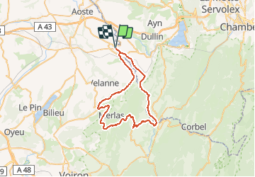
8,2 km | 11,9 km-effort
2h 29min
![](https://static1.geolcdn.com/siteimages/upload/files/16400158638029165_repeat_loop_refresh_sync_direction_icon.png)
Ja
![Tour Rennrad Les Abrets en Dauphiné - Lac de paladru au départ de la bâtie - Photo](https://media.geolcdn.com/t/375/260/ext.jpg?maxdim=2&url=https%3A%2F%2Fstatic1.geolcdn.com%2Fsiteimages%2Fupload%2Ffiles%2F1524743154velo.jpg)
![Rennrad Rennrad](https://static1.geolcdn.com/sitytour/trail-icons/201.png)
Lac de paladru au départ de la bâtie
Rennrad
Einfach
Les Abrets en Dauphiné,
Auvergne-Rhone-Alpen,
Isère,
France
![](/images/other/stat-length.png)
29 km | 35 km-effort
1h 34min
![](https://static1.geolcdn.com/siteimages/upload/files/16400158638029165_repeat_loop_refresh_sync_direction_icon.png)
Ja
![Tour Rennrad Les Abrets en Dauphiné - Boucle départ la bâtie Divisin - Photo](https://media.geolcdn.com/t/375/260/ext.jpg?maxdim=2&url=https%3A%2F%2Fstatic1.geolcdn.com%2Fsiteimages%2Fupload%2Ffiles%2F1524743154velo.jpg)
![Rennrad Rennrad](https://static1.geolcdn.com/sitytour/trail-icons/201.png)
Boucle départ la bâtie Divisin
Rennrad
Medium
Les Abrets en Dauphiné,
Auvergne-Rhone-Alpen,
Isère,
France
![](/images/other/stat-length.png)
30 km | 36 km-effort
1h 47min
![](https://static1.geolcdn.com/siteimages/upload/files/16400158638029165_repeat_loop_refresh_sync_direction_icon.png)
Ja
![Tour Wandern Ayn - LE BANCHET-G1 BIS-17-03-23 - Photo](https://media.geolcdn.com/t/375/260/ext.jpg?maxdim=2&url=https%3A%2F%2Fstatic1.geolcdn.com%2Fsiteimages%2Fupload%2Ffiles%2F1553511878bg_sport_marche.png)
![Wandern Wandern](https://static1.geolcdn.com/sitytour/trail-icons/101.png)
LE BANCHET-G1 BIS-17-03-23
Wandern
Medium
Ayn,
Auvergne-Rhone-Alpen,
Savoyen,
France
![](/images/other/stat-length.png)
7,7 km | 11,4 km-effort
2h 35min
![](https://static1.geolcdn.com/siteimages/upload/files/16400158638029165_repeat_loop_refresh_sync_direction_icon.png)
Ja
![Tour Wandern Ayn - LE BANCHET-G2 BIS-17-03-23 - Photo](https://media.geolcdn.com/t/375/260/ext.jpg?maxdim=2&url=https%3A%2F%2Fstatic1.geolcdn.com%2Fsiteimages%2Fupload%2Ffiles%2F1553511878bg_sport_marche.png)
![Wandern Wandern](https://static1.geolcdn.com/sitytour/trail-icons/101.png)
LE BANCHET-G2 BIS-17-03-23
Wandern
Medium
Ayn,
Auvergne-Rhone-Alpen,
Savoyen,
France
![](/images/other/stat-length.png)
5,8 km | 8,6 km-effort
1h 57min
![](https://static1.geolcdn.com/siteimages/upload/files/16400158638029165_repeat_loop_refresh_sync_direction_icon.png)
Ja
![Tour Reiten Pressins - 202210 RallyePressins J2 - Photo](https://media.geolcdn.com/t/375/260/ext.jpg?maxdim=2&url=https%3A%2F%2Fstatic1.geolcdn.com%2Fsiteimages%2Fupload%2Ffiles%2F1524743154cheval.jpg)
![Reiten Reiten](https://static1.geolcdn.com/sitytour/trail-icons/301.png)
202210 RallyePressins J2
Reiten
Medium
Pressins,
Auvergne-Rhone-Alpen,
Isère,
France
![](/images/other/stat-length.png)
15,7 km | 21 km-effort
2h 30min
![](https://static1.geolcdn.com/siteimages/upload/files/16400158638029165_repeat_loop_refresh_sync_direction_icon.png)
Ja
![Tour Reiten Pressins - 202210 RallyePressin J1 - Photo](https://media.geolcdn.com/t/375/260/ext.jpg?maxdim=2&url=https%3A%2F%2Fstatic1.geolcdn.com%2Fsiteimages%2Fupload%2Ffiles%2F1524743154cheval.jpg)
![Reiten Reiten](https://static1.geolcdn.com/sitytour/trail-icons/301.png)
202210 RallyePressin J1
Reiten
Medium
Pressins,
Auvergne-Rhone-Alpen,
Isère,
France
![](/images/other/stat-length.png)
26 km | 33 km-effort
3h 30min
![](https://static1.geolcdn.com/siteimages/upload/files/16400158638029165_repeat_loop_refresh_sync_direction_icon.png)
Ja
![Tour Reiten Avressieux - col de la lattaz la crusille - Photo](https://media.geolcdn.com/t/375/260/ext.jpg?maxdim=2&url=https%3A%2F%2Fstatic1.geolcdn.com%2Fsiteimages%2Fupload%2Ffiles%2F1524743154cheval.jpg)
![Reiten Reiten](https://static1.geolcdn.com/sitytour/trail-icons/301.png)
col de la lattaz la crusille
Reiten
Medium
Avressieux,
Auvergne-Rhone-Alpen,
Savoyen,
France
![](/images/other/stat-length.png)
17,2 km | 25 km-effort
4h 5min
![](https://static1.geolcdn.com/siteimages/upload/files/16400158638029165_repeat_loop_refresh_sync_direction_icon.png)
Ja
![Zu Fuß Zu Fuß](https://static1.geolcdn.com/sitytour/trail-icons/100.png)
Col du Banchet-G2
Zu Fuß
Einfach
Ayn,
Auvergne-Rhone-Alpen,
Savoyen,
France
![](/images/other/stat-length.png)
6,5 km | 9,3 km-effort
Unbekannt
![](https://static1.geolcdn.com/siteimages/upload/files/16400158638029165_repeat_loop_refresh_sync_direction_icon.png)
Ja