![](/images/other/stat-length.png)
![Tour Wandern Foulbec - Foulbec et les trois côtes - Photo](https://media.geolcdn.com/t/1900/400/ext.pjpeg?maxdim=2&url=https%3A%2F%2Fservices.sitytrail.com%2FGeolivesWS%2FDownloadMedia.ashx%3FTrailID%3D129782%26Media%3D13326_1.jpg)
Foulbec et les trois côtes
tracegps
Benutzer
![Länge](/images/other/stat-length.png)
Länge
17,4 km
![Maximale Höhe](https://static1.geolcdn.com/siteimages/upload/files/1508320355ic_sort_altitude_max_24dp.png)
Maximale Höhe
115 m
![Positive Höhendifferenz](https://static1.geolcdn.com/siteimages/upload/files/1508320355ic_sort_den_pos_24dp.png)
Positive Höhendifferenz
328 m
![Km-Effort](/images/other/stat-length.png)
Km-Effort
22 km
![Min. Höhe](https://static1.geolcdn.com/siteimages/upload/files/1508320355ic_sort_altitude_min_24dp.png)
Min. Höhe
6 m
![Negative Höhendifferenz](https://static1.geolcdn.com/siteimages/upload/files/1508320355ic_sort_den_neg_24dp.png)
Negative Höhendifferenz
325 m
![Boucle](https://static1.geolcdn.com/siteimages/upload/files/16400158638029165_repeat_loop_refresh_sync_direction_icon.png)
Boucle
Ja
Erstellungsdatum :
2014-12-10 00:00:00.0
Letzte Änderung :
2014-12-10 00:00:00.0
![Wandern](https://static1.geolcdn.com/sitytour/trail-icons/101.png)
3h25
Schwierigkeit : Medium
![Scannen Sie diesen QR-Code, um die Tour in der SityTrail-Anwendung zu öffnen](https://capi.geolives.com/qq0zvz2zws4bq2lad0pu/sitytour/trails/129782/qr.png?size=200)
Kostenlosegpshiking-Anwendung
Über SityTrail
Tour Wandern von 17,4 km verfügbar auf Normandie, Eure, Foulbec. Diese Tour wird von tracegps vorgeschlagen.
Beschreibung
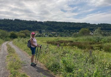
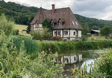
Balade autour des trois côtes à l'ouest de Foulbec: la Côte Maquaire, la Côte du Val Jouan et celle du Petit Hébert. Petits chemins de campagne et paysages Normands garantis ! A retrouver sur Balades en Normandie.
Ort
Land:
France
Region :
Normandie
Abteilung/Provinz :
Eure
Kommune :
Foulbec
Standort:
Unknown
Gehen Sie:(Dec)
Gehen Sie:(UTM)
313192 ; 5475040 (31U) N.
Kommentare
Touren in der Umgebung
![Tour Wandern Marais-Vernier - 2022-04-08_19h09m39_SityTrail - 3194311 - 20220409xmarais-vernier-10km - Photo](https://media.geolcdn.com/t/375/260/b613f315-8627-4fd7-a202-639fbd00f8cd.jpg&format=jpg&maxdim=2)
![Wandern Wandern](https://static1.geolcdn.com/sitytour/trail-icons/101.png)
2022-04-08_19h09m39_SityTrail - 3194311 - 20220409xmarais-vernier-10km
Wandern
Schwierig
(1)
Marais-Vernier,
Normandie,
Eure,
France
![](/images/other/stat-length.png)
10,8 km | 13,8 km-effort
3h 7min
![](https://static1.geolcdn.com/siteimages/upload/files/16400158638029165_repeat_loop_refresh_sync_direction_icon.png)
Ja
![Tour Wandern Bouquelon - Boucle de Bouquelon V2 variante - Photo](https://media.geolcdn.com/t/375/260/ext.jpg?maxdim=2&url=https%3A%2F%2Fstatic1.geolcdn.com%2Fsiteimages%2Fupload%2Ffiles%2F1553511878bg_sport_marche.png)
![Wandern Wandern](https://static1.geolcdn.com/sitytour/trail-icons/101.png)
Boucle de Bouquelon V2 variante
Wandern
Medium
(1)
Bouquelon,
Normandie,
Eure,
France
![](/images/other/stat-length.png)
9,1 km | 11,1 km-effort
2h 31min
![](https://static1.geolcdn.com/siteimages/upload/files/16400158638029165_repeat_loop_refresh_sync_direction_icon.png)
Ja
![Tour Wandern Bouquelon - Boucle de Bouquelon V1 - Photo](https://media.geolcdn.com/t/375/260/ext.jpg?maxdim=2&url=https%3A%2F%2Fstatic1.geolcdn.com%2Fsiteimages%2Fupload%2Ffiles%2F1553511878bg_sport_marche.png)
![Wandern Wandern](https://static1.geolcdn.com/sitytour/trail-icons/101.png)
Boucle de Bouquelon V1
Wandern
Schwierig
(1)
Bouquelon,
Normandie,
Eure,
France
![](/images/other/stat-length.png)
13,3 km | 16,6 km-effort
3h 46min
![](https://static1.geolcdn.com/siteimages/upload/files/16400158638029165_repeat_loop_refresh_sync_direction_icon.png)
Ja
![Tour Wandern Bouquelon - Boucle de Bouquelon V2 - Photo](https://media.geolcdn.com/t/375/260/ext.jpg?maxdim=2&url=https%3A%2F%2Fstatic1.geolcdn.com%2Fsiteimages%2Fupload%2Ffiles%2F1553511878bg_sport_marche.png)
![Wandern Wandern](https://static1.geolcdn.com/sitytour/trail-icons/101.png)
Boucle de Bouquelon V2
Wandern
Medium
(1)
Bouquelon,
Normandie,
Eure,
France
![](/images/other/stat-length.png)
9,4 km | 11,4 km-effort
2h 35min
![](https://static1.geolcdn.com/siteimages/upload/files/16400158638029165_repeat_loop_refresh_sync_direction_icon.png)
Ja
![Wandern Wandern](https://static1.geolcdn.com/sitytour/trail-icons/101.png)
20220409-marais vernier
Wandern
Schwierig
Marais-Vernier,
Normandie,
Eure,
France
![](/images/other/stat-length.png)
10,8 km | 13,8 km-effort
2h 58min
![](https://static1.geolcdn.com/siteimages/upload/files/16400158638029165_repeat_loop_refresh_sync_direction_icon.png)
Ja
![Tour Wandern Marais-Vernier - marais vernier - Photo](https://media.geolcdn.com/t/375/260/bd1f72f6-f51a-49e1-b731-80b0165ca7b5.jpg&format=jpg&maxdim=2)
![Wandern Wandern](https://static1.geolcdn.com/sitytour/trail-icons/101.png)
marais vernier
Wandern
Einfach
(1)
Marais-Vernier,
Normandie,
Eure,
France
![](/images/other/stat-length.png)
11 km | 13,6 km-effort
3h 1min
![](https://static1.geolcdn.com/siteimages/upload/files/16400158638029165_repeat_loop_refresh_sync_direction_icon.png)
Ja
![Tour Wandern Saint-Samson-de-la-Roque - La Roque - Photo](https://media.geolcdn.com/t/375/260/ext.jpg?maxdim=2&url=https%3A%2F%2Fservices.sitytrail.com%2FGeolivesWS%2FDownloadMedia.ashx%3FTrailID%3D143552%26Media%3D20120804143937.jpg)
![Wandern Wandern](https://static1.geolcdn.com/sitytour/trail-icons/101.png)
La Roque
Wandern
Sehr leicht
Saint-Samson-de-la-Roque,
Normandie,
Eure,
France
![](/images/other/stat-length.png)
14,9 km | 17,7 km-effort
3h 25min
![](https://static1.geolcdn.com/siteimages/upload/files/16400158638029165_repeat_loop_refresh_sync_direction_icon.png)
Nein
![Tour Wandern Marais-Vernier - Sentier découverte du marais vernier - Photo](https://media.geolcdn.com/t/375/260/64d0b38d-1567-4ed9-93f9-2bdf0a0412b5.jpg&format=jpg&maxdim=2)
![Wandern Wandern](https://static1.geolcdn.com/sitytour/trail-icons/101.png)
Sentier découverte du marais vernier
Wandern
Einfach
Marais-Vernier,
Normandie,
Eure,
France
![](/images/other/stat-length.png)
5,4 km | 5,7 km-effort
1h 39min
![](https://static1.geolcdn.com/siteimages/upload/files/16400158638029165_repeat_loop_refresh_sync_direction_icon.png)
Ja
![Tour Wandern Bouquelon - La Route des chaumières - Photo](https://media.geolcdn.com/t/375/260/a66cd54d-1b43-4979-8d4d-f7a216d7d650.jpg&format=jpg&maxdim=2)
![Wandern Wandern](https://static1.geolcdn.com/sitytour/trail-icons/101.png)
La Route des chaumières
Wandern
Medium
Bouquelon,
Normandie,
Eure,
France
![](/images/other/stat-length.png)
9,3 km | 11,4 km-effort
2h 58min
![](https://static1.geolcdn.com/siteimages/upload/files/16400158638029165_repeat_loop_refresh_sync_direction_icon.png)
Ja