![](/images/other/stat-length.png)
![Tour Laufen Vesancy - Col de la Faucille par la forêt du Turet - Photo](https://media.geolcdn.com/t/1900/400/ext.pjpeg?maxdim=2&url=https%3A%2F%2Fstatic1.geolcdn.com%2Fsiteimages%2Fupload%2Ffiles%2F1524743154running.jpg)
Col de la Faucille par la forêt du Turet
xekebo
Benutzer
![Länge](/images/other/stat-length.png)
Länge
17,8 km
![Maximale Höhe](https://static1.geolcdn.com/siteimages/upload/files/1508320355ic_sort_altitude_max_24dp.png)
Maximale Höhe
1416 m
![Positive Höhendifferenz](https://static1.geolcdn.com/siteimages/upload/files/1508320355ic_sort_den_pos_24dp.png)
Positive Höhendifferenz
812 m
![Km-Effort](/images/other/stat-length.png)
Km-Effort
29 km
![Min. Höhe](https://static1.geolcdn.com/siteimages/upload/files/1508320355ic_sort_altitude_min_24dp.png)
Min. Höhe
726 m
![Negative Höhendifferenz](https://static1.geolcdn.com/siteimages/upload/files/1508320355ic_sort_den_neg_24dp.png)
Negative Höhendifferenz
815 m
![Boucle](https://static1.geolcdn.com/siteimages/upload/files/16400158638029165_repeat_loop_refresh_sync_direction_icon.png)
Boucle
Ja
Erstellungsdatum :
2014-12-10 00:00:00.0
Letzte Änderung :
2014-12-10 00:00:00.0
![Laufen](https://static1.geolcdn.com/sitytour/trail-icons/103.png)
2h22
Schwierigkeit : Schwierig
![Scannen Sie diesen QR-Code, um die Tour in der SityTrail-Anwendung zu öffnen](https://capi.geolives.com/qq0zvz2zws4bq2lad0pu/sitytour/trails/120586/qr.png?size=200)
Kostenlosegpshiking-Anwendung
Über SityTrail
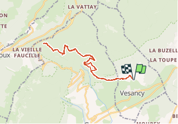
Tour Laufen von 17,8 km verfügbar auf Auvergne-Rhone-Alpen, Ain, Vesancy. Diese Tour wird von xekebo vorgeschlagen.
Beschreibung
Depuis Vesancy, prendre le sentier en direction de la forêt du Turet, prendre ensuite le chemin du creux du cerf puis la route du mauvais pas jusqu'au sommet. prendre ensuite en direction du col.
Ort
Land:
France
Region :
Auvergne-Rhone-Alpen
Abteilung/Provinz :
Ain
Kommune :
Vesancy
Standort:
Unknown
Gehen Sie:(Dec)
Gehen Sie:(UTM)
276087 ; 5137500 (32T) N.
Kommentare
Touren in der Umgebung
![Tour Wandern Divonne-les-Bains - 20230521 - Divonne-les-Bains 3.8 Km - Photo](https://media.geolcdn.com/t/375/260/c403e318-b319-4945-9f4d-5bdca807e739.jpg&format=jpg&maxdim=2)
![Wandern Wandern](https://static1.geolcdn.com/sitytour/trail-icons/101.png)
20230521 - Divonne-les-Bains 3.8 Km
Wandern
Einfach
Divonne-les-Bains,
Auvergne-Rhone-Alpen,
Ain,
France
![](/images/other/stat-length.png)
3,8 km | 4,1 km-effort
56min
![](https://static1.geolcdn.com/siteimages/upload/files/16400158638029165_repeat_loop_refresh_sync_direction_icon.png)
Ja
![Tour Wandern Divonne-les-Bains - Randonnée - Photo](https://media.geolcdn.com/t/375/260/a7642eff-af5a-4e85-88a6-d3c3280b1614.jpg&format=jpg&maxdim=2)
![Wandern Wandern](https://static1.geolcdn.com/sitytour/trail-icons/101.png)
Randonnée
Wandern
Medium
Divonne-les-Bains,
Auvergne-Rhone-Alpen,
Ain,
France
![](/images/other/stat-length.png)
6,2 km | 9 km-effort
2h 2min
![](https://static1.geolcdn.com/siteimages/upload/files/16400158638029165_repeat_loop_refresh_sync_direction_icon.png)
Ja
![Tour Wandern Gex - Le colomby de gex - Photo](https://media.geolcdn.com/t/375/260/ext.jpg?maxdim=2&url=https%3A%2F%2Fstatic1.geolcdn.com%2Fsiteimages%2Fupload%2Ffiles%2F1553511878bg_sport_marche.png)
![Wandern Wandern](https://static1.geolcdn.com/sitytour/trail-icons/101.png)
Le colomby de gex
Wandern
Schwierig
(1)
Gex,
Auvergne-Rhone-Alpen,
Ain,
France
![](/images/other/stat-length.png)
14 km | 24 km-effort
4h 30min
![](https://static1.geolcdn.com/siteimages/upload/files/16400158638029165_repeat_loop_refresh_sync_direction_icon.png)
Ja
![Tour Fahrrad Gex - Cyclo montagnarde : par les cols franco-suisse - Gex - Photo](https://media.geolcdn.com/t/375/260/ext.jpg?maxdim=2&url=https%3A%2F%2Fservices.sitytrail.com%2FGeolivesWS%2FDownloadMedia.ashx%3FTrailID%3D112824%26Media%3D12542_6.jpg)
![Fahrrad Fahrrad](https://static1.geolcdn.com/sitytour/trail-icons/200.png)
Cyclo montagnarde : par les cols franco-suisse - Gex
Fahrrad
Schwierig
Gex,
Auvergne-Rhone-Alpen,
Ain,
France
![](/images/other/stat-length.png)
61 km | 77 km-effort
4h 0min
![](https://static1.geolcdn.com/siteimages/upload/files/16400158638029165_repeat_loop_refresh_sync_direction_icon.png)
Ja
![Tour Fahrrad Gex - Les jardins de l'Europe - Version courte - Gex - Photo](https://media.geolcdn.com/t/375/260/ext.jpg?maxdim=2&url=https%3A%2F%2Fservices.sitytrail.com%2FGeolivesWS%2FDownloadMedia.ashx%3FTrailID%3D112823%26Media%3D12541_6.jpg)
![Fahrrad Fahrrad](https://static1.geolcdn.com/sitytour/trail-icons/200.png)
Les jardins de l'Europe - Version courte - Gex
Fahrrad
Medium
Gex,
Auvergne-Rhone-Alpen,
Ain,
France
![](/images/other/stat-length.png)
34 km | 40 km-effort
2h 0min
![](https://static1.geolcdn.com/siteimages/upload/files/16400158638029165_repeat_loop_refresh_sync_direction_icon.png)
Ja
![Tour Wintersport Mijoux - Piste de la Petite Grand (rouge - 10,5km ) - Photo](https://media.geolcdn.com/t/375/260/ext.jpg?maxdim=2&url=https%3A%2F%2Fservices.sitytrail.com%2FGeolivesWS%2FDownloadMedia.ashx%3FTrailID%3D30478%26Media%3Dimage5.jpg)
![Wintersport Wintersport](https://static1.geolcdn.com/sitytour/trail-icons/500.png)
Piste de la Petite Grand (rouge - 10,5km )
Wintersport
Sehr leicht
Mijoux,
Auvergne-Rhone-Alpen,
Ain,
France
![](/images/other/stat-length.png)
9,6 km | 12,4 km-effort
2h 0min
![](https://static1.geolcdn.com/siteimages/upload/files/16400158638029165_repeat_loop_refresh_sync_direction_icon.png)
Ja
![Tour Wandern Gex - morilles et st georges - Photo](https://media.geolcdn.com/t/375/260/fcbda1d7-6fb3-4ff6-8c4a-4598db0f67d2.jpg&format=jpg&maxdim=2)
![Wandern Wandern](https://static1.geolcdn.com/sitytour/trail-icons/101.png)
morilles et st georges
Wandern
Sehr schwierig
Gex,
Auvergne-Rhone-Alpen,
Ain,
France
![](/images/other/stat-length.png)
55 km | 66 km-effort
2h 56min
![](https://static1.geolcdn.com/siteimages/upload/files/16400158638029165_repeat_loop_refresh_sync_direction_icon.png)
Ja
![Tour Wandern Gex - Colomby de Gex - Photo](https://media.geolcdn.com/t/375/260/36a62d8e-b074-4d84-8146-c8e1c82236e8.jpg&format=jpg&maxdim=2)
![Wandern Wandern](https://static1.geolcdn.com/sitytour/trail-icons/101.png)
Colomby de Gex
Wandern
Medium
Gex,
Auvergne-Rhone-Alpen,
Ain,
France
![](/images/other/stat-length.png)
19,2 km | 31 km-effort
5h 51min
![](https://static1.geolcdn.com/siteimages/upload/files/16400158638029165_repeat_loop_refresh_sync_direction_icon.png)
Nein
![Tour sport Vesancy - Prospection morilles - Photo](https://media.geolcdn.com/t/375/260/fa5962c4-e0f0-468a-b502-7654a3ad4512.jpg&format=jpg&maxdim=2)
Prospection morilles
sport
Sehr leicht
Vesancy,
Auvergne-Rhone-Alpen,
Ain,
France
![](/images/other/stat-length.png)
4,8 km | 7,2 km-effort
Unbekannt
![](https://static1.geolcdn.com/siteimages/upload/files/16400158638029165_repeat_loop_refresh_sync_direction_icon.png)
Nein