![](/images/other/stat-length.png)
![Tour Wandern Carolles - Projet Champeaux Falaises et Arrière pays - Photo](https://media.geolcdn.com/t/1900/400/ext.pjpeg?maxdim=2&url=https%3A%2F%2Fstatic1.geolcdn.com%2Fsiteimages%2Fupload%2Ffiles%2F1553511878bg_sport_marche.png)
Projet Champeaux Falaises et Arrière pays
mousetik
Benutzer
![Länge](/images/other/stat-length.png)
Länge
14,1 km
![Maximale Höhe](https://static1.geolcdn.com/siteimages/upload/files/1508320355ic_sort_altitude_max_24dp.png)
Maximale Höhe
102 m
![Positive Höhendifferenz](https://static1.geolcdn.com/siteimages/upload/files/1508320355ic_sort_den_pos_24dp.png)
Positive Höhendifferenz
223 m
![Km-Effort](/images/other/stat-length.png)
Km-Effort
17,1 km
![Min. Höhe](https://static1.geolcdn.com/siteimages/upload/files/1508320355ic_sort_altitude_min_24dp.png)
Min. Höhe
11 m
![Negative Höhendifferenz](https://static1.geolcdn.com/siteimages/upload/files/1508320355ic_sort_den_neg_24dp.png)
Negative Höhendifferenz
217 m
![Boucle](https://static1.geolcdn.com/siteimages/upload/files/16400158638029165_repeat_loop_refresh_sync_direction_icon.png)
Boucle
Ja
Erstellungsdatum :
2014-12-10 00:00:00.0
Letzte Änderung :
2014-12-10 00:00:00.0
![Wandern](https://static1.geolcdn.com/sitytour/trail-icons/101.png)
--
Schwierigkeit : Medium
![Scannen Sie diesen QR-Code, um die Tour in der SityTrail-Anwendung zu öffnen](https://capi.geolives.com/qq0zvz2zws4bq2lad0pu/sitytour/trails/119706/qr.png?size=200)
Kostenlosegpshiking-Anwendung
Über SityTrail
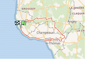
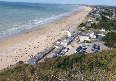
Tour Wandern von 14,1 km verfügbar auf Normandie, Manche, Carolles. Diese Tour wird von mousetik vorgeschlagen.
Beschreibung
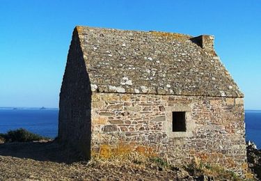
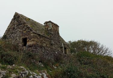
Départ Parking Cabane Vauban
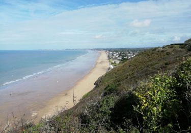
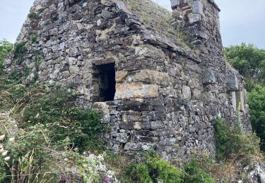
Chemin des douaniers jusqu'à Saint Jean Le Thomas
Remontée dans l'arrière pays de Champeaux et de Carolles
Retour au parking
Ort
Land:
France
Region :
Normandie
Abteilung/Provinz :
Manche
Kommune :
Carolles
Standort:
Unknown
Gehen Sie:(Dec)
Gehen Sie:(UTM)
605419 ; 5399854 (30U) N.
Kommentare
Touren in der Umgebung
![Tour Wandern Carolles - La Vallée du Lude - Carolles - Photo](https://media.geolcdn.com/t/375/260/ext.jpg?maxdim=2&url=https%3A%2F%2Fservices.sitytrail.com%2FGeolivesWS%2FDownloadMedia.ashx%3FTrailID%3D111207%26Media%3D6732_2.jpg)
![Wandern Wandern](https://static1.geolcdn.com/sitytour/trail-icons/101.png)
La Vallée du Lude - Carolles
Wandern
Medium
(1)
Carolles,
Normandie,
Manche,
France
![](/images/other/stat-length.png)
6,7 km | 8,6 km-effort
2h 30min
![](https://static1.geolcdn.com/siteimages/upload/files/16400158638029165_repeat_loop_refresh_sync_direction_icon.png)
Nein
![Tour Wandern Carolles - Falaises de Carolles - Photo](https://media.geolcdn.com/t/375/260/5d1fc960-65ea-42db-9e46-60d9d0864366.jpg&format=jpg&maxdim=2)
![Wandern Wandern](https://static1.geolcdn.com/sitytour/trail-icons/101.png)
Falaises de Carolles
Wandern
Sehr leicht
Carolles,
Normandie,
Manche,
France
![](/images/other/stat-length.png)
4,1 km | 5,4 km-effort
1h 6min
![](https://static1.geolcdn.com/siteimages/upload/files/16400158638029165_repeat_loop_refresh_sync_direction_icon.png)
Ja
![Tour Wandern Champeaux - les falaises de Carolles - Champeaux - Photo](https://media.geolcdn.com/t/375/260/b4018617-2a83-4486-b109-eba5df37275a.jpg&format=jpg&maxdim=2)
![Wandern Wandern](https://static1.geolcdn.com/sitytour/trail-icons/101.png)
les falaises de Carolles - Champeaux
Wandern
Medium
Champeaux,
Normandie,
Manche,
France
![](/images/other/stat-length.png)
8,6 km | 10,9 km-effort
2h 13min
![](https://static1.geolcdn.com/siteimages/upload/files/16400158638029165_repeat_loop_refresh_sync_direction_icon.png)
Ja
![Tour Wandern Carolles - Carolle-plage--Cabane Vauban - Photo](https://media.geolcdn.com/t/375/260/a1294c86-a38d-47df-96a5-f6a609fcfeb5.jpg&format=jpg&maxdim=2)
![Wandern Wandern](https://static1.geolcdn.com/sitytour/trail-icons/101.png)
Carolle-plage--Cabane Vauban
Wandern
Medium
Carolles,
Normandie,
Manche,
France
![](/images/other/stat-length.png)
5,9 km | 7,8 km-effort
3h 0min
![](https://static1.geolcdn.com/siteimages/upload/files/16400158638029165_repeat_loop_refresh_sync_direction_icon.png)
Ja
![Tour Wandern Champeaux - La cabane Vauban et ses falaises - Photo](https://media.geolcdn.com/t/375/260/0537bf9f-7396-4153-894c-ff80f4b1c8c9.jpg&format=jpg&maxdim=2)
![Wandern Wandern](https://static1.geolcdn.com/sitytour/trail-icons/101.png)
La cabane Vauban et ses falaises
Wandern
Medium
Champeaux,
Normandie,
Manche,
France
![](/images/other/stat-length.png)
7,9 km | 9,5 km-effort
2h 54min
![](https://static1.geolcdn.com/siteimages/upload/files/16400158638029165_repeat_loop_refresh_sync_direction_icon.png)
Ja
![Tour Wandern Carolles - carolles 2 Françoise Chan - Photo](https://media.geolcdn.com/t/375/260/84d08c68-e3bb-40fc-8c58-d13ee2f789eb.jpg&format=jpg&maxdim=2)
![Wandern Wandern](https://static1.geolcdn.com/sitytour/trail-icons/101.png)
carolles 2 Françoise Chan
Wandern
Medium
Carolles,
Normandie,
Manche,
France
![](/images/other/stat-length.png)
8,5 km | 10,6 km-effort
2h 50min
![](https://static1.geolcdn.com/siteimages/upload/files/16400158638029165_repeat_loop_refresh_sync_direction_icon.png)
Ja
![Tour Nordic Walking Carolles - Carolles 7 km chantal Françoise - Photo](https://media.geolcdn.com/t/375/260/511e2612-50d0-4984-9fe7-21900970065f.jpg&format=jpg&maxdim=2)
![Nordic Walking Nordic Walking](https://static1.geolcdn.com/sitytour/trail-icons/102.png)
Carolles 7 km chantal Françoise
Nordic Walking
Sehr leicht
Carolles,
Normandie,
Manche,
France
![](/images/other/stat-length.png)
7 km | 9,3 km-effort
2h 33min
![](https://static1.geolcdn.com/siteimages/upload/files/16400158638029165_repeat_loop_refresh_sync_direction_icon.png)
Ja
![Tour Wandern Jullouville - Jullouville - Carolles - Photo](https://media.geolcdn.com/t/375/260/7a08b560-2c53-4e14-8982-7e1346600440.jpg&format=jpg&maxdim=2)
![Wandern Wandern](https://static1.geolcdn.com/sitytour/trail-icons/101.png)
Jullouville - Carolles
Wandern
Medium
Jullouville,
Normandie,
Manche,
France
![](/images/other/stat-length.png)
7,4 km | 8,6 km-effort
2h 4min
![](https://static1.geolcdn.com/siteimages/upload/files/16400158638029165_repeat_loop_refresh_sync_direction_icon.png)
Nein
![Tour Wandern Dragey-Ronthon - Le Bec d’Andaine - Photo](https://media.geolcdn.com/t/375/260/9bab126b-7d02-49a6-a8e6-abf4befe4e3f.jpg&format=jpg&maxdim=2)
![Wandern Wandern](https://static1.geolcdn.com/sitytour/trail-icons/101.png)
Le Bec d’Andaine
Wandern
Einfach
Dragey-Ronthon,
Normandie,
Manche,
France
![](/images/other/stat-length.png)
10,2 km | 11,2 km-effort
3h 1min
![](https://static1.geolcdn.com/siteimages/upload/files/16400158638029165_repeat_loop_refresh_sync_direction_icon.png)
Ja