![](/images/other/stat-length.png)
![Tour Wandern Entre-Vignes - Les Croix de Saint Christol - Photo](https://media.geolcdn.com/t/1900/400/ext.pjpeg?maxdim=2&url=https%3A%2F%2Fservices.sitytrail.com%2FGeolivesWS%2FDownloadMedia.ashx%3FTrailID%3D118860%26Media%3D13076_3.jpg)
Les Croix de Saint Christol
tracegps
Benutzer
![Länge](/images/other/stat-length.png)
Länge
7,7 km
![Maximale Höhe](https://static1.geolcdn.com/siteimages/upload/files/1508320355ic_sort_altitude_max_24dp.png)
Maximale Höhe
78 m
![Positive Höhendifferenz](https://static1.geolcdn.com/siteimages/upload/files/1508320355ic_sort_den_pos_24dp.png)
Positive Höhendifferenz
93 m
![Km-Effort](/images/other/stat-length.png)
Km-Effort
9 km
![Min. Höhe](https://static1.geolcdn.com/siteimages/upload/files/1508320355ic_sort_altitude_min_24dp.png)
Min. Höhe
35 m
![Negative Höhendifferenz](https://static1.geolcdn.com/siteimages/upload/files/1508320355ic_sort_den_neg_24dp.png)
Negative Höhendifferenz
94 m
![Boucle](https://static1.geolcdn.com/siteimages/upload/files/16400158638029165_repeat_loop_refresh_sync_direction_icon.png)
Boucle
Ja
Erstellungsdatum :
2014-12-10 00:00:00.0
Letzte Änderung :
2014-12-10 00:00:00.0
![Wandern](https://static1.geolcdn.com/sitytour/trail-icons/101.png)
1h30
Schwierigkeit : Medium
![Scannen Sie diesen QR-Code, um die Tour in der SityTrail-Anwendung zu öffnen](https://capi.geolives.com/qq0zvz2zws4bq2lad0pu/sitytour/trails/118860/qr.png?size=200)
Kostenlosegpshiking-Anwendung
Über SityTrail
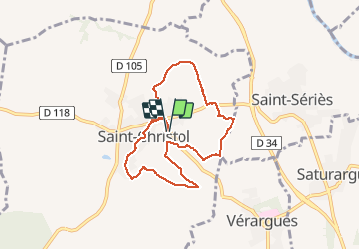
Tour Wandern von 7,7 km verfügbar auf Okzitanien, Hérault, Entre-Vignes. Diese Tour wird von tracegps vorgeschlagen.
Beschreibung
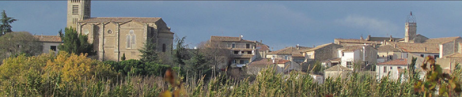
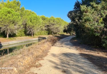
Randonnée à travers les vignes, sans grande difficulté. Elle est jalonnée de nombreuses croix, certaines étant le départ de processions. De belles vues sur l'Hortus et le Pic Saint Loup. Voir aussi le circuit n°8863.
Ort
Land:
France
Region :
Okzitanien
Abteilung/Provinz :
Hérault
Kommune :
Entre-Vignes
Standort:
Saint-Christol
Gehen Sie:(Dec)
Gehen Sie:(UTM)
587304 ; 4842196 (31T) N.
Kommentare
Touren in der Umgebung
![Tour Wandern Saussines - Saussines - Photo](https://media.geolcdn.com/t/375/260/ext.jpg?maxdim=2&url=https%3A%2F%2Fstatic1.geolcdn.com%2Fsiteimages%2Fupload%2Ffiles%2F1553511878bg_sport_marche.png)
![Wandern Wandern](https://static1.geolcdn.com/sitytour/trail-icons/101.png)
Saussines
Wandern
Sehr leicht
(1)
Saussines,
Okzitanien,
Hérault,
France
![](/images/other/stat-length.png)
13,3 km | 14,9 km-effort
4h 13min
![](https://static1.geolcdn.com/siteimages/upload/files/16400158638029165_repeat_loop_refresh_sync_direction_icon.png)
Ja
![Tour Wandern Saint-Geniès-des-Mourgues - 30 beaulieu - Photo](https://media.geolcdn.com/t/375/260/e48acc05-ba85-4785-a34a-e2be2133d057.jpg&format=jpg&maxdim=2)
![Wandern Wandern](https://static1.geolcdn.com/sitytour/trail-icons/101.png)
30 beaulieu
Wandern
Sehr leicht
Saint-Geniès-des-Mourgues,
Okzitanien,
Hérault,
France
![](/images/other/stat-length.png)
11,5 km | 13,3 km-effort
4h 57min
![](https://static1.geolcdn.com/siteimages/upload/files/16400158638029165_repeat_loop_refresh_sync_direction_icon.png)
Ja
![Tour Wandern Saussines - Circuit des capot elles - Photo](https://media.geolcdn.com/t/375/260/6f4a9959-1f02-425b-b581-c3419555dbfc.jpg&format=jpg&maxdim=2)
![Wandern Wandern](https://static1.geolcdn.com/sitytour/trail-icons/101.png)
Circuit des capot elles
Wandern
Schwierig
Saussines,
Okzitanien,
Hérault,
France
![](/images/other/stat-length.png)
11,7 km | 13,4 km-effort
3h 56min
![](https://static1.geolcdn.com/siteimages/upload/files/16400158638029165_repeat_loop_refresh_sync_direction_icon.png)
Ja
![Tour Elektrofahrrad Junas - Boucle de la Vidourle - Photo](https://media.geolcdn.com/t/375/260/bfea6d61-9a81-4c7f-8a65-551fef99e67d.jpg&format=jpg&maxdim=2)
![Elektrofahrrad Elektrofahrrad](https://static1.geolcdn.com/sitytour/trail-icons/205.png)
Boucle de la Vidourle
Elektrofahrrad
Einfach
Junas,
Okzitanien,
Gard,
France
![](/images/other/stat-length.png)
38 km | 43 km-effort
2h 33min
![](https://static1.geolcdn.com/siteimages/upload/files/16400158638029165_repeat_loop_refresh_sync_direction_icon.png)
Ja
![Tour Wandern Junas - Aubais - Photo](https://media.geolcdn.com/t/375/260/6d98e84b-2918-432b-a42a-3fc4dbb2b5a1.jpeg&format=jpg&maxdim=2)
![Wandern Wandern](https://static1.geolcdn.com/sitytour/trail-icons/101.png)
![Tour Wandern Saussines - Saussines et ses capitelles - Photo](https://media.geolcdn.com/t/375/260/0e3f4dc9-b3d2-4dd3-b56c-054def4dec10.jpg&format=jpg&maxdim=2)
![Wandern Wandern](https://static1.geolcdn.com/sitytour/trail-icons/101.png)
Saussines et ses capitelles
Wandern
Medium
Saussines,
Okzitanien,
Hérault,
France
![](/images/other/stat-length.png)
10,3 km | 11,6 km-effort
2h 37min
![](https://static1.geolcdn.com/siteimages/upload/files/16400158638029165_repeat_loop_refresh_sync_direction_icon.png)
Ja
![Tour Wandern Lunel - lunel_tour_de_farge - Photo](https://media.geolcdn.com/t/375/260/b70d97a3-9eda-4743-80e9-10a2f0f582c3.jpg&format=jpg&maxdim=2)
![Wandern Wandern](https://static1.geolcdn.com/sitytour/trail-icons/101.png)
lunel_tour_de_farge
Wandern
Medium
Lunel,
Okzitanien,
Hérault,
France
![](/images/other/stat-length.png)
13,4 km | 15,4 km-effort
3h 30min
![](https://static1.geolcdn.com/siteimages/upload/files/16400158638029165_repeat_loop_refresh_sync_direction_icon.png)
Ja
![Tour Wandern Saussines - Saussine, sentier des Romains - Photo](https://media.geolcdn.com/t/375/260/0836bc44-bd2a-4d13-93c8-7797a8f68ea7.jpg&format=jpg&maxdim=2)
![Wandern Wandern](https://static1.geolcdn.com/sitytour/trail-icons/101.png)
Saussine, sentier des Romains
Wandern
Sehr leicht
(1)
Saussines,
Okzitanien,
Hérault,
France
![](/images/other/stat-length.png)
12,2 km | 14 km-effort
3h 32min
![](https://static1.geolcdn.com/siteimages/upload/files/16400158638029165_repeat_loop_refresh_sync_direction_icon.png)
Ja
![Tour Wandern Saussines - Saussines Les Capitelles de la Benovie - Photo](https://media.geolcdn.com/t/375/260/fdb3b940-9103-456c-b077-11ff4f962f60.jpg&format=jpg&maxdim=2)
![Wandern Wandern](https://static1.geolcdn.com/sitytour/trail-icons/101.png)
Saussines Les Capitelles de la Benovie
Wandern
Medium
Saussines,
Okzitanien,
Hérault,
France
![](/images/other/stat-length.png)
10 km | 11,3 km-effort
4h 48min
![](https://static1.geolcdn.com/siteimages/upload/files/16400158638029165_repeat_loop_refresh_sync_direction_icon.png)
Ja
Le tracé est obsolète. La trace traverse perpendiculairement des lignes de vigne. Il y a par contre moyen de faire la rando moyennant quelques détours