![](/images/other/stat-length.png)
![Tour Mountainbike Neulise - VTT Sportif à Neulise - Photo](https://media.geolcdn.com/t/1900/400/ext.pjpeg?maxdim=2&url=https%3A%2F%2Fservices.sitytrail.com%2FGeolivesWS%2FDownloadMedia.ashx%3FTrailID%3D118839%26Media%3D13054_6.jpg)
VTT Sportif à Neulise
tracegps
Benutzer
![Länge](/images/other/stat-length.png)
![Maximale Höhe](https://static1.geolcdn.com/siteimages/upload/files/1508320355ic_sort_altitude_max_24dp.png)
![Positive Höhendifferenz](https://static1.geolcdn.com/siteimages/upload/files/1508320355ic_sort_den_pos_24dp.png)
![Km-Effort](/images/other/stat-length.png)
![Min. Höhe](https://static1.geolcdn.com/siteimages/upload/files/1508320355ic_sort_altitude_min_24dp.png)
![Negative Höhendifferenz](https://static1.geolcdn.com/siteimages/upload/files/1508320355ic_sort_den_neg_24dp.png)
![Boucle](https://static1.geolcdn.com/siteimages/upload/files/16400158638029165_repeat_loop_refresh_sync_direction_icon.png)
![Mountainbike](https://static1.geolcdn.com/sitytour/trail-icons/202.png)
3h00
Schwierigkeit : Schwierig
![Scannen Sie diesen QR-Code, um die Tour in der SityTrail-Anwendung zu öffnen](https://capi.geolives.com/qq0zvz2zws4bq2lad0pu/sitytour/trails/118839/qr.png?size=200)
Kostenlosegpshiking-Anwendung
Über SityTrail
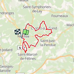
Tour Mountainbike von 28 km verfügbar auf Auvergne-Rhone-Alpen, Loire, Neulise. Diese Tour wird von tracegps vorgeschlagen.
Beschreibung
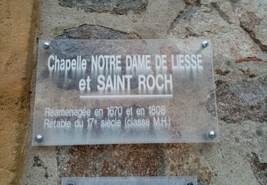
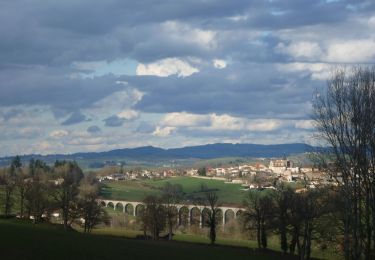
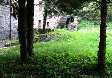
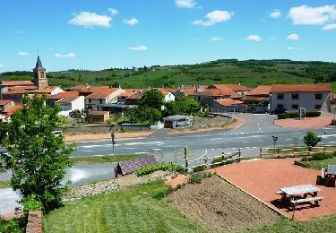
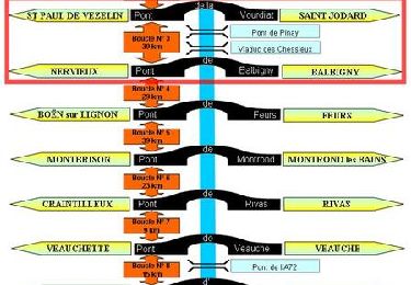
Parking est départ de la salle polyvalente (direction Pinay). C'est un très beau parcours de VTT qui emprunte principalement des portions des circuits de la Communauté de Communes du Pays entre Loire et Rhône (CoPLER). Pas beaucoup de technique, mais peu de répit sur ce circuit très rythmé et ludique qui ne fait que monter et descendre. Sur les hauteurs de très beaux points de vue sur les massifs et villages des alentours. Traversée de ruisseaux et de sous bois, un dépaysement total et quelle tranquillité. Eviter de faire cette boucle par terrain gras. Au départ de Neulise, il existe également un circuit VTT de 10 km (balisage rouge E3) proposé par l'office de tourisme des Montagnes du Matin. Topo-guides : Guide des Randonnées du "Pays entre Loire et Rhône" (32 circuits) édité par la Communauté de Communes du Pays entre Loire et Rhône (CoPLER) ; Les Montagnes du Matin - Randonnée Pédestre (54 circuits) et les Montagnes du Matin - Réseau VTT (27 circuits, selon le secteur - lettres A, B, C, D, E).
Ort
Kommentare
Touren in der Umgebung
![Tour Wandern Pinay - Autour des Gorges de la Loire - GR Pays N° 5 : De la Digue à La Vourdiat - La Digue de Pinay - Photo](https://media.geolcdn.com/t/375/260/ext.jpg?maxdim=2&url=https%3A%2F%2Fservices.sitytrail.com%2FGeolivesWS%2FDownloadMedia.ashx%3FTrailID%3D215012%26Media%3D15578_6.jpg)
![Wandern Wandern](https://static1.geolcdn.com/sitytour/trail-icons/101.png)
Wandern
![](/images/other/stat-length.png)
![](https://static1.geolcdn.com/siteimages/upload/files/16400158638029165_repeat_loop_refresh_sync_direction_icon.png)
![Tour Wandern Saint-Symphorien-de-Lay - etang st symphorien de lay - Photo](https://media.geolcdn.com/t/375/260/ext.jpg?maxdim=2&url=https%3A%2F%2Fstatic1.geolcdn.com%2Fsiteimages%2Fupload%2Ffiles%2F1553511878bg_sport_marche.png)
![Wandern Wandern](https://static1.geolcdn.com/sitytour/trail-icons/101.png)
Wandern
![](/images/other/stat-length.png)
![](https://static1.geolcdn.com/siteimages/upload/files/16400158638029165_repeat_loop_refresh_sync_direction_icon.png)
![Tour Wandern Saint-Symphorien-de-Lay - St Symphorien de lay, agri rando - Photo](https://media.geolcdn.com/t/375/260/ad65c851-00cb-4ac7-9236-117ab0c718e4.jpg&format=jpg&maxdim=2)
![Wandern Wandern](https://static1.geolcdn.com/sitytour/trail-icons/101.png)
Wandern
![](/images/other/stat-length.png)
![](https://static1.geolcdn.com/siteimages/upload/files/16400158638029165_repeat_loop_refresh_sync_direction_icon.png)
![Tour Wandern Saint-Just-la-Pendue - St Just la Pendue, départ à la chapelle - Photo](https://media.geolcdn.com/t/375/260/d9e557db-285e-474a-a80e-c32ca6be6af3.jpg&format=jpg&maxdim=2)
![Wandern Wandern](https://static1.geolcdn.com/sitytour/trail-icons/101.png)
Wandern
![](/images/other/stat-length.png)
![](https://static1.geolcdn.com/siteimages/upload/files/16400158638029165_repeat_loop_refresh_sync_direction_icon.png)
![Tour Wandern Saint-Marcel-de-Félines - rando à partir de St Marcel les Felines - Photo](https://media.geolcdn.com/t/375/260/25de8710-609c-4277-bb5d-14bd81d5616d.jpg&format=jpg&maxdim=2)
![Wandern Wandern](https://static1.geolcdn.com/sitytour/trail-icons/101.png)
Wandern
![](/images/other/stat-length.png)
![](https://static1.geolcdn.com/siteimages/upload/files/16400158638029165_repeat_loop_refresh_sync_direction_icon.png)
![Wandern Wandern](https://static1.geolcdn.com/sitytour/trail-icons/101.png)
Wandern
![](/images/other/stat-length.png)
![](https://static1.geolcdn.com/siteimages/upload/files/16400158638029165_repeat_loop_refresh_sync_direction_icon.png)
![Tour Wandern Saint-Marcel-de-Félines - St Marcel de Félines - Photo](https://media.geolcdn.com/t/375/260/ext.jpg?maxdim=2&url=https%3A%2F%2Fservices.sitytrail.com%2FGeolivesWS%2FDownloadMedia.ashx%3FTrailID%3D369342%26Media%3D20141007152007.jpg)
![Wandern Wandern](https://static1.geolcdn.com/sitytour/trail-icons/101.png)
Wandern
![](/images/other/stat-length.png)
![](https://static1.geolcdn.com/siteimages/upload/files/16400158638029165_repeat_loop_refresh_sync_direction_icon.png)
![Tour Wandern Vendranges - 29ème Randonnée des Vadrouillards (Grand circuit) - Vendranges - Photo](https://media.geolcdn.com/t/375/260/ext.jpg?maxdim=2&url=https%3A%2F%2Fservices.sitytrail.com%2FGeolivesWS%2FDownloadMedia.ashx%3FTrailID%3D317942%26Media%3D17373_6.jpg)
![Wandern Wandern](https://static1.geolcdn.com/sitytour/trail-icons/101.png)
Wandern
![](/images/other/stat-length.png)
![](https://static1.geolcdn.com/siteimages/upload/files/16400158638029165_repeat_loop_refresh_sync_direction_icon.png)
![Tour Mountainbike Saint-Jodard - Du Barrage de Villerest au Barrage de Grangent en 10 boucles / Boucle N° 03 : Pont de La Vourdiat - Pont de Balbigny - Photo](https://media.geolcdn.com/t/375/260/ext.jpg?maxdim=2&url=https%3A%2F%2Fservices.sitytrail.com%2FGeolivesWS%2FDownloadMedia.ashx%3FTrailID%3D316880%26Media%3D15964_6.jpg)
![Mountainbike Mountainbike](https://static1.geolcdn.com/sitytour/trail-icons/202.png)
Mountainbike
![](/images/other/stat-length.png)
![](https://static1.geolcdn.com/siteimages/upload/files/16400158638029165_repeat_loop_refresh_sync_direction_icon.png)