![](/images/other/stat-length.png)
![Tour Wandern Saint-Sauvier - Circuit de la chapelle Saint Rémi - Saint Sauvier - Photo](https://media.geolcdn.com/t/1900/400/ext.pjpeg?maxdim=2&url=https%3A%2F%2Fservices.sitytrail.com%2FGeolivesWS%2FDownloadMedia.ashx%3FTrailID%3D118832%26Media%3D13046_6.jpg)
Circuit de la chapelle Saint Rémi - Saint Sauvier
tracegps
Benutzer
![Länge](/images/other/stat-length.png)
![Maximale Höhe](https://static1.geolcdn.com/siteimages/upload/files/1508320355ic_sort_altitude_max_24dp.png)
![Positive Höhendifferenz](https://static1.geolcdn.com/siteimages/upload/files/1508320355ic_sort_den_pos_24dp.png)
![Km-Effort](/images/other/stat-length.png)
![Min. Höhe](https://static1.geolcdn.com/siteimages/upload/files/1508320355ic_sort_altitude_min_24dp.png)
![Negative Höhendifferenz](https://static1.geolcdn.com/siteimages/upload/files/1508320355ic_sort_den_neg_24dp.png)
![Boucle](https://static1.geolcdn.com/siteimages/upload/files/16400158638029165_repeat_loop_refresh_sync_direction_icon.png)
![Wandern](https://static1.geolcdn.com/sitytour/trail-icons/101.png)
2h19
Schwierigkeit : Medium
![Scannen Sie diesen QR-Code, um die Tour in der SityTrail-Anwendung zu öffnen](https://capi.geolives.com/qq0zvz2zws4bq2lad0pu/sitytour/trails/118832/qr.png?size=200)
Kostenlosegpshiking-Anwendung
Über SityTrail
Tour Wandern von 9,5 km verfügbar auf Auvergne-Rhone-Alpen, Allier, Saint-Sauvier. Diese Tour wird von tracegps vorgeschlagen.
Beschreibung
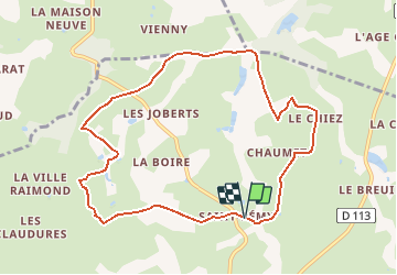
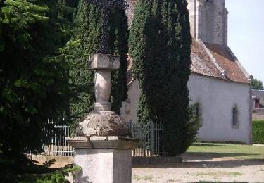
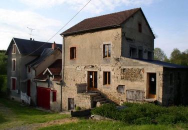
Ce circuit vous est proposé par la Communauté de communes du Pays d'Huriel, Si vous désirez un support papier, il est disponible à la Communauté de Communes ou au Point Info Tourisme pour 2 €. Il comprend le descriptif des circuits et chemins de liaison ainsi que les cartes. Départ devant la chapelle Saint Rémy. Prendre le 1er chemin à gauche en direction de « Chaumet » et le suivre jusqu’à la route. La traverser et prendre en face en direction de « Le Chiez ». Traverser le lieu-dit. Prendre le 1er chemin à gauche, faire 500 m puis le 1er chemin à droite. Descendre le chemin sur 1 km pour rejoindre la rivière. Longer les ruines du « Moulin de Ferrand » (pour les attelages, il y a une petite déviation en continuant le chemin principal puis en redescendant sur la droite). Prendre le 1er chemin à droite dans les bois en direction de « Le Patouiller ». Continuer tout droit jusqu’à la route et la traverser. Arrivé à un croisement de 4 chemins, prendre celui de gauche puis le 1er à droite qui longe la carrière de « La Goutte Chave ». Après celle-ci, tourner dans le 1er chemin à gauche qui rejoint une route. Tourner à gauche à la route, de nouveau à gauche dans le 1er chemin puis à droite. Continuer tout droit pour retourner à la chapelle Saint Rémy.
Ort
Kommentare
Touren in der Umgebung
![Tour Wandern Mesples - Sur les pas des Maîtres Sonneurs (Mesples - Huriel) - Photo](https://media.geolcdn.com/t/375/260/ext.jpg?maxdim=2&url=https%3A%2F%2Fservices.sitytrail.com%2FGeolivesWS%2FDownloadMedia.ashx%3FTrailID%3D172463%26Media%3D13823_3.jpg)
![Wandern Wandern](https://static1.geolcdn.com/sitytour/trail-icons/101.png)
Wandern
![](/images/other/stat-length.png)
![](https://static1.geolcdn.com/siteimages/upload/files/16400158638029165_repeat_loop_refresh_sync_direction_icon.png)
![Tour Wandern Saint-Palais - Circuit des 3 régions - Saint Palais - Photo](https://media.geolcdn.com/t/375/260/ext.jpg?maxdim=2&url=https%3A%2F%2Fservices.sitytrail.com%2FGeolivesWS%2FDownloadMedia.ashx%3FTrailID%3D118823%26Media%3D13035_5.jpg)
![Wandern Wandern](https://static1.geolcdn.com/sitytour/trail-icons/101.png)
Wandern
![](/images/other/stat-length.png)
![](https://static1.geolcdn.com/siteimages/upload/files/16400158638029165_repeat_loop_refresh_sync_direction_icon.png)
![Tour Wandern Mesples - Circuit du moulin - Mesples - Photo](https://media.geolcdn.com/t/375/260/ext.jpg?maxdim=2&url=https%3A%2F%2Fservices.sitytrail.com%2FGeolivesWS%2FDownloadMedia.ashx%3FTrailID%3D118810%26Media%3D13018_6.jpg)
![Wandern Wandern](https://static1.geolcdn.com/sitytour/trail-icons/101.png)
Wandern
![](/images/other/stat-length.png)
![](https://static1.geolcdn.com/siteimages/upload/files/16400158638029165_repeat_loop_refresh_sync_direction_icon.png)
![Tour Mountainbike Mesples - MESPLES PREVERANGES - Photo](https://media.geolcdn.com/t/375/260/ext.jpg?maxdim=2&url=https%3A%2F%2Fstatic1.geolcdn.com%2Fsiteimages%2Fupload%2Ffiles%2F1524743154velo.jpg)
![Mountainbike Mountainbike](https://static1.geolcdn.com/sitytour/trail-icons/202.png)
Mountainbike
![](/images/other/stat-length.png)
![](https://static1.geolcdn.com/siteimages/upload/files/16400158638029165_repeat_loop_refresh_sync_direction_icon.png)
![Tour Wandern Leyrat - Circuit de Longchamp - Photo](https://media.geolcdn.com/t/375/260/ext.jpg?maxdim=2&url=https%3A%2F%2Fstatic1.geolcdn.com%2Fsiteimages%2Fupload%2Ffiles%2F1553511878bg_sport_marche.png)
![Wandern Wandern](https://static1.geolcdn.com/sitytour/trail-icons/101.png)
Wandern
![](/images/other/stat-length.png)
![](https://static1.geolcdn.com/siteimages/upload/files/16400158638029165_repeat_loop_refresh_sync_direction_icon.png)
Juste ce que je cherchais. Cartes de rando nickel, app rapide.