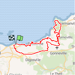
![](/images/other/stat-length.png)
![Tour Mountainbike Cherbourg-en-Cotentin - VTT Interclubs du Cotentin 2012 - Tourlaville - Photo](https://media.geolcdn.com/t/1900/400/ext.pjpeg?maxdim=2&url=https%3A%2F%2Fservices.sitytrail.com%2FGeolivesWS%2FDownloadMedia.ashx%3FTrailID%3D118825%26Media%3D13037_1.jpg)
VTT Interclubs du Cotentin 2012 - Tourlaville
tracegps
Benutzer
![Länge](/images/other/stat-length.png)
![Maximale Höhe](https://static1.geolcdn.com/siteimages/upload/files/1508320355ic_sort_altitude_max_24dp.png)
![Positive Höhendifferenz](https://static1.geolcdn.com/siteimages/upload/files/1508320355ic_sort_den_pos_24dp.png)
![Km-Effort](/images/other/stat-length.png)
![Min. Höhe](https://static1.geolcdn.com/siteimages/upload/files/1508320355ic_sort_altitude_min_24dp.png)
![Negative Höhendifferenz](https://static1.geolcdn.com/siteimages/upload/files/1508320355ic_sort_den_neg_24dp.png)
![Boucle](https://static1.geolcdn.com/siteimages/upload/files/16400158638029165_repeat_loop_refresh_sync_direction_icon.png)
![Mountainbike](https://static1.geolcdn.com/sitytour/trail-icons/202.png)
3h00
Schwierigkeit : Medium
![Scannen Sie diesen QR-Code, um die Tour in der SityTrail-Anwendung zu öffnen](https://capi.geolives.com/qq0zvz2zws4bq2lad0pu/sitytour/trails/118825/qr.png?size=200)
Kostenlosegpshiking-Anwendung
Über SityTrail
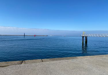
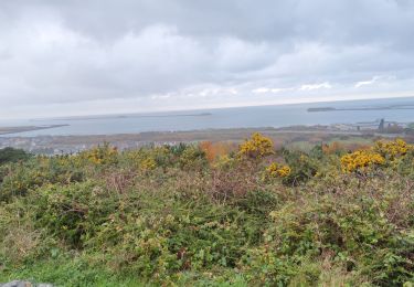
Tour Mountainbike von 33 km verfügbar auf Normandie, Manche, Cherbourg-en-Cotentin. Diese Tour wird von tracegps vorgeschlagen.
Beschreibung
Circuit est concocté par le NCMTB lors de notre rassemblement annuel. Il est composé de chemins carrossés, de singles, de passages entre les arbres de petits sentiers entre les haies et de chemins caillouteux. Très varié, idéal pour découvrir le secteur autrement que par la route. LES HAGUARDS vous donnent rendez-vous tous les dimanches si, comme nous, vous appréciez les randos dans une ambiance conviviale et sportive (nous formons plusieurs groupes de niveaux différents). LES HAGUARDS ne sont pas sectaires et apprécient aussi de pratiquer d'autres activités sportives telles que les raids multisports, trails, triathlons etc........ LES HAGUARDS n'hésitent pas à se déplacer ensembles sur des évènements incontournables comme la GAMELLE TROPHY, LA JEAN RACINE, LA FORESTIERE etc......
Ort
Kommentare
Touren in der Umgebung
![Tour Zu Fuß Cherbourg-en-Cotentin - Séjour Cotentin Etape 7 Boucle Cherbourg avant départ - Photo](https://media.geolcdn.com/t/375/260/ecdd6e0d-0f77-43a1-9488-9c5e48720411.jpg&format=jpg&maxdim=2)
![Zu Fuß Zu Fuß](https://static1.geolcdn.com/sitytour/trail-icons/100.png)
Zu Fuß
![](/images/other/stat-length.png)
![](https://static1.geolcdn.com/siteimages/upload/files/16400158638029165_repeat_loop_refresh_sync_direction_icon.png)
![Tour Wandern Bretteville - Bretteville Pointe de la Bricq - Photo](https://media.geolcdn.com/t/375/260/209219c0-94e3-47ef-bd3d-ccc00af85e15.jpg&format=jpg&maxdim=2)
![Wandern Wandern](https://static1.geolcdn.com/sitytour/trail-icons/101.png)
Wandern
![](/images/other/stat-length.png)
![](https://static1.geolcdn.com/siteimages/upload/files/16400158638029165_repeat_loop_refresh_sync_direction_icon.png)
![Tour Rennrad Cherbourg-en-Cotentin - Autour de Cherbourg en vélo - Photo](https://media.geolcdn.com/t/375/260/e98822be-3a7d-4320-ad41-408bde740599.jpg&format=jpg&maxdim=2)
![Rennrad Rennrad](https://static1.geolcdn.com/sitytour/trail-icons/201.png)
Rennrad
![](/images/other/stat-length.png)
![](https://static1.geolcdn.com/siteimages/upload/files/16400158638029165_repeat_loop_refresh_sync_direction_icon.png)
![Tour Wandern Cherbourg-en-Cotentin - Tourlaville : 22 octobre 2017 - Photo](https://media.geolcdn.com/t/375/260/ext.jpg?maxdim=2&url=https%3A%2F%2Fservices.sitytrail.com%2FGeolivesWS%2FDownloadMedia.ashx%3FTrailID%3D849892%26Media%3Dfix__20171022112721.jpg)
![Wandern Wandern](https://static1.geolcdn.com/sitytour/trail-icons/101.png)
Wandern
![](/images/other/stat-length.png)
![](https://static1.geolcdn.com/siteimages/upload/files/16400158638029165_repeat_loop_refresh_sync_direction_icon.png)
![Tour Mountainbike Cherbourg-en-Cotentin - Relais des 4 châteaux 2013 - Tourlaville - Photo](https://media.geolcdn.com/t/375/260/ext.jpg?maxdim=2&url=https%3A%2F%2Fservices.sitytrail.com%2FGeolivesWS%2FDownloadMedia.ashx%3FTrailID%3D191595%26Media%3D15228_3.jpg)
![Mountainbike Mountainbike](https://static1.geolcdn.com/sitytour/trail-icons/202.png)
Mountainbike
![](/images/other/stat-length.png)
![](https://static1.geolcdn.com/siteimages/upload/files/16400158638029165_repeat_loop_refresh_sync_direction_icon.png)
![Tour Wandern Cherbourg-en-Cotentin - Le colignon - Photo](https://media.geolcdn.com/t/375/260/ext.jpg?maxdim=2&url=https%3A%2F%2Fstatic1.geolcdn.com%2Fsiteimages%2Fupload%2Ffiles%2F1553511878bg_sport_marche.png)
![Wandern Wandern](https://static1.geolcdn.com/sitytour/trail-icons/101.png)
Wandern
![](/images/other/stat-length.png)
![](https://static1.geolcdn.com/siteimages/upload/files/16400158638029165_repeat_loop_refresh_sync_direction_icon.png)
![Tour Wandern Cherbourg-en-Cotentin - Les chemins de Saint- Michel - Cherbourg - Lessay - Photo](https://media.geolcdn.com/t/375/260/ext.jpg?maxdim=2&url=https%3A%2F%2Fservices.sitytrail.com%2FGeolivesWS%2FDownloadMedia.ashx%3FTrailID%3D112747%26Media%3D11878_6.jpg)
![Wandern Wandern](https://static1.geolcdn.com/sitytour/trail-icons/101.png)
Wandern
![](/images/other/stat-length.png)
![](https://static1.geolcdn.com/siteimages/upload/files/16400158638029165_repeat_loop_refresh_sync_direction_icon.png)
![Tour Wandern Cherbourg-en-Cotentin - GR 223 - de Cherbourg à Flamanville - Photo](https://media.geolcdn.com/t/375/260/ext.jpg?maxdim=2&url=https%3A%2F%2Fstatic1.geolcdn.com%2Fsiteimages%2Fupload%2Ffiles%2F1553511878bg_sport_marche.png)
![Wandern Wandern](https://static1.geolcdn.com/sitytour/trail-icons/101.png)
Wandern
![](/images/other/stat-length.png)
![](https://static1.geolcdn.com/siteimages/upload/files/16400158638029165_repeat_loop_refresh_sync_direction_icon.png)
![Tour Wandern Cherbourg-en-Cotentin - Tourlaville - Collignon - Photo](https://media.geolcdn.com/t/375/260/f4df737c-1ca3-4ef1-9528-0d2d4d65fae1.jpg&format=jpg&maxdim=2)
![Wandern Wandern](https://static1.geolcdn.com/sitytour/trail-icons/101.png)
Wandern
![](/images/other/stat-length.png)
![](https://static1.geolcdn.com/siteimages/upload/files/16400158638029165_repeat_loop_refresh_sync_direction_icon.png)