![](/images/other/stat-length.png)
![Tour Mountainbike La Flèche - La Flèche Nord - Photo](https://media.geolcdn.com/t/1900/400/ext.pjpeg?maxdim=2&url=https%3A%2F%2Fservices.sitytrail.com%2FGeolivesWS%2FDownloadMedia.ashx%3FTrailID%3D118815%26Media%3D13023_1.jpg)
La Flèche Nord
tracegps
Benutzer
![Länge](/images/other/stat-length.png)
Länge
31 km
![Maximale Höhe](https://static1.geolcdn.com/siteimages/upload/files/1508320355ic_sort_altitude_max_24dp.png)
Maximale Höhe
110 m
![Positive Höhendifferenz](https://static1.geolcdn.com/siteimages/upload/files/1508320355ic_sort_den_pos_24dp.png)
Positive Höhendifferenz
313 m
![Km-Effort](/images/other/stat-length.png)
Km-Effort
35 km
![Min. Höhe](https://static1.geolcdn.com/siteimages/upload/files/1508320355ic_sort_altitude_min_24dp.png)
Min. Höhe
26 m
![Negative Höhendifferenz](https://static1.geolcdn.com/siteimages/upload/files/1508320355ic_sort_den_neg_24dp.png)
Negative Höhendifferenz
315 m
![Boucle](https://static1.geolcdn.com/siteimages/upload/files/16400158638029165_repeat_loop_refresh_sync_direction_icon.png)
Boucle
Ja
Erstellungsdatum :
2014-12-10 00:00:00.0
Letzte Änderung :
2014-12-10 00:00:00.0
![Mountainbike](https://static1.geolcdn.com/sitytour/trail-icons/202.png)
2h15
Schwierigkeit : Medium
![Scannen Sie diesen QR-Code, um die Tour in der SityTrail-Anwendung zu öffnen](https://capi.geolives.com/qq0zvz2zws4bq2lad0pu/sitytour/trails/118815/qr.png?size=200)
Kostenlosegpshiking-Anwendung
Über SityTrail
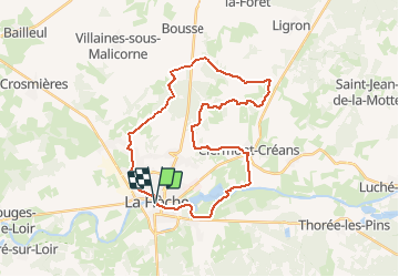
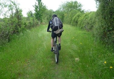
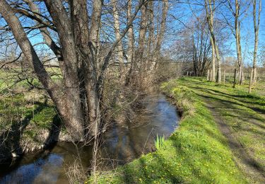
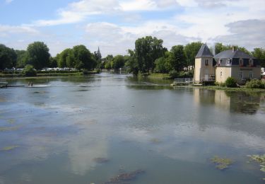
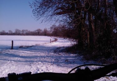
Tour Mountainbike von 31 km verfügbar auf Pays de la Loire, Sarthe, La Flèche. Diese Tour wird von tracegps vorgeschlagen.
Beschreibung
Petite boucle agréable au départ de la Flèche. Quelques beaux chemins creux. Retour par les bords de loir jusqu'au centre ville. Difficulté moyenne.
Ort
Land:
France
Region :
Pays de la Loire
Abteilung/Provinz :
Sarthe
Kommune :
La Flèche
Standort:
Unknown
Gehen Sie:(Dec)
Gehen Sie:(UTM)
719472 ; 5286724 (30T) N.
Kommentare
Touren in der Umgebung
![Tour Mountainbike La Flèche - La Flèche Sud - Photo](https://media.geolcdn.com/t/375/260/ext.jpg?maxdim=2&url=https%3A%2F%2Fstatic1.geolcdn.com%2Fsiteimages%2Fupload%2Ffiles%2F1524743154velo.jpg)
![Mountainbike Mountainbike](https://static1.geolcdn.com/sitytour/trail-icons/202.png)
La Flèche Sud
Mountainbike
Medium
(2)
La Flèche,
Pays de la Loire,
Sarthe,
France
![](/images/other/stat-length.png)
46 km | 51 km-effort
3h 15min
![](https://static1.geolcdn.com/siteimages/upload/files/16400158638029165_repeat_loop_refresh_sync_direction_icon.png)
Ja
![Tour Mountainbike La Flèche - La Flèche - Saumur par les chemins - Photo](https://media.geolcdn.com/t/375/260/ext.jpg?maxdim=2&url=https%3A%2F%2Fservices.sitytrail.com%2FGeolivesWS%2FDownloadMedia.ashx%3FTrailID%3D316964%26Media%3D16084_6.jpg)
![Mountainbike Mountainbike](https://static1.geolcdn.com/sitytour/trail-icons/202.png)
La Flèche - Saumur par les chemins
Mountainbike
Medium
La Flèche,
Pays de la Loire,
Sarthe,
France
![](/images/other/stat-length.png)
88 km | 99 km-effort
5h 0min
![](https://static1.geolcdn.com/siteimages/upload/files/16400158638029165_repeat_loop_refresh_sync_direction_icon.png)
Nein
![Tour Mountainbike La Flèche - La Flèche - Grande Boucle Sud Ouest - Photo](https://media.geolcdn.com/t/375/260/ext.jpg?maxdim=2&url=https%3A%2F%2Fservices.sitytrail.com%2FGeolivesWS%2FDownloadMedia.ashx%3FTrailID%3D215065%26Media%3D15639_6.jpg)
![Mountainbike Mountainbike](https://static1.geolcdn.com/sitytour/trail-icons/202.png)
La Flèche - Grande Boucle Sud Ouest
Mountainbike
Schwierig
La Flèche,
Pays de la Loire,
Sarthe,
France
![](/images/other/stat-length.png)
84 km | 96 km-effort
6h 0min
![](https://static1.geolcdn.com/siteimages/upload/files/16400158638029165_repeat_loop_refresh_sync_direction_icon.png)
Ja
![Tour Mountainbike La Flèche - Tour de la Flèche en 4 Jours - Photo](https://media.geolcdn.com/t/375/260/ext.jpg?maxdim=2&url=https%3A%2F%2Fservices.sitytrail.com%2FGeolivesWS%2FDownloadMedia.ashx%3FTrailID%3D172268%26Media%3D13580_3.jpg)
![Mountainbike Mountainbike](https://static1.geolcdn.com/sitytour/trail-icons/202.png)
Tour de la Flèche en 4 Jours
Mountainbike
Einfach
La Flèche,
Pays de la Loire,
Sarthe,
France
![](/images/other/stat-length.png)
163 km | 181 km-effort
16h 0min
![](https://static1.geolcdn.com/siteimages/upload/files/16400158638029165_repeat_loop_refresh_sync_direction_icon.png)
Ja
![Tour Radtourismus La Flèche - La Flèche, Luché pringé - Photo](https://media.geolcdn.com/t/375/260/ext.jpg?maxdim=2&url=https%3A%2F%2Fstatic1.geolcdn.com%2Fsiteimages%2Fupload%2Ffiles%2F1524743154velo.jpg)
![Radtourismus Radtourismus](https://static1.geolcdn.com/sitytour/trail-icons/204.png)
La Flèche, Luché pringé
Radtourismus
Einfach
La Flèche,
Pays de la Loire,
Sarthe,
France
![](/images/other/stat-length.png)
33 km | 35 km-effort
2h 15min
![](https://static1.geolcdn.com/siteimages/upload/files/16400158638029165_repeat_loop_refresh_sync_direction_icon.png)
Nein
![Tour Mountainbike La Flèche - Nico tout seul très beau temps - Photo](https://media.geolcdn.com/t/375/260/195ac492-309c-4a9f-bfb4-f1b1c36a915d.jpg&format=jpg&maxdim=2)
![Mountainbike Mountainbike](https://static1.geolcdn.com/sitytour/trail-icons/202.png)
Nico tout seul très beau temps
Mountainbike
La Flèche,
Pays de la Loire,
Sarthe,
France
![](/images/other/stat-length.png)
29 km | 32 km-effort
1h 35min
![](https://static1.geolcdn.com/siteimages/upload/files/16400158638029165_repeat_loop_refresh_sync_direction_icon.png)
Ja
![Tour Mountainbike La Flèche - La Flèche - Grande Boucle Nord Est - Photo](https://media.geolcdn.com/t/375/260/ext.jpg?maxdim=2&url=https%3A%2F%2Fservices.sitytrail.com%2FGeolivesWS%2FDownloadMedia.ashx%3FTrailID%3D215075%26Media%3D15651_2.jpg)
![Mountainbike Mountainbike](https://static1.geolcdn.com/sitytour/trail-icons/202.png)
La Flèche - Grande Boucle Nord Est
Mountainbike
Schwierig
La Flèche,
Pays de la Loire,
Sarthe,
France
![](/images/other/stat-length.png)
88 km | 101 km-effort
6h 0min
![](https://static1.geolcdn.com/siteimages/upload/files/16400158638029165_repeat_loop_refresh_sync_direction_icon.png)
Ja
![Tour Mountainbike La Flèche - La Flèche Nord Ouest - Photo](https://media.geolcdn.com/t/375/260/ext.jpg?maxdim=2&url=https%3A%2F%2Fservices.sitytrail.com%2FGeolivesWS%2FDownloadMedia.ashx%3FTrailID%3D118816%26Media%3D13025_1.jpg)
![Mountainbike Mountainbike](https://static1.geolcdn.com/sitytour/trail-icons/202.png)
La Flèche Nord Ouest
Mountainbike
Einfach
La Flèche,
Pays de la Loire,
Sarthe,
France
![](/images/other/stat-length.png)
35 km | 39 km-effort
2h 30min
![](https://static1.geolcdn.com/siteimages/upload/files/16400158638029165_repeat_loop_refresh_sync_direction_icon.png)
Ja
![Tour Mountainbike La Flèche - La Fleche - Nord Est - Photo](https://media.geolcdn.com/t/375/260/ext.jpg?maxdim=2&url=https%3A%2F%2Fservices.sitytrail.com%2FGeolivesWS%2FDownloadMedia.ashx%3FTrailID%3D118814%26Media%3D13022_1.jpg)
![Mountainbike Mountainbike](https://static1.geolcdn.com/sitytour/trail-icons/202.png)
La Fleche - Nord Est
Mountainbike
Medium
La Flèche,
Pays de la Loire,
Sarthe,
France
![](/images/other/stat-length.png)
42 km | 48 km-effort
3h 0min
![](https://static1.geolcdn.com/siteimages/upload/files/16400158638029165_repeat_loop_refresh_sync_direction_icon.png)
Ja