![](/images/other/stat-length.png)
![Tour Wandern Burdignes - Burdignes - Croix de Chirol - Photo](https://media.geolcdn.com/t/1900/400/ext.pjpeg?maxdim=2&url=https%3A%2F%2Fservices.sitytrail.com%2FGeolivesWS%2FDownloadMedia.ashx%3FTrailID%3D118738%26Media%3D12933_2.jpg)
Burdignes - Croix de Chirol
tracegps
Benutzer
![Länge](/images/other/stat-length.png)
Länge
9,7 km
![Maximale Höhe](https://static1.geolcdn.com/siteimages/upload/files/1508320355ic_sort_altitude_max_24dp.png)
Maximale Höhe
945 m
![Positive Höhendifferenz](https://static1.geolcdn.com/siteimages/upload/files/1508320355ic_sort_den_pos_24dp.png)
Positive Höhendifferenz
304 m
![Km-Effort](/images/other/stat-length.png)
Km-Effort
13,7 km
![Min. Höhe](https://static1.geolcdn.com/siteimages/upload/files/1508320355ic_sort_altitude_min_24dp.png)
Min. Höhe
725 m
![Negative Höhendifferenz](https://static1.geolcdn.com/siteimages/upload/files/1508320355ic_sort_den_neg_24dp.png)
Negative Höhendifferenz
303 m
![Boucle](https://static1.geolcdn.com/siteimages/upload/files/16400158638029165_repeat_loop_refresh_sync_direction_icon.png)
Boucle
Ja
Erstellungsdatum :
2014-12-10 00:00:00.0
Letzte Änderung :
2014-12-10 00:00:00.0
![Wandern](https://static1.geolcdn.com/sitytour/trail-icons/101.png)
2h30
Schwierigkeit : Medium
![Scannen Sie diesen QR-Code, um die Tour in der SityTrail-Anwendung zu öffnen](https://capi.geolives.com/qq0zvz2zws4bq2lad0pu/sitytour/trails/118738/qr.png?size=200)
Kostenlosegpshiking-Anwendung
Über SityTrail
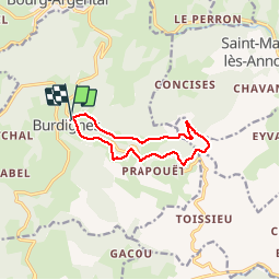
Tour Wandern von 9,7 km verfügbar auf Auvergne-Rhone-Alpen, Loire, Burdignes. Diese Tour wird von tracegps vorgeschlagen.
Beschreibung
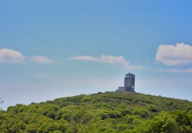
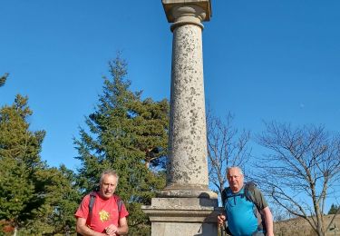
Belle promenade sur une crête ensoleillée à partir du "Bourg du feu"- Burdignes - Vue sur la vallée du Rhône et les Alpes.
Ort
Land:
France
Region :
Auvergne-Rhone-Alpen
Abteilung/Provinz :
Loire
Kommune :
Burdignes
Standort:
Unknown
Gehen Sie:(Dec)
Gehen Sie:(UTM)
622850 ; 5014159 (31T) N.
Kommentare
Touren in der Umgebung
![Tour Wandern Villevocance - 07 mer de glace Cx chirols - Photo](https://media.geolcdn.com/t/375/260/650c9d29-4730-4be0-bed1-27c07fa096d1.jpg&format=jpg&maxdim=2)
![Wandern Wandern](https://static1.geolcdn.com/sitytour/trail-icons/101.png)
07 mer de glace Cx chirols
Wandern
Medium
Villevocance,
Auvergne-Rhone-Alpen,
Ardèche,
France
![](/images/other/stat-length.png)
14,8 km | 23 km-effort
6h 5min
![](https://static1.geolcdn.com/siteimages/upload/files/16400158638029165_repeat_loop_refresh_sync_direction_icon.png)
Ja
![Tour Mountainbike Bourg-Argental - Pilat par la face sud - Photo](https://media.geolcdn.com/t/375/260/ext.jpg?maxdim=2&url=https%3A%2F%2Fstatic1.geolcdn.com%2Fsiteimages%2Fupload%2Ffiles%2F1524743154velo.jpg)
![Mountainbike Mountainbike](https://static1.geolcdn.com/sitytour/trail-icons/202.png)
Pilat par la face sud
Mountainbike
Schwierig
(1)
Bourg-Argental,
Auvergne-Rhone-Alpen,
Loire,
France
![](/images/other/stat-length.png)
34 km | 50 km-effort
4h 30min
![](https://static1.geolcdn.com/siteimages/upload/files/16400158638029165_repeat_loop_refresh_sync_direction_icon.png)
Ja
![Tour Wandern Villevocance - la Mer de glace - Photo](https://media.geolcdn.com/t/375/260/fa8631d6-f8e5-4999-b914-4f21f7ed2db5.jpg&format=jpg&maxdim=2)
![Wandern Wandern](https://static1.geolcdn.com/sitytour/trail-icons/101.png)
la Mer de glace
Wandern
Schwierig
Villevocance,
Auvergne-Rhone-Alpen,
Ardèche,
France
![](/images/other/stat-length.png)
11,9 km | 18,3 km-effort
6h 20min
![](https://static1.geolcdn.com/siteimages/upload/files/16400158638029165_repeat_loop_refresh_sync_direction_icon.png)
Ja
![Tour Zu Fuß Bourg-Argental - Pilat Nº2: Bourg-Argental - Le Grand Bois - Photo](https://media.geolcdn.com/t/375/260/60d1cf6a-3df8-427b-adf6-8bc73f4177cc.jpeg&format=jpg&maxdim=2)
![Zu Fuß Zu Fuß](https://static1.geolcdn.com/sitytour/trail-icons/100.png)
Pilat Nº2: Bourg-Argental - Le Grand Bois
Zu Fuß
Schwierig
Bourg-Argental,
Auvergne-Rhone-Alpen,
Loire,
France
![](/images/other/stat-length.png)
22 km | 33 km-effort
7h 30min
![](https://static1.geolcdn.com/siteimages/upload/files/16400158638029165_repeat_loop_refresh_sync_direction_icon.png)
Ja
![Tour Wandern Vanosc - Vanosc - Photo](https://media.geolcdn.com/t/375/260/ext.jpg?maxdim=2&url=https%3A%2F%2Fservices.sitytrail.com%2FGeolivesWS%2FDownloadMedia.ashx%3FTrailID%3D614656%26Media%3D20160802113727.jpg)
![Wandern Wandern](https://static1.geolcdn.com/sitytour/trail-icons/101.png)
Vanosc
Wandern
Einfach
Vanosc,
Auvergne-Rhone-Alpen,
Ardèche,
France
![](/images/other/stat-length.png)
17,3 km | 27 km-effort
5h 46min
![](https://static1.geolcdn.com/siteimages/upload/files/16400158638029165_repeat_loop_refresh_sync_direction_icon.png)
Ja
![Tour Wandern Bourg-Argental - Bourg Argental 2013 - Photo](https://media.geolcdn.com/t/375/260/ext.jpg?maxdim=2&url=https%3A%2F%2Fservices.sitytrail.com%2FGeolivesWS%2FDownloadMedia.ashx%3FTrailID%3D317082%26Media%3D16228_5.jpg)
![Wandern Wandern](https://static1.geolcdn.com/sitytour/trail-icons/101.png)
Bourg Argental 2013
Wandern
Medium
Bourg-Argental,
Auvergne-Rhone-Alpen,
Loire,
France
![](/images/other/stat-length.png)
22 km | 34 km-effort
6h 30min
![](https://static1.geolcdn.com/siteimages/upload/files/16400158638029165_repeat_loop_refresh_sync_direction_icon.png)
Ja
![Tour Wandern Saint-Sauveur-en-Rue - La Taillairdine 2013 - St Sauveur en Rue - Photo](https://media.geolcdn.com/t/375/260/ext.jpg?maxdim=2&url=https%3A%2F%2Fservices.sitytrail.com%2FGeolivesWS%2FDownloadMedia.ashx%3FTrailID%3D316971%26Media%3D16093_3.jpg)
![Wandern Wandern](https://static1.geolcdn.com/sitytour/trail-icons/101.png)
La Taillairdine 2013 - St Sauveur en Rue
Wandern
Medium
Saint-Sauveur-en-Rue,
Auvergne-Rhone-Alpen,
Loire,
France
![](/images/other/stat-length.png)
25 km | 39 km-effort
7h 0min
![](https://static1.geolcdn.com/siteimages/upload/files/16400158638029165_repeat_loop_refresh_sync_direction_icon.png)
Ja
![Tour Wandern Villevocance - croix de chirol - Photo](https://media.geolcdn.com/t/375/260/c128a409-2694-440b-a521-434765b7b550.jpg&format=jpg&maxdim=2)
![Wandern Wandern](https://static1.geolcdn.com/sitytour/trail-icons/101.png)
croix de chirol
Wandern
Sehr schwierig
Villevocance,
Auvergne-Rhone-Alpen,
Ardèche,
France
![](/images/other/stat-length.png)
17,7 km | 27 km-effort
7h 4min
![](https://static1.geolcdn.com/siteimages/upload/files/16400158638029165_repeat_loop_refresh_sync_direction_icon.png)
Ja
![Tour Wandern Villevocance - 07 cc chirol 2020 - Photo](https://media.geolcdn.com/t/375/260/ext.jpg?maxdim=2&url=https%3A%2F%2Fstatic1.geolcdn.com%2Fsiteimages%2Fupload%2Ffiles%2F1553511878bg_sport_marche.png)
![Wandern Wandern](https://static1.geolcdn.com/sitytour/trail-icons/101.png)
07 cc chirol 2020
Wandern
Medium
Villevocance,
Auvergne-Rhone-Alpen,
Ardèche,
France
![](/images/other/stat-length.png)
15,5 km | 24 km-effort
4h 12min
![](https://static1.geolcdn.com/siteimages/upload/files/16400158638029165_repeat_loop_refresh_sync_direction_icon.png)
Nein
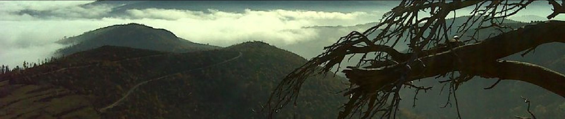
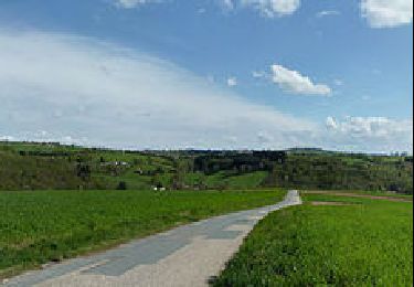
Très belle balade en balcon, vue sur le Vercors, les Alpes. Pas de difficultés particulières pour un marcheur.