![](/images/other/stat-length.png)
![Tour Wandern Vimoutiers - Marche de la libération Vimoutiers - Photo](https://media.geolcdn.com/t/1900/400/ext.pjpeg?maxdim=2&url=https%3A%2F%2Fstatic1.geolcdn.com%2Fsiteimages%2Fupload%2Ffiles%2F1553511878bg_sport_marche.png)
Marche de la libération Vimoutiers
guy.presier
Benutzer
![Länge](/images/other/stat-length.png)
Länge
11 km
![Maximale Höhe](https://static1.geolcdn.com/siteimages/upload/files/1508320355ic_sort_altitude_max_24dp.png)
Maximale Höhe
226 m
![Positive Höhendifferenz](https://static1.geolcdn.com/siteimages/upload/files/1508320355ic_sort_den_pos_24dp.png)
Positive Höhendifferenz
149 m
![Km-Effort](/images/other/stat-length.png)
Km-Effort
13 km
![Min. Höhe](https://static1.geolcdn.com/siteimages/upload/files/1508320355ic_sort_altitude_min_24dp.png)
Min. Höhe
144 m
![Negative Höhendifferenz](https://static1.geolcdn.com/siteimages/upload/files/1508320355ic_sort_den_neg_24dp.png)
Negative Höhendifferenz
150 m
![Boucle](https://static1.geolcdn.com/siteimages/upload/files/16400158638029165_repeat_loop_refresh_sync_direction_icon.png)
Boucle
Ja
Erstellungsdatum :
2019-05-07 02:32:19.179
Letzte Änderung :
2019-05-07 02:32:19.179
![Wandern](https://static1.geolcdn.com/sitytour/trail-icons/101.png)
2h38
Schwierigkeit : Medium
![Scannen Sie diesen QR-Code, um die Tour in der SityTrail-Anwendung zu öffnen](https://capi.geolives.com/qq0zvz2zws4bq2lad0pu/sitytour/trails/1143616/qr.png?size=200)
Kostenlosegpshiking-Anwendung
Über SityTrail
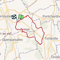
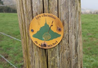
Tour Wandern von 11 km verfügbar auf Normandie, Orne, Vimoutiers. Diese Tour wird von guy.presier vorgeschlagen.
Beschreibung
Balade de 11Km en passant par le château de Vimer transformé en hôpital après les bombardement de Vimoutiers le 14 juin 1944.
Retour par le château du Mézeray.
Ort
Land:
France
Region :
Normandie
Abteilung/Provinz :
Orne
Kommune :
Vimoutiers
Standort:
Unknown
Gehen Sie:(Dec)
Gehen Sie:(UTM)
295982 ; 5422727 (31U) N.
Kommentare
Touren in der Umgebung
![Tour Mountainbike Vimoutiers - Espace VTT FFC du Pays d'Auge Ornais- Circuit n°15 - Plateau du Sap - Photo](https://media.geolcdn.com/t/375/260/ext.jpg?maxdim=2&url=https%3A%2F%2Fservices.sitytrail.com%2FGeolivesWS%2FDownloadMedia.ashx%3FTrailID%3D102043%26Media%3D2364_2.jpg)
![Mountainbike Mountainbike](https://static1.geolcdn.com/sitytour/trail-icons/202.png)
Espace VTT FFC du Pays d'Auge Ornais- Circuit n°15 - Plateau du Sap
Mountainbike
Schwierig
(2)
Vimoutiers,
Normandie,
Orne,
France
![](/images/other/stat-length.png)
40 km | 47 km-effort
3h 15min
![](https://static1.geolcdn.com/siteimages/upload/files/16400158638029165_repeat_loop_refresh_sync_direction_icon.png)
Ja
![Tour Wandern Lisores - Lisores - Photo](https://media.geolcdn.com/t/375/260/fb89d089-a4c5-4080-be7d-7565f57f6a48.jpg&format=jpg&maxdim=2)
![Wandern Wandern](https://static1.geolcdn.com/sitytour/trail-icons/101.png)
![Tour 4x4 Lisores - Sortie land61 1/3/20 - Photo](https://media.geolcdn.com/t/375/260/c2c1dcc0-d716-4b78-8e62-a2996a29eb43.jpg&format=jpg&maxdim=2)
![4x4 4x4](https://static1.geolcdn.com/sitytour/trail-icons/403.png)
Sortie land61 1/3/20
4x4
Sehr schwierig
Lisores,
Normandie,
Calvados,
France
![](/images/other/stat-length.png)
38 km | 46 km-effort
3h 32min
![](https://static1.geolcdn.com/siteimages/upload/files/16400158638029165_repeat_loop_refresh_sync_direction_icon.png)
Nein
![Tour Wandern Vimoutiers - Au pays de Marie Harel - Vimoutiers - Photo](https://media.geolcdn.com/t/375/260/ext.jpg?maxdim=2&url=https%3A%2F%2Fservices.sitytrail.com%2FGeolivesWS%2FDownloadMedia.ashx%3FTrailID%3D317650%26Media%3D16926_6.jpg)
![Wandern Wandern](https://static1.geolcdn.com/sitytour/trail-icons/101.png)
Au pays de Marie Harel - Vimoutiers
Wandern
Schwierig
Vimoutiers,
Normandie,
Orne,
France
![](/images/other/stat-length.png)
20 km | 24 km-effort
5h 0min
![](https://static1.geolcdn.com/siteimages/upload/files/16400158638029165_repeat_loop_refresh_sync_direction_icon.png)
Ja
![Tour Wandern Vimoutiers - Au pays du Camembert - Vimoutiers - Photo](https://media.geolcdn.com/t/375/260/ext.jpg?maxdim=2&url=https%3A%2F%2Fservices.sitytrail.com%2FGeolivesWS%2FDownloadMedia.ashx%3FTrailID%3D111659%26Media%3D7897_3.jpg)
![Wandern Wandern](https://static1.geolcdn.com/sitytour/trail-icons/101.png)
Au pays du Camembert - Vimoutiers
Wandern
Schwierig
Vimoutiers,
Normandie,
Orne,
France
![](/images/other/stat-length.png)
18 km | 24 km-effort
5h 0min
![](https://static1.geolcdn.com/siteimages/upload/files/16400158638029165_repeat_loop_refresh_sync_direction_icon.png)
Ja
![Tour Wandern Vimoutiers - Vimoutier - Photo](https://media.geolcdn.com/t/375/260/a7564173-ba23-46de-9387-05203aa51f87.jpg&format=jpg&maxdim=2)
![Wandern Wandern](https://static1.geolcdn.com/sitytour/trail-icons/101.png)
![Tour Wandern Canapville - camapville 61 - Photo](https://media.geolcdn.com/t/375/260/02c54343-4376-445b-8cd3-5ab243f48f72.jpg&format=jpg&maxdim=2)
![Wandern Wandern](https://static1.geolcdn.com/sitytour/trail-icons/101.png)
camapville 61
Wandern
Sehr leicht
Canapville,
Normandie,
Orne,
France
![](/images/other/stat-length.png)
13,1 km | 15,3 km-effort
2h 40min
![](https://static1.geolcdn.com/siteimages/upload/files/16400158638029165_repeat_loop_refresh_sync_direction_icon.png)
Ja
![Tour Wandern Vimoutiers - Vimoutiers 11102020 - Photo](https://media.geolcdn.com/t/375/260/b9f69f9c-7406-46c7-83b8-8941596ba983.jpg&format=jpg&maxdim=2)
![Wandern Wandern](https://static1.geolcdn.com/sitytour/trail-icons/101.png)
Vimoutiers 11102020
Wandern
Medium
Vimoutiers,
Normandie,
Orne,
France
![](/images/other/stat-length.png)
18,3 km | 25 km-effort
3h 50min
![](https://static1.geolcdn.com/siteimages/upload/files/16400158638029165_repeat_loop_refresh_sync_direction_icon.png)
Ja
![Tour Wandern Val-de-Vie - Ste Foy de Montgommery - Photo](https://media.geolcdn.com/t/375/260/cf94b937-e308-4b54-9dcd-889c5442372a.jpg&format=jpg&maxdim=2)
![Wandern Wandern](https://static1.geolcdn.com/sitytour/trail-icons/101.png)
Ste Foy de Montgommery
Wandern
Medium
Val-de-Vie,
Normandie,
Calvados,
France
![](/images/other/stat-length.png)
17,4 km | 21 km-effort
3h 31min
![](https://static1.geolcdn.com/siteimages/upload/files/16400158638029165_repeat_loop_refresh_sync_direction_icon.png)
Ja