![](/images/other/stat-length.png)
![Tour Wandern Cornus - Sorgues - Photo](https://media.geolcdn.com/t/1900/400/ext.pjpeg?maxdim=2&url=https%3A%2F%2Fstatic1.geolcdn.com%2Fsiteimages%2Fupload%2Ffiles%2F1553511878bg_sport_marche.png)
Sorgues
Groupe de marche du Recantou
La marche dans les monts d'Orb, le Caroux, et dans l'Hérault et l'aveyron
![Länge](/images/other/stat-length.png)
Länge
13,4 km
![Maximale Höhe](https://static1.geolcdn.com/siteimages/upload/files/1508320355ic_sort_altitude_max_24dp.png)
Maximale Höhe
836 m
![Positive Höhendifferenz](https://static1.geolcdn.com/siteimages/upload/files/1508320355ic_sort_den_pos_24dp.png)
Positive Höhendifferenz
417 m
![Km-Effort](/images/other/stat-length.png)
Km-Effort
19 km
![Min. Höhe](https://static1.geolcdn.com/siteimages/upload/files/1508320355ic_sort_altitude_min_24dp.png)
Min. Höhe
558 m
![Negative Höhendifferenz](https://static1.geolcdn.com/siteimages/upload/files/1508320355ic_sort_den_neg_24dp.png)
Negative Höhendifferenz
417 m
![Boucle](https://static1.geolcdn.com/siteimages/upload/files/16400158638029165_repeat_loop_refresh_sync_direction_icon.png)
Boucle
Ja
Erstellungsdatum :
2019-05-07 02:27:48.173
Letzte Änderung :
2019-05-07 02:27:48.173
![Wandern](https://static1.geolcdn.com/sitytour/trail-icons/101.png)
3h59
Schwierigkeit : Schwierig
![Scannen Sie diesen QR-Code, um die Tour in der SityTrail-Anwendung zu öffnen](https://capi.geolives.com/qq0zvz2zws4bq2lad0pu/sitytour/trails/1143189/qr.png?size=200)
Kostenlosegpshiking-Anwendung
Über SityTrail
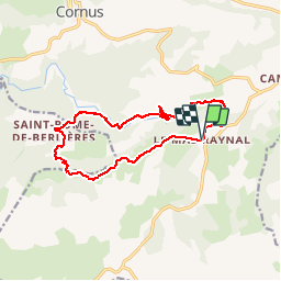
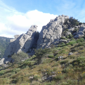
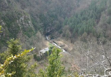
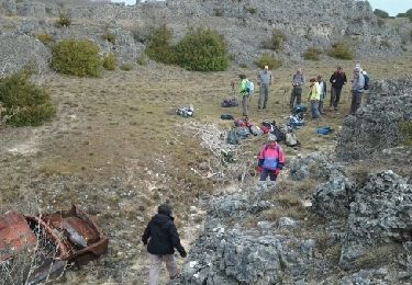
Tour Wandern von 13,4 km verfügbar auf Okzitanien, Aveyron, Cornus. Diese Tour wird von Groupe de marche du Recantou vorgeschlagen.
Beschreibung
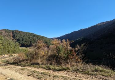
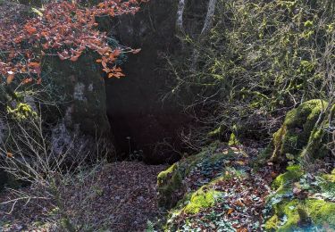
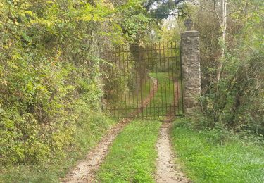
Résurgence de la Sorgues depuis le mas Raynal et st Rome de Berlière
Ort
Land:
France
Region :
Okzitanien
Abteilung/Provinz :
Aveyron
Kommune :
Cornus
Standort:
Unknown
Gehen Sie:(Dec)
Gehen Sie:(UTM)
517467 ; 4857703 (31T) N.
Kommentare
Touren in der Umgebung
![Tour Wandern Cornus - guilhaumard n 1 col de licous au col de licous - Photo](https://media.geolcdn.com/t/375/260/ext.jpg?maxdim=2&url=https%3A%2F%2Fstatic1.geolcdn.com%2Fsiteimages%2Fupload%2Ffiles%2F1553511878bg_sport_marche.png)
![Wandern Wandern](https://static1.geolcdn.com/sitytour/trail-icons/101.png)
guilhaumard n 1 col de licous au col de licous
Wandern
Einfach
(2)
Cornus,
Okzitanien,
Aveyron,
France
![](/images/other/stat-length.png)
14 km | 16,6 km-effort
3h 44min
![](https://static1.geolcdn.com/siteimages/upload/files/16400158638029165_repeat_loop_refresh_sync_direction_icon.png)
Ja
![Tour Zu Fuß Les Rives - Randonnée du 07/06/2022 à 09:14 - Photo](https://media.geolcdn.com/t/375/260/16545ddc-2e01-4c57-bc66-aedbefc75782.jpg&format=jpg&maxdim=2)
![Zu Fuß Zu Fuß](https://static1.geolcdn.com/sitytour/trail-icons/100.png)
Randonnée du 07/06/2022 à 09:14
Zu Fuß
Einfach
Les Rives,
Okzitanien,
Hérault,
France
![](/images/other/stat-length.png)
14,3 km | 17,1 km-effort
3h 53min
![](https://static1.geolcdn.com/siteimages/upload/files/16400158638029165_repeat_loop_refresh_sync_direction_icon.png)
Ja
![Tour Wandern La Couvertoirade - 12348835-La salvetat aven de la peur - Photo](https://media.geolcdn.com/t/375/260/ext.jpg?maxdim=2&url=https%3A%2F%2Fstatic1.geolcdn.com%2Fsiteimages%2Fupload%2Ffiles%2F1553511878bg_sport_marche.png)
![Wandern Wandern](https://static1.geolcdn.com/sitytour/trail-icons/101.png)
12348835-La salvetat aven de la peur
Wandern
Sehr schwierig
(1)
La Couvertoirade,
Okzitanien,
Aveyron,
France
![](/images/other/stat-length.png)
18,7 km | 22 km-effort
5h 6min
![](https://static1.geolcdn.com/siteimages/upload/files/16400158638029165_repeat_loop_refresh_sync_direction_icon.png)
Nein
![Tour Wandern Cornus - mas raynal - Photo](https://media.geolcdn.com/t/375/260/ext.jpg?maxdim=2&url=https%3A%2F%2Fservices.sitytrail.com%2FGeolivesWS%2FDownloadMedia.ashx%3FTrailID%3D1082580%26Media%3Dfix__20140320141005.jpg)
![Wandern Wandern](https://static1.geolcdn.com/sitytour/trail-icons/101.png)
![Tour Wandern Cornus - mas raynal - Photo](https://media.geolcdn.com/t/375/260/ext.jpg?maxdim=2&url=https%3A%2F%2Fservices.sitytrail.com%2FGeolivesWS%2FDownloadMedia.ashx%3FTrailID%3D258902%26Media%3Dfix__20140320101319.jpg)
![Wandern Wandern](https://static1.geolcdn.com/sitytour/trail-icons/101.png)
![Tour Wandern Cornus - Les Mas Raynal Bois de Véran - Photo](https://media.geolcdn.com/t/375/260/2353198e-f687-4735-9b48-5c8daa55d625.jpg&format=jpg&maxdim=2)
![Wandern Wandern](https://static1.geolcdn.com/sitytour/trail-icons/101.png)
Les Mas Raynal Bois de Véran
Wandern
Medium
Cornus,
Okzitanien,
Aveyron,
France
![](/images/other/stat-length.png)
19,3 km | 0 m-effort
6h 0min
![](https://static1.geolcdn.com/siteimages/upload/files/16400158638029165_repeat_loop_refresh_sync_direction_icon.png)
Ja
![Tour Wandern Cornus - Plateau de Guilhaumard Résurgence de la Sorgues - Photo](https://media.geolcdn.com/t/375/260/d161ac8e-7672-40a2-8544-3941a3fb8bfc.jpg&format=jpg&maxdim=2)
![Wandern Wandern](https://static1.geolcdn.com/sitytour/trail-icons/101.png)
Plateau de Guilhaumard Résurgence de la Sorgues
Wandern
Medium
Cornus,
Okzitanien,
Aveyron,
France
![](/images/other/stat-length.png)
18,5 km | 26 km-effort
6h 0min
![](https://static1.geolcdn.com/siteimages/upload/files/16400158638029165_repeat_loop_refresh_sync_direction_icon.png)
Ja
![Tour Wandern Cornus - Plateau de Guilhaumard La Sorgues - Photo](https://media.geolcdn.com/t/375/260/680bff7b-5820-4b4d-ab5a-ee9196d735b3.jpg&format=jpg&maxdim=2)
![Wandern Wandern](https://static1.geolcdn.com/sitytour/trail-icons/101.png)
Plateau de Guilhaumard La Sorgues
Wandern
Medium
Cornus,
Okzitanien,
Aveyron,
France
![](/images/other/stat-length.png)
16,8 km | 23 km-effort
5h 0min
![](https://static1.geolcdn.com/siteimages/upload/files/16400158638029165_repeat_loop_refresh_sync_direction_icon.png)
Ja
![Tour Wandern Cornus - cornus et Sorgues in live - Photo](https://media.geolcdn.com/t/375/260/9c3ee960-b821-4ea1-9055-36f6b7f2d87e.jpg&format=jpg&maxdim=2)
![Wandern Wandern](https://static1.geolcdn.com/sitytour/trail-icons/101.png)
cornus et Sorgues in live
Wandern
Schwierig
Cornus,
Okzitanien,
Aveyron,
France
![](/images/other/stat-length.png)
23 km | 32 km-effort
5h 32min
![](https://static1.geolcdn.com/siteimages/upload/files/16400158638029165_repeat_loop_refresh_sync_direction_icon.png)
Ja
343