![](/images/other/stat-length.png)
![Tour Wandern Villars - Villars abbaye de Boschaud - Photo](https://media.geolcdn.com/t/1900/400/ext.pjpeg?maxdim=2&url=https%3A%2F%2Fservices.sitytrail.com%2FGeolivesWS%2FDownloadMedia.ashx%3FTrailID%3D1128638%26Media%3Dfix__20190330112715.jpg)
Villars abbaye de Boschaud
rougilabuse
Benutzer
![Länge](/images/other/stat-length.png)
Länge
12,4 km
![Maximale Höhe](https://static1.geolcdn.com/siteimages/upload/files/1508320355ic_sort_altitude_max_24dp.png)
Maximale Höhe
209 m
![Positive Höhendifferenz](https://static1.geolcdn.com/siteimages/upload/files/1508320355ic_sort_den_pos_24dp.png)
Positive Höhendifferenz
259 m
![Km-Effort](/images/other/stat-length.png)
Km-Effort
15,8 km
![Min. Höhe](https://static1.geolcdn.com/siteimages/upload/files/1508320355ic_sort_altitude_min_24dp.png)
Min. Höhe
136 m
![Negative Höhendifferenz](https://static1.geolcdn.com/siteimages/upload/files/1508320355ic_sort_den_neg_24dp.png)
Negative Höhendifferenz
255 m
![Boucle](https://static1.geolcdn.com/siteimages/upload/files/16400158638029165_repeat_loop_refresh_sync_direction_icon.png)
Boucle
Ja
Erstellungsdatum :
2019-03-30 16:30:19.034
Letzte Änderung :
2019-03-30 18:21:38.001
![Wandern](https://static1.geolcdn.com/sitytour/trail-icons/101.png)
3h58
Schwierigkeit : Medium
![Scannen Sie diesen QR-Code, um die Tour in der SityTrail-Anwendung zu öffnen](https://capi.geolives.com/qq0zvz2zws4bq2lad0pu/sitytour/trails/1128638/qr.png?size=200)
Kostenlosegpshiking-Anwendung
Über SityTrail
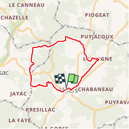
Tour Wandern von 12,4 km verfügbar auf Neu-Aquitanien, Dordogne, Villars. Diese Tour wird von rougilabuse vorgeschlagen.
Beschreibung
Départ sur le parking de la mairie de Villars le chemin est en partie balisé jaune. une petit partie ne l'est pas ou du moins mal indiquée. ne l'absence de balise bien suivre le tracé gps. une portion qui peux faire douter est indiqué sur le parcours.
Ort
Land:
France
Region :
Neu-Aquitanien
Abteilung/Provinz :
Dordogne
Kommune :
Villars
Standort:
Unknown
Gehen Sie:(Dec)
Gehen Sie:(UTM)
324170 ; 5032110 (31T) N.
Kommentare
Touren in der Umgebung
![Tour Wandern Villars - Puyguilhem - Grotte de Villars - Photo](https://media.geolcdn.com/t/375/260/ext.jpg?maxdim=2&url=https%3A%2F%2Fstatic1.geolcdn.com%2Fsiteimages%2Fupload%2Ffiles%2F1553511878bg_sport_marche.png)
![Wandern Wandern](https://static1.geolcdn.com/sitytour/trail-icons/101.png)
Puyguilhem - Grotte de Villars
Wandern
Schwierig
(1)
Villars,
Neu-Aquitanien,
Dordogne,
France
![](/images/other/stat-length.png)
13,6 km | 17,1 km-effort
3h 44min
![](https://static1.geolcdn.com/siteimages/upload/files/16400158638029165_repeat_loop_refresh_sync_direction_icon.png)
Ja
![Tour Wandern Villars - Villars Quinsac - Photo](https://media.geolcdn.com/t/375/260/ext.jpg?maxdim=2&url=https%3A%2F%2Fstatic1.geolcdn.com%2Fsiteimages%2Fupload%2Ffiles%2F1553511878bg_sport_marche.png)
![Wandern Wandern](https://static1.geolcdn.com/sitytour/trail-icons/101.png)
Villars Quinsac
Wandern
Einfach
(1)
Villars,
Neu-Aquitanien,
Dordogne,
France
![](/images/other/stat-length.png)
13 km | 16,3 km-effort
3h 30min
![](https://static1.geolcdn.com/siteimages/upload/files/16400158638029165_repeat_loop_refresh_sync_direction_icon.png)
Ja
![Tour Elektrofahrrad Villars - Villars -Nontron 10/09/22 - Photo](https://media.geolcdn.com/t/375/260/dc6c6183-5753-4c77-93b9-8d8265e9656d.jpg&format=jpg&maxdim=2)
![Elektrofahrrad Elektrofahrrad](https://static1.geolcdn.com/sitytour/trail-icons/205.png)
Villars -Nontron 10/09/22
Elektrofahrrad
Einfach
Villars,
Neu-Aquitanien,
Dordogne,
France
![](/images/other/stat-length.png)
34 km | 41 km-effort
2h 40min
![](https://static1.geolcdn.com/siteimages/upload/files/16400158638029165_repeat_loop_refresh_sync_direction_icon.png)
Nein
![Tour Wandern Villars - randogps24-488 - Photo](https://media.geolcdn.com/t/375/260/ext.jpg?maxdim=2&url=https%3A%2F%2Fstatic1.geolcdn.com%2Fsiteimages%2Fupload%2Ffiles%2F1553511878bg_sport_marche.png)
![Wandern Wandern](https://static1.geolcdn.com/sitytour/trail-icons/101.png)
randogps24-488
Wandern
Schwierig
Villars,
Neu-Aquitanien,
Dordogne,
France
![](/images/other/stat-length.png)
12,3 km | 15,7 km-effort
3h 34min
![](https://static1.geolcdn.com/siteimages/upload/files/16400158638029165_repeat_loop_refresh_sync_direction_icon.png)
Ja
![Tour Wandern Champagnac-de-Belair - Boucle de Champagnac de bel air - Photo](https://media.geolcdn.com/t/375/260/ext.jpg?maxdim=2&url=https%3A%2F%2Fstatic1.geolcdn.com%2Fsiteimages%2Fupload%2Ffiles%2F1553511878bg_sport_marche.png)
![Wandern Wandern](https://static1.geolcdn.com/sitytour/trail-icons/101.png)
Boucle de Champagnac de bel air
Wandern
Schwierig
Champagnac-de-Belair,
Neu-Aquitanien,
Dordogne,
France
![](/images/other/stat-length.png)
12,7 km | 15,7 km-effort
3h 33min
![](https://static1.geolcdn.com/siteimages/upload/files/16400158638029165_repeat_loop_refresh_sync_direction_icon.png)
Ja
![Tour Mountainbike Villars - Mareuil Pauliac Brantôme Pressillac - Photo](https://media.geolcdn.com/t/375/260/ext.jpg?maxdim=2&url=https%3A%2F%2Fstatic1.geolcdn.com%2Fsiteimages%2Fupload%2Ffiles%2F1524743154velo.jpg)
![Mountainbike Mountainbike](https://static1.geolcdn.com/sitytour/trail-icons/202.png)
Mareuil Pauliac Brantôme Pressillac
Mountainbike
Medium
Villars,
Neu-Aquitanien,
Dordogne,
France
![](/images/other/stat-length.png)
109 km | 136 km-effort
8h 23min
![](https://static1.geolcdn.com/siteimages/upload/files/16400158638029165_repeat_loop_refresh_sync_direction_icon.png)
Ja
![Tour Wandern Saint-Pierre-de-Côle - St Pierre de Côle Bruzac courte 12km - Photo](https://media.geolcdn.com/t/375/260/ext.jpg?maxdim=2&url=https%3A%2F%2Fstatic1.geolcdn.com%2Fsiteimages%2Fupload%2Ffiles%2F1553511878bg_sport_marche.png)
![Wandern Wandern](https://static1.geolcdn.com/sitytour/trail-icons/101.png)
St Pierre de Côle Bruzac courte 12km
Wandern
Einfach
Saint-Pierre-de-Côle,
Neu-Aquitanien,
Dordogne,
France
![](/images/other/stat-length.png)
11,5 km | 14,5 km-effort
3h 10min
![](https://static1.geolcdn.com/siteimages/upload/files/16400158638029165_repeat_loop_refresh_sync_direction_icon.png)
Ja
![Tour Wandern Condat-sur-Trincou - Condat-sur-Trincou Dronne Trincou 13km - Photo](https://media.geolcdn.com/t/375/260/ext.jpg?maxdim=2&url=https%3A%2F%2Fstatic1.geolcdn.com%2Fsiteimages%2Fupload%2Ffiles%2F1553511878bg_sport_marche.png)
![Wandern Wandern](https://static1.geolcdn.com/sitytour/trail-icons/101.png)
Condat-sur-Trincou Dronne Trincou 13km
Wandern
Einfach
Condat-sur-Trincou,
Neu-Aquitanien,
Dordogne,
France
![](/images/other/stat-length.png)
12,6 km | 15,8 km-effort
3h 26min
![](https://static1.geolcdn.com/siteimages/upload/files/16400158638029165_repeat_loop_refresh_sync_direction_icon.png)
Ja
![Tour Wandern Champagnac-de-Belair - Champagnac Belair Drone Trincou - Photo](https://media.geolcdn.com/t/375/260/ext.jpg?maxdim=2&url=https%3A%2F%2Fstatic1.geolcdn.com%2Fsiteimages%2Fupload%2Ffiles%2F1553511878bg_sport_marche.png)
![Wandern Wandern](https://static1.geolcdn.com/sitytour/trail-icons/101.png)
Champagnac Belair Drone Trincou
Wandern
Einfach
Champagnac-de-Belair,
Neu-Aquitanien,
Dordogne,
France
![](/images/other/stat-length.png)
13,4 km | 16,7 km-effort
3h 36min
![](https://static1.geolcdn.com/siteimages/upload/files/16400158638029165_repeat_loop_refresh_sync_direction_icon.png)
Ja