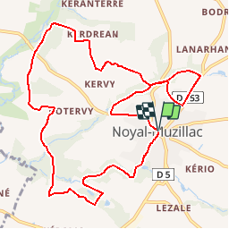
![](/images/other/stat-length.png)
![Tour Wandern Noyal-Muzillac - Le circuit de Trémondet - Noyal-Muzillac - Photo](https://media.geolcdn.com/t/1900/400/ext.pjpeg?maxdim=2&url=https%3A%2F%2Fservices.sitytrail.com%2FGeolivesWS%2FDownloadMedia.ashx%3FTrailID%3D112825%26Media%3D12546_6.jpg)
Le circuit de Trémondet - Noyal-Muzillac
tracegps
Benutzer
![Länge](/images/other/stat-length.png)
![Maximale Höhe](https://static1.geolcdn.com/siteimages/upload/files/1508320355ic_sort_altitude_max_24dp.png)
![Positive Höhendifferenz](https://static1.geolcdn.com/siteimages/upload/files/1508320355ic_sort_den_pos_24dp.png)
![Km-Effort](/images/other/stat-length.png)
![Min. Höhe](https://static1.geolcdn.com/siteimages/upload/files/1508320355ic_sort_altitude_min_24dp.png)
![Negative Höhendifferenz](https://static1.geolcdn.com/siteimages/upload/files/1508320355ic_sort_den_neg_24dp.png)
![Boucle](https://static1.geolcdn.com/siteimages/upload/files/16400158638029165_repeat_loop_refresh_sync_direction_icon.png)
![Wandern](https://static1.geolcdn.com/sitytour/trail-icons/101.png)
3h00
Schwierigkeit : Medium
![Scannen Sie diesen QR-Code, um die Tour in der SityTrail-Anwendung zu öffnen](https://capi.geolives.com/qq0zvz2zws4bq2lad0pu/sitytour/trails/112825/qr.png?size=200)
Kostenlosegpshiking-Anwendung
Über SityTrail
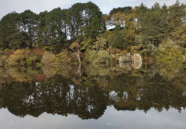
Tour Wandern von 11,7 km verfügbar auf Bretagne, Morbihan, Noyal-Muzillac. Diese Tour wird von tracegps vorgeschlagen.
Beschreibung
Une trentaine de communes portent le label "Communes du Patrimoine Rural de Bretagne" et mettent en commun leur volonté de sauvegarde, de mise en valeur et d'animation de leur patrimoine architectural et paysager. Des circuits de randonnées pour les uns, des balades champêtres pour les autres vous feront découvrir les bourgs et les villages de caractère de nos communes. L'office de tourisme du Pays de Muzillac, engagé dans une Démarche Qualité régionale, se fait un plaisir de renseigner et conseiller au mieux les estivants et de répondre à toutes demandes. De nombreuses animations et services vous y sont proposés, n’hésitez pas à en profiter ! NOYAL-MUZILLAC, commune de 2 500 âmes, au patrimoine architectural et historique remarquable, possède de nombreuses résidences du XVIème et XVIIème siècle aux lucarnes renaissances exceptionnelles. Sa campagne luxuriante entre vallons et rivières très poissonneuses, vous fera découvrir à travers ses sentiers, des sites naturels et des édifices au passé prestigieux. Départ de la place de la mairie, prés de l'église. Retrouvez la fiche du circuit sur le site des Communes du Patrimoine Rural de Bretagne. Suite au remembrement, le circuit a changé par endroit par rapport au plan.
Ort
Kommentare
Touren in der Umgebung
![Tour Wandern Le Guerno - PR_56_Le-Guerno_AA_01_Circuit1b_Des-Hospitaliers_20231001 - Photo](https://media.geolcdn.com/t/375/260/15aa618d-98ae-4b78-9bac-ca3a957c6041.jpg&format=jpg&maxdim=2)
![Wandern Wandern](https://static1.geolcdn.com/sitytour/trail-icons/101.png)
Wandern
![](/images/other/stat-length.png)
![](https://static1.geolcdn.com/siteimages/upload/files/16400158638029165_repeat_loop_refresh_sync_direction_icon.png)
![Tour Wandern Muzillac - Muzillac: Circuit des Chouans (officiel) - Photo](https://media.geolcdn.com/t/375/260/88c9148a-da9f-4073-b11e-3c0770243448.jpg&format=jpg&maxdim=2)
![Wandern Wandern](https://static1.geolcdn.com/sitytour/trail-icons/101.png)
Wandern
![](/images/other/stat-length.png)
![](https://static1.geolcdn.com/siteimages/upload/files/16400158638029165_repeat_loop_refresh_sync_direction_icon.png)
![Tour Wandern Muzillac - Rc-56_Muzillac-01_Bourg-Paul_Moulin-Pen_Mur_20200126 - Photo](https://media.geolcdn.com/t/375/260/6b6164e7-065f-479a-b1dc-3d810885f3a2.jpg&format=jpg&maxdim=2)
![Wandern Wandern](https://static1.geolcdn.com/sitytour/trail-icons/101.png)
Wandern
![](/images/other/stat-length.png)
![](https://static1.geolcdn.com/siteimages/upload/files/16400158638029165_repeat_loop_refresh_sync_direction_icon.png)
![Tour Wandern Muzillac - 182 le tour de l'étang de Penmur - Photo](https://media.geolcdn.com/t/375/260/540d2ee1-a079-4f8d-92ff-178ad0523236.jpg&format=jpg&maxdim=2)
![Wandern Wandern](https://static1.geolcdn.com/sitytour/trail-icons/101.png)
Wandern
![](/images/other/stat-length.png)
![](https://static1.geolcdn.com/siteimages/upload/files/16400158638029165_repeat_loop_refresh_sync_direction_icon.png)
![Tour Wandern Muzillac - tour de l'étang de penmur - Photo](https://media.geolcdn.com/t/375/260/157b4d4f-ec03-498a-996e-b13321e6826b.jpg&format=jpg&maxdim=2)
![Wandern Wandern](https://static1.geolcdn.com/sitytour/trail-icons/101.png)
Wandern
![](/images/other/stat-length.png)
![](https://static1.geolcdn.com/siteimages/upload/files/16400158638029165_repeat_loop_refresh_sync_direction_icon.png)
![Tour Wandern Noyal-Muzillac - les trois rivières noyal muzillac - Photo](https://media.geolcdn.com/t/375/260/ext.jpg?maxdim=2&url=https%3A%2F%2Fstatic1.geolcdn.com%2Fsiteimages%2Fupload%2Ffiles%2F1553511878bg_sport_marche.png)
![Wandern Wandern](https://static1.geolcdn.com/sitytour/trail-icons/101.png)
Wandern
![](/images/other/stat-length.png)
![](https://static1.geolcdn.com/siteimages/upload/files/16400158638029165_repeat_loop_refresh_sync_direction_icon.png)
![Tour Wandern Muzillac - Muzillac (Circuit des Chouans - 8 km) - Photo](https://media.geolcdn.com/t/375/260/ext.jpg?maxdim=2&url=https%3A%2F%2Fstatic1.geolcdn.com%2Fsiteimages%2Fupload%2Ffiles%2F1553511878bg_sport_marche.png)
![Wandern Wandern](https://static1.geolcdn.com/sitytour/trail-icons/101.png)
Wandern
![](/images/other/stat-length.png)
![](https://static1.geolcdn.com/siteimages/upload/files/16400158638029165_repeat_loop_refresh_sync_direction_icon.png)
![Tour Wandern Muzillac - noyal-nov-15 - Photo](https://media.geolcdn.com/t/375/260/ext.jpg?maxdim=2&url=https%3A%2F%2Fstatic1.geolcdn.com%2Fsiteimages%2Fupload%2Ffiles%2F1553511878bg_sport_marche.png)
![Wandern Wandern](https://static1.geolcdn.com/sitytour/trail-icons/101.png)
![Tour Andere Aktivitäten Muzillac - chouan - Photo](https://media.geolcdn.com/t/375/260/ext.jpg?maxdim=2&url=https%3A%2F%2Fstatic1.geolcdn.com%2Fsiteimages%2Fupload%2Ffiles%2F1545311037marcheuse_200dpi.jpg)
![Andere Aktivitäten Andere Aktivitäten](https://static1.geolcdn.com/sitytour/trail-icons/900.png)
Andere Aktivitäten
![](/images/other/stat-length.png)
![](https://static1.geolcdn.com/siteimages/upload/files/16400158638029165_repeat_loop_refresh_sync_direction_icon.png)