![](/images/other/stat-length.png)
![Tour Fahrrad Estissac - Circuit d'Etissac - Photo](https://media.geolcdn.com/t/1900/400/ext.pjpeg?maxdim=2&url=https%3A%2F%2Fservices.sitytrail.com%2FGeolivesWS%2FDownloadMedia.ashx%3FTrailID%3D112785%26Media%3D12392_5.jpg)
Circuit d'Etissac
tracegps
Benutzer
![Länge](/images/other/stat-length.png)
![Maximale Höhe](https://static1.geolcdn.com/siteimages/upload/files/1508320355ic_sort_altitude_max_24dp.png)
![Positive Höhendifferenz](https://static1.geolcdn.com/siteimages/upload/files/1508320355ic_sort_den_pos_24dp.png)
![Km-Effort](/images/other/stat-length.png)
![Min. Höhe](https://static1.geolcdn.com/siteimages/upload/files/1508320355ic_sort_altitude_min_24dp.png)
![Negative Höhendifferenz](https://static1.geolcdn.com/siteimages/upload/files/1508320355ic_sort_den_neg_24dp.png)
![Boucle](https://static1.geolcdn.com/siteimages/upload/files/16400158638029165_repeat_loop_refresh_sync_direction_icon.png)
![Fahrrad](https://static1.geolcdn.com/sitytour/trail-icons/200.png)
1h30
Schwierigkeit : Einfach
![Scannen Sie diesen QR-Code, um die Tour in der SityTrail-Anwendung zu öffnen](https://capi.geolives.com/qq0zvz2zws4bq2lad0pu/sitytour/trails/112785/qr.png?size=200)
Kostenlosegpshiking-Anwendung
Über SityTrail
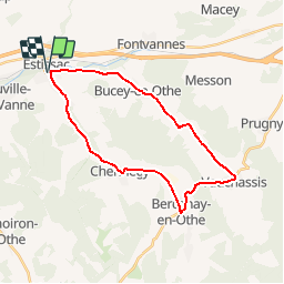
Tour Fahrrad von 25 km verfügbar auf Großer Osten, Aube, Estissac. Diese Tour wird von tracegps vorgeschlagen.
Beschreibung
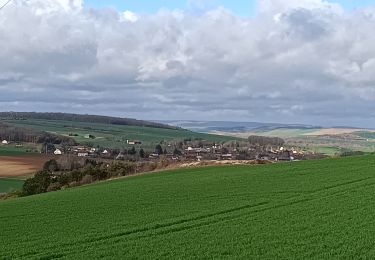
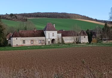
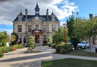
Circuit proposé par l'office de Tourisme du Pays d'Othe, vallée de la Vanne et le Cyclo Club Othéen. Départ place de la mairie d'Etissac. La halle d'Estissac fut dressée durant la première partie du XVIIIème siècle en tant qu'élément du domaine seigneurial. Elle sert d'abri au pressoir et sert également de lieu de marché à grains et de foires. La municipalité l'achète en 1801. Un marché s'y tient le dimanche matin depuis le XXème siècle. Retrouvez le circuit a télécharger sur le site de l'office de tourisme du Pays d'Othe, vallée de la Vanne.
Ort
Kommentare
Touren in der Umgebung
![Tour Wandern Bucey-en-Othe - Au dessus de BUCEY EN OTHE - Photo](https://media.geolcdn.com/t/375/260/35008645-73de-4efb-a96c-d0d684570ae0.jpg&format=jpg&maxdim=2)
![Wandern Wandern](https://static1.geolcdn.com/sitytour/trail-icons/101.png)
Wandern
![](/images/other/stat-length.png)
![](https://static1.geolcdn.com/siteimages/upload/files/16400158638029165_repeat_loop_refresh_sync_direction_icon.png)
![Tour Wandern Bucey-en-Othe - Bucey en Othe - Photo](https://media.geolcdn.com/t/375/260/5c3adecb-99f2-402f-8840-28b9ce614624.jpg&format=jpg&maxdim=2)
![Wandern Wandern](https://static1.geolcdn.com/sitytour/trail-icons/101.png)
Wandern
![](/images/other/stat-length.png)
![](https://static1.geolcdn.com/siteimages/upload/files/16400158638029165_repeat_loop_refresh_sync_direction_icon.png)
![Tour Wandern Chennegy - Randonnée à Chennegy - Photo](https://media.geolcdn.com/t/375/260/666caa5e-9668-4e17-9e4d-980944e36ad5.jpg&format=jpg&maxdim=2)
![Wandern Wandern](https://static1.geolcdn.com/sitytour/trail-icons/101.png)
Wandern
![](/images/other/stat-length.png)
![](https://static1.geolcdn.com/siteimages/upload/files/16400158638029165_repeat_loop_refresh_sync_direction_icon.png)
![Tour Wandern Bucey-en-Othe - Balade autour de Bicey - Photo](https://media.geolcdn.com/t/375/260/98615ad1-cbf1-4979-baef-35b7e1343f2e.jpg&format=jpg&maxdim=2)
![Wandern Wandern](https://static1.geolcdn.com/sitytour/trail-icons/101.png)
Wandern
![](/images/other/stat-length.png)
![](https://static1.geolcdn.com/siteimages/upload/files/16400158638029165_repeat_loop_refresh_sync_direction_icon.png)
![Tour Wandern Bucey-en-Othe - Bucey en Othe - Photo](https://media.geolcdn.com/t/375/260/3a00c592-7942-4888-b55e-9a28bdf9eb19.jpg&format=jpg&maxdim=2)
![Wandern Wandern](https://static1.geolcdn.com/sitytour/trail-icons/101.png)
Wandern
![](/images/other/stat-length.png)
![](https://static1.geolcdn.com/siteimages/upload/files/16400158638029165_repeat_loop_refresh_sync_direction_icon.png)
![Tour Wandern Estissac - Randonnée Bucey 01 août, 2023 - Photo](https://media.geolcdn.com/t/375/260/73372dab-7bdc-4eae-ba52-6410be568c17.jpg&format=jpg&maxdim=2)
![Wandern Wandern](https://static1.geolcdn.com/sitytour/trail-icons/101.png)
Wandern
![](/images/other/stat-length.png)
![](https://static1.geolcdn.com/siteimages/upload/files/16400158638029165_repeat_loop_refresh_sync_direction_icon.png)
![Tour Wandern Estissac - Randonnée Club - Photo](https://media.geolcdn.com/t/375/260/3f183a86-fb71-4e1c-bc68-3aefbf52e304.jpg&format=jpg&maxdim=2)
![Wandern Wandern](https://static1.geolcdn.com/sitytour/trail-icons/101.png)
Wandern
![](/images/other/stat-length.png)
![](https://static1.geolcdn.com/siteimages/upload/files/16400158638029165_repeat_loop_refresh_sync_direction_icon.png)
![Tour Rennrad Estissac - EXT125 Estissac-01 - Photo](https://media.geolcdn.com/t/375/260/ac8a0968-d794-4f70-8e18-1fd419623ff1.jpg&format=jpg&maxdim=2)
![Rennrad Rennrad](https://static1.geolcdn.com/sitytour/trail-icons/201.png)
Rennrad
![](/images/other/stat-length.png)
![](https://static1.geolcdn.com/siteimages/upload/files/16400158638029165_repeat_loop_refresh_sync_direction_icon.png)
![Tour Wandern Bucey-en-Othe - Au dessus de Bucey et Messon - Photo](https://media.geolcdn.com/t/375/260/60700a73-91d2-41e6-ac18-57bc0b49cc95.jpg&format=jpg&maxdim=2)
![Wandern Wandern](https://static1.geolcdn.com/sitytour/trail-icons/101.png)
Wandern
![](/images/other/stat-length.png)
![](https://static1.geolcdn.com/siteimages/upload/files/16400158638029165_repeat_loop_refresh_sync_direction_icon.png)