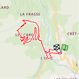
![](/images/other/stat-length.png)
![Tour Wandern Beaufort - La Boucle des Carroz - Arêches - Photo](https://media.geolcdn.com/t/1900/400/ext.pjpeg?maxdim=2&url=https%3A%2F%2Fservices.sitytrail.com%2FGeolivesWS%2FDownloadMedia.ashx%3FTrailID%3D112704%26Media%3D11559_4.jpg)
La Boucle des Carroz - Arêches
tracegps
Benutzer
![Länge](/images/other/stat-length.png)
![Maximale Höhe](https://static1.geolcdn.com/siteimages/upload/files/1508320355ic_sort_altitude_max_24dp.png)
![Positive Höhendifferenz](https://static1.geolcdn.com/siteimages/upload/files/1508320355ic_sort_den_pos_24dp.png)
![Km-Effort](/images/other/stat-length.png)
![Min. Höhe](https://static1.geolcdn.com/siteimages/upload/files/1508320355ic_sort_altitude_min_24dp.png)
![Negative Höhendifferenz](https://static1.geolcdn.com/siteimages/upload/files/1508320355ic_sort_den_neg_24dp.png)
![Boucle](https://static1.geolcdn.com/siteimages/upload/files/16400158638029165_repeat_loop_refresh_sync_direction_icon.png)
![Wandern](https://static1.geolcdn.com/sitytour/trail-icons/101.png)
2h30
Schwierigkeit : Medium
![Scannen Sie diesen QR-Code, um die Tour in der SityTrail-Anwendung zu öffnen](https://capi.geolives.com/qq0zvz2zws4bq2lad0pu/sitytour/trails/112704/qr.png?size=200)
Kostenlosegpshiking-Anwendung
Über SityTrail
Tour Wandern von 4,8 km verfügbar auf Auvergne-Rhone-Alpen, Savoyen, Beaufort. Diese Tour wird von tracegps vorgeschlagen.
Beschreibung
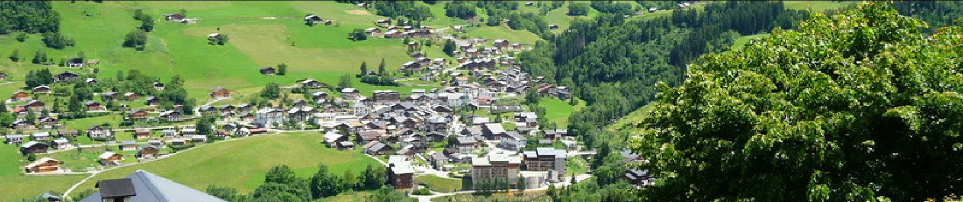
Au cœur des versants verdoyants, et des forêts, Arèches est un village typique qui vit à l’année au son des clochettes des troupeaux et au rythme des sportifs les plus passionnés. Arêches a su garder son âme, son architecture traditionnelle et son identité. Au printemps, il n’est pas rare en effet de croiser quelques beaux troupeaux de tarines, avant leur départ en alpages. A découvrir sans faute : l’église St Jean Baptiste de style baroque savoyard, le chalet-exposition La Ruine, sans oublier les cadrans solaires, les chapelles, les greniers et les oratoires que l’on admire en flânant au hasard des ruelles étroites et des passages au cœur du village. Le village est très commerçant : bars, restaurants, hôtels, villages vacances poste, mairie annexe, distributeur automatique, boulangeries, boucherie-traiteur, épiceries, presse, tabac, souvenirs, magasins de décoration, agences immobilières, produits du terroir, photographe, magasins de sports. Nombreux sont les hameaux disséminés autour d’Arêches, avec chacun son oratoire, et sa chapelle. L’association du bois et de la pierre est de règle ici comme partout dans l’architecture beaufortaine, et on ne manquera pas de remarquer en façade les tas de bois savamment empilés, véritable bonheur dans l’esthétique des chalets. Départ : Arêches
Ort
Kommentare
Touren in der Umgebung
![Tour Fahrrad Villard-sur-Doron - Boucle Villars le Mont Crest Voland Les Saisies - Photo](https://media.geolcdn.com/t/375/260/ext.jpg?maxdim=2&url=https%3A%2F%2Fservices.sitytrail.com%2FGeolivesWS%2FDownloadMedia.ashx%3FTrailID%3D855162%26Media%3D20171031161248.jpg)
![Fahrrad Fahrrad](https://static1.geolcdn.com/sitytour/trail-icons/200.png)
Fahrrad
![](/images/other/stat-length.png)
![](https://static1.geolcdn.com/siteimages/upload/files/16400158638029165_repeat_loop_refresh_sync_direction_icon.png)
![Tour Wandern Beaufort - D'Arêches au Col de Pré par le hameau de Boudin - Photo](https://media.geolcdn.com/t/375/260/ext.jpg?maxdim=2&url=https%3A%2F%2Fservices.sitytrail.com%2FGeolivesWS%2FDownloadMedia.ashx%3FTrailID%3D112688%26Media%3D11533_5.jpg)
![Wandern Wandern](https://static1.geolcdn.com/sitytour/trail-icons/101.png)
Wandern
![](/images/other/stat-length.png)
![](https://static1.geolcdn.com/siteimages/upload/files/16400158638029165_repeat_loop_refresh_sync_direction_icon.png)
![Tour Wandern Beaufort - Arêches Cuvy - Photo](https://media.geolcdn.com/t/375/260/ext.jpg?maxdim=2&url=https%3A%2F%2Fstatic1.geolcdn.com%2Fsiteimages%2Fupload%2Ffiles%2F1553511878bg_sport_marche.png)
![Wandern Wandern](https://static1.geolcdn.com/sitytour/trail-icons/101.png)
Wandern
![](/images/other/stat-length.png)
![](https://static1.geolcdn.com/siteimages/upload/files/16400158638029165_repeat_loop_refresh_sync_direction_icon.png)
![Tour Wandern Beaufort - suuntoapp-Hiking-2024-09-07T06-03-31Z - Photo](https://media.geolcdn.com/t/375/260/1c7a5e77-787c-4d14-8dd4-f96128769e9c.jpg&format=jpg&maxdim=2)
![Wandern Wandern](https://static1.geolcdn.com/sitytour/trail-icons/101.png)
Wandern
![](/images/other/stat-length.png)
![](https://static1.geolcdn.com/siteimages/upload/files/16400158638029165_repeat_loop_refresh_sync_direction_icon.png)
![Tour Skiwanderen Beaufort - Anticime de la pointe de la grande journée, montée couloir du grepets - Photo](https://media.geolcdn.com/t/375/260/8dfd1937-3bd4-42bd-a4fa-284d4bb8802e.jpg&format=jpg&maxdim=2)
![Skiwanderen Skiwanderen](https://static1.geolcdn.com/sitytour/trail-icons/503.png)
Skiwanderen
![](/images/other/stat-length.png)
![](https://static1.geolcdn.com/siteimages/upload/files/16400158638029165_repeat_loop_refresh_sync_direction_icon.png)
![Tour Skiwanderen Beaufort - Côte 2000 et col de Roche plane - Photo](https://media.geolcdn.com/t/375/260/38a11e49-5450-4382-89d2-44ae6ea43162.jpg&format=jpg&maxdim=2)
![Skiwanderen Skiwanderen](https://static1.geolcdn.com/sitytour/trail-icons/503.png)
Skiwanderen
![](/images/other/stat-length.png)
![](https://static1.geolcdn.com/siteimages/upload/files/16400158638029165_repeat_loop_refresh_sync_direction_icon.png)
![Tour Wandern Beaufort - Barrage St Guerin Refuge de l’Econdu 12 km - 600 m d’en + - Photo](https://media.geolcdn.com/t/375/260/e237980d-0989-4662-bd24-20be909d7e5b.jpg&format=jpg&maxdim=2)
![Wandern Wandern](https://static1.geolcdn.com/sitytour/trail-icons/101.png)
Wandern
![](/images/other/stat-length.png)
![](https://static1.geolcdn.com/siteimages/upload/files/16400158638029165_repeat_loop_refresh_sync_direction_icon.png)
![Tour Wandern Beaufort - Le pas de l’âne 10 km 850 m dénivelé + - Photo](https://media.geolcdn.com/t/375/260/e16223c0-d24b-4318-beff-cfc74b9fa02c.jpg&format=jpg&maxdim=2)
![Wandern Wandern](https://static1.geolcdn.com/sitytour/trail-icons/101.png)
Wandern
![](/images/other/stat-length.png)
![](https://static1.geolcdn.com/siteimages/upload/files/16400158638029165_repeat_loop_refresh_sync_direction_icon.png)
![Tour Wandern Beaufort - Roche Pastrire 8,7 km - Photo](https://media.geolcdn.com/t/375/260/783675ed-dc1c-4b41-82f9-ac57164bc294.jpg&format=jpg&maxdim=2)
![Wandern Wandern](https://static1.geolcdn.com/sitytour/trail-icons/101.png)
Wandern
![](/images/other/stat-length.png)
![](https://static1.geolcdn.com/siteimages/upload/files/16400158638029165_repeat_loop_refresh_sync_direction_icon.png)