![](/images/other/stat-length.png)
![Tour Mountainbike Preyssac-d'Excideuil - Boucle du tacot à Preyssac d'Excideuil - Photo](https://media.geolcdn.com/t/1900/400/ext.pjpeg?maxdim=2&url=https%3A%2F%2Fservices.sitytrail.com%2FGeolivesWS%2FDownloadMedia.ashx%3FTrailID%3D112551%26Media%3D10796_5.jpg)
Boucle du tacot à Preyssac d'Excideuil
tracegps
Benutzer
![Länge](/images/other/stat-length.png)
![Maximale Höhe](https://static1.geolcdn.com/siteimages/upload/files/1508320355ic_sort_altitude_max_24dp.png)
![Positive Höhendifferenz](https://static1.geolcdn.com/siteimages/upload/files/1508320355ic_sort_den_pos_24dp.png)
![Km-Effort](/images/other/stat-length.png)
![Min. Höhe](https://static1.geolcdn.com/siteimages/upload/files/1508320355ic_sort_altitude_min_24dp.png)
![Negative Höhendifferenz](https://static1.geolcdn.com/siteimages/upload/files/1508320355ic_sort_den_neg_24dp.png)
![Boucle](https://static1.geolcdn.com/siteimages/upload/files/16400158638029165_repeat_loop_refresh_sync_direction_icon.png)
![Mountainbike](https://static1.geolcdn.com/sitytour/trail-icons/202.png)
1h00
Schwierigkeit : Einfach
![Scannen Sie diesen QR-Code, um die Tour in der SityTrail-Anwendung zu öffnen](https://capi.geolives.com/qq0zvz2zws4bq2lad0pu/sitytour/trails/112551/qr.png?size=200)
Kostenlosegpshiking-Anwendung
Über SityTrail
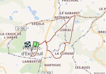
Tour Mountainbike von 7,9 km verfügbar auf Neu-Aquitanien, Dordogne, Preyssac-d'Excideuil. Diese Tour wird von tracegps vorgeschlagen.
Beschreibung
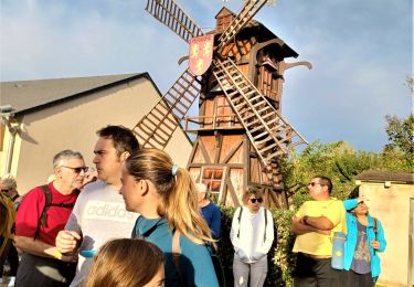
Circuit proposé par le comité d'animation touristique et culturelle du Pays de Lanouaille. Départ place de l’église au clocher-mur du XIIIème siècle. Ancienne gare du « tacot » qui va être restaurée par la commune. Le « tacot » était un petit train qui parcourut la ligne Périgueux-Saint-Yrieix-la-Perche de 1887 à 1949. L’ancienne voie fut aménagée en route ou chemin ou achetée par des particuliers. Le circuit emprunte aussi une ancienne route rectiligne dite « Napoléon » (Limoges Cahors) peut-être d’origine romaine à travers bois. Retour en surplomb du village et son lavoir à « banches » de pierre.
Ort
Kommentare
Touren in der Umgebung
![Tour Wandern Saint-Raphaël - St Raphaël variante Pontillau Qincallou10km - Photo](https://media.geolcdn.com/t/375/260/ext.jpg?maxdim=2&url=https%3A%2F%2Fstatic1.geolcdn.com%2Fsiteimages%2Fupload%2Ffiles%2F1553511878bg_sport_marche.png)
![Wandern Wandern](https://static1.geolcdn.com/sitytour/trail-icons/101.png)
Wandern
![](/images/other/stat-length.png)
![](https://static1.geolcdn.com/siteimages/upload/files/16400158638029165_repeat_loop_refresh_sync_direction_icon.png)
![Tour Wandern Excideuil - boucle spéciale Excideuil - Photo](https://media.geolcdn.com/t/375/260/06d13133-8da9-4edc-ae99-e0fd7dec2882.jpg&format=jpg&maxdim=2)
![Wandern Wandern](https://static1.geolcdn.com/sitytour/trail-icons/101.png)
Wandern
![](/images/other/stat-length.png)
![](https://static1.geolcdn.com/siteimages/upload/files/16400158638029165_repeat_loop_refresh_sync_direction_icon.png)
![Tour Wandern Preyssac-d'Excideuil - Boucle du tacot à Preyssac d'Excideuil - Photo](https://media.geolcdn.com/t/375/260/ext.jpg?maxdim=2&url=https%3A%2F%2Fservices.sitytrail.com%2FGeolivesWS%2FDownloadMedia.ashx%3FTrailID%3D112550%26Media%3D10796_5.jpg)
![Wandern Wandern](https://static1.geolcdn.com/sitytour/trail-icons/101.png)
Wandern
![](/images/other/stat-length.png)
![](https://static1.geolcdn.com/siteimages/upload/files/16400158638029165_repeat_loop_refresh_sync_direction_icon.png)
![Tour Wandern Excideuil - Sentier Karstique les Roches Enchantées - Excideuil - Photo](https://media.geolcdn.com/t/375/260/ext.jpg?maxdim=2&url=https%3A%2F%2Fservices.sitytrail.com%2FGeolivesWS%2FDownloadMedia.ashx%3FTrailID%3D106062%26Media%3D10205_3.jpg)
![Wandern Wandern](https://static1.geolcdn.com/sitytour/trail-icons/101.png)
Wandern
![](/images/other/stat-length.png)
![](https://static1.geolcdn.com/siteimages/upload/files/16400158638029165_repeat_loop_refresh_sync_direction_icon.png)
![Tour Wandern Génis - Rand'Auvezere - Photo](https://media.geolcdn.com/t/375/260/bdcd3d06-cbea-46a9-b180-c7c5bb9d4a09.jpg&format=jpg&maxdim=2)
![Wandern Wandern](https://static1.geolcdn.com/sitytour/trail-icons/101.png)
Wandern
![](/images/other/stat-length.png)
![](https://static1.geolcdn.com/siteimages/upload/files/16400158638029165_repeat_loop_refresh_sync_direction_icon.png)
![Tour Wandern Anlhiac - petite boucle - Photo](https://media.geolcdn.com/t/375/260/327402eb-5e92-4702-8fd9-52eeff6b5382.jpg&format=jpg&maxdim=2)
![Wandern Wandern](https://static1.geolcdn.com/sitytour/trail-icons/101.png)
Wandern
![](/images/other/stat-length.png)
![](https://static1.geolcdn.com/siteimages/upload/files/16400158638029165_repeat_loop_refresh_sync_direction_icon.png)
![Tour Wandern Excideuil - Boucle d'Excideuil - Photo](https://media.geolcdn.com/t/375/260/d4842b85-2d0f-436e-92aa-0848043a041d.jpg&format=jpg&maxdim=2)
![Wandern Wandern](https://static1.geolcdn.com/sitytour/trail-icons/101.png)
Wandern
![](/images/other/stat-length.png)
![](https://static1.geolcdn.com/siteimages/upload/files/16400158638029165_repeat_loop_refresh_sync_direction_icon.png)
![Tour Zu Fuß Excideuil - Excideuil les chemins des meuniers - Photo](https://media.geolcdn.com/t/375/260/52f3ffc3-bcdb-4ffd-a068-070b5152d563.jpg&format=jpg&maxdim=2)
![Zu Fuß Zu Fuß](https://static1.geolcdn.com/sitytour/trail-icons/100.png)
Zu Fuß
![](/images/other/stat-length.png)
![](https://static1.geolcdn.com/siteimages/upload/files/16400158638029165_repeat_loop_refresh_sync_direction_icon.png)
![Tour Wandern Anlhiac - dudule - Photo](https://media.geolcdn.com/t/375/260/b9c90d50-691e-4dd4-b259-bf16e4910606.jpg&format=jpg&maxdim=2)
![Wandern Wandern](https://static1.geolcdn.com/sitytour/trail-icons/101.png)
Wandern
![](/images/other/stat-length.png)
![](https://static1.geolcdn.com/siteimages/upload/files/16400158638029165_repeat_loop_refresh_sync_direction_icon.png)