![](/images/other/stat-length.png)
![Tour Mountainbike Saint-Merd-les-Oussines - Du site des Cars à la tourbière du Longeyroux - Saint Merd les Oussines - Pays de Haute Corrèze - Photo](https://media.geolcdn.com/t/1900/400/ext.pjpeg?maxdim=2&url=https%3A%2F%2Fservices.sitytrail.com%2FGeolivesWS%2FDownloadMedia.ashx%3FTrailID%3D112415%26Media%3D10534_1.jpg)
Du site des Cars à la tourbière du Longeyroux - Saint Merd les Oussines - Pays de Haute Corrèze
tracegps
Benutzer
![Länge](/images/other/stat-length.png)
![Maximale Höhe](https://static1.geolcdn.com/siteimages/upload/files/1508320355ic_sort_altitude_max_24dp.png)
![Positive Höhendifferenz](https://static1.geolcdn.com/siteimages/upload/files/1508320355ic_sort_den_pos_24dp.png)
![Km-Effort](/images/other/stat-length.png)
![Min. Höhe](https://static1.geolcdn.com/siteimages/upload/files/1508320355ic_sort_altitude_min_24dp.png)
![Negative Höhendifferenz](https://static1.geolcdn.com/siteimages/upload/files/1508320355ic_sort_den_neg_24dp.png)
![Boucle](https://static1.geolcdn.com/siteimages/upload/files/16400158638029165_repeat_loop_refresh_sync_direction_icon.png)
![Mountainbike](https://static1.geolcdn.com/sitytour/trail-icons/202.png)
1h15
Schwierigkeit : Medium
![Scannen Sie diesen QR-Code, um die Tour in der SityTrail-Anwendung zu öffnen](https://capi.geolives.com/qq0zvz2zws4bq2lad0pu/sitytour/trails/112415/qr.png?size=200)
Kostenlosegpshiking-Anwendung
Über SityTrail
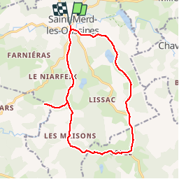
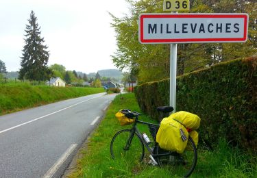
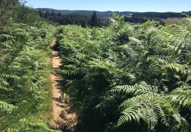
Tour Mountainbike von 16,1 km verfügbar auf Neu-Aquitanien, Corrèze, Saint-Merd-les-Oussines. Diese Tour wird von tracegps vorgeschlagen.
Beschreibung
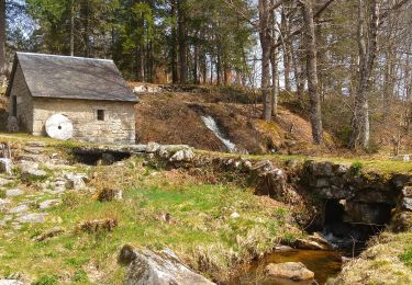
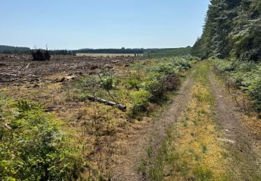
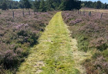
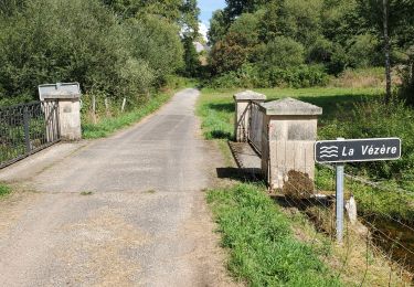
Du site des Cars à la tourbière du Longeyroux - Saint Merd les Oussines - Pays de Haute Corrèze. Au programme de la balade, seux sites emblématiques du Plateau de Millevaches ; les vestiges des Cars, éléments d’un vaste domaine agricole gallo-romain, et la Tourbière du Longeyroux. Un sentier d’interprétation au départ du parking vous permettra d’en faire le tour. Autre élément de patrimoine, le moulin sectionnal des Maisons a été restauré de manière remarquable par la commune. Téléchargez la fiche du circuit sur le site du Conseil Général de la Corrèze. Renseignements : Office de Tourisme de Burgeat 05.55.95.18.68
Ort
Kommentare
Touren in der Umgebung
![Tour Wandern Saint-Merd-les-Oussines - Du site des Cars à la tourbière du Longeyroux - Saint Merd les Oussines - Pays de Haute Corrèze - Photo](https://media.geolcdn.com/t/375/260/ext.jpg?maxdim=2&url=https%3A%2F%2Fservices.sitytrail.com%2FGeolivesWS%2FDownloadMedia.ashx%3FTrailID%3D112414%26Media%3D10534_1.jpg)
![Wandern Wandern](https://static1.geolcdn.com/sitytour/trail-icons/101.png)
Wandern
![](/images/other/stat-length.png)
![](https://static1.geolcdn.com/siteimages/upload/files/16400158638029165_repeat_loop_refresh_sync_direction_icon.png)
![Tour Wandern Saint-Merd-les-Oussines - Le sentier des bruyères - Photo](https://media.geolcdn.com/t/375/260/488e30cf-5719-4904-be7c-482bc296e152.jpg&format=jpg&maxdim=2)
![Wandern Wandern](https://static1.geolcdn.com/sitytour/trail-icons/101.png)
Wandern
![](/images/other/stat-length.png)
![](https://static1.geolcdn.com/siteimages/upload/files/16400158638029165_repeat_loop_refresh_sync_direction_icon.png)
![Tour Wandern Saint-Merd-les-Oussines - Autour de la Tourbière - Photo](https://media.geolcdn.com/t/375/260/ext.jpg?maxdim=2&url=https%3A%2F%2Fstatic1.geolcdn.com%2Fsiteimages%2Fupload%2Ffiles%2F1553511878bg_sport_marche.png)
![Wandern Wandern](https://static1.geolcdn.com/sitytour/trail-icons/101.png)
Wandern
![](/images/other/stat-length.png)
![](https://static1.geolcdn.com/siteimages/upload/files/16400158638029165_repeat_loop_refresh_sync_direction_icon.png)
![Tour Wandern Pérols-sur-Vézère - Varieras_Razel - Photo](https://media.geolcdn.com/t/375/260/75ddd4c0-d750-454a-b4b1-a1ae60b47837.jpg&format=jpg&maxdim=2)
![Wandern Wandern](https://static1.geolcdn.com/sitytour/trail-icons/101.png)
Wandern
![](/images/other/stat-length.png)
![](https://static1.geolcdn.com/siteimages/upload/files/16400158638029165_repeat_loop_refresh_sync_direction_icon.png)
![Tour sport Saint-Merd-les-Oussines - F 2024?Longeyroux Lac Oussines - Photo](https://media.geolcdn.com/t/375/260/aa2d07db-3b65-4ec1-88c3-11e9ca3779dd.jpg&format=jpg&maxdim=2)
sport
![](/images/other/stat-length.png)
![](https://static1.geolcdn.com/siteimages/upload/files/16400158638029165_repeat_loop_refresh_sync_direction_icon.png)
![Tour sport Saint-Merd-les-Oussines - Longeyroux Les Oussines - Photo](https://media.geolcdn.com/t/375/260/9abf5d9f-9b93-4ec8-90f0-993364c0b57e.jpg&format=jpg&maxdim=2)
sport
![](/images/other/stat-length.png)
![](https://static1.geolcdn.com/siteimages/upload/files/16400158638029165_repeat_loop_refresh_sync_direction_icon.png)
![Tour Wandern Chavanac - chavanac_les Oussines - Photo](https://media.geolcdn.com/t/375/260/e2c65ba9-7a26-45bf-85fc-105551dde7c2.jpg&format=jpg&maxdim=2)
![Wandern Wandern](https://static1.geolcdn.com/sitytour/trail-icons/101.png)
Wandern
![](/images/other/stat-length.png)
![](https://static1.geolcdn.com/siteimages/upload/files/16400158638029165_repeat_loop_refresh_sync_direction_icon.png)
![Tour Zu Fuß Millevaches - Sentier du puy des Pouges - Photo](https://media.geolcdn.com/t/375/260/6fd9e205-7ee1-47c1-890a-3e120b798d14.jpeg&format=jpg&maxdim=2)
![Zu Fuß Zu Fuß](https://static1.geolcdn.com/sitytour/trail-icons/100.png)
Zu Fuß
![](/images/other/stat-length.png)
![](https://static1.geolcdn.com/siteimages/upload/files/16400158638029165_repeat_loop_refresh_sync_direction_icon.png)
![Tour Wandern Saint-Merd-les-Oussines - Correze Mille Vache Longeyroux - Photo](https://media.geolcdn.com/t/375/260/0c1cc9e4-88c4-47ba-a350-5c1a428eadf1.jpg&format=jpg&maxdim=2)
![Wandern Wandern](https://static1.geolcdn.com/sitytour/trail-icons/101.png)
Wandern
![](/images/other/stat-length.png)
![](https://static1.geolcdn.com/siteimages/upload/files/16400158638029165_repeat_loop_refresh_sync_direction_icon.png)