![](/images/other/stat-length.png)
![Tour Wandern Val d'Arcomie - Grand Tour de Faverolles - Photo](https://media.geolcdn.com/t/1900/400/ext.pjpeg?maxdim=2&url=https%3A%2F%2Fservices.sitytrail.com%2FGeolivesWS%2FDownloadMedia.ashx%3FTrailID%3D112263%26Media%3D10252_5.jpg)
Grand Tour de Faverolles
tracegps
Benutzer
![Länge](/images/other/stat-length.png)
Länge
10,3 km
![Maximale Höhe](https://static1.geolcdn.com/siteimages/upload/files/1508320355ic_sort_altitude_max_24dp.png)
Maximale Höhe
989 m
![Positive Höhendifferenz](https://static1.geolcdn.com/siteimages/upload/files/1508320355ic_sort_den_pos_24dp.png)
Positive Höhendifferenz
250 m
![Km-Effort](/images/other/stat-length.png)
Km-Effort
13,7 km
![Min. Höhe](https://static1.geolcdn.com/siteimages/upload/files/1508320355ic_sort_altitude_min_24dp.png)
Min. Höhe
805 m
![Negative Höhendifferenz](https://static1.geolcdn.com/siteimages/upload/files/1508320355ic_sort_den_neg_24dp.png)
Negative Höhendifferenz
251 m
![Boucle](https://static1.geolcdn.com/siteimages/upload/files/16400158638029165_repeat_loop_refresh_sync_direction_icon.png)
Boucle
Ja
Erstellungsdatum :
2014-12-10 00:00:00.0
Letzte Änderung :
2014-12-10 00:00:00.0
![Wandern](https://static1.geolcdn.com/sitytour/trail-icons/101.png)
2h34
Schwierigkeit : Medium
![Scannen Sie diesen QR-Code, um die Tour in der SityTrail-Anwendung zu öffnen](https://capi.geolives.com/qq0zvz2zws4bq2lad0pu/sitytour/trails/112263/qr.png?size=200)
Kostenlosegpshiking-Anwendung
Über SityTrail
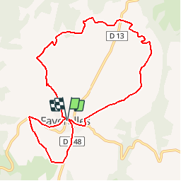
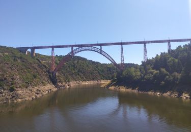
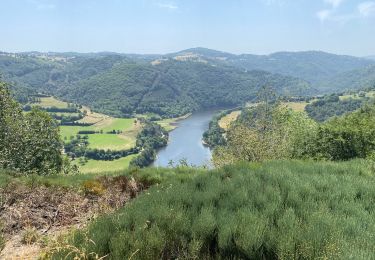
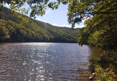
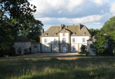
Tour Wandern von 10,3 km verfügbar auf Auvergne-Rhone-Alpen, Cantal, Val d'Arcomie. Diese Tour wird von tracegps vorgeschlagen.
Beschreibung
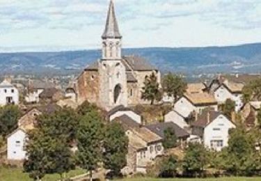
Circuit proposé par la commune de Faverolles. Départ de la place de la mairie. Retrouvez le plan et le descriptif sur le site de la commune de Faverolles.
Ort
Land:
France
Region :
Auvergne-Rhone-Alpen
Abteilung/Provinz :
Cantal
Kommune :
Val d'Arcomie
Standort:
Faverolles
Gehen Sie:(Dec)
Gehen Sie:(UTM)
511552 ; 4976345 (31T) N.
Kommentare
Touren in der Umgebung
![Tour Wandern Fridefont - Magnac - Photo](https://media.geolcdn.com/t/375/260/ext.jpg?maxdim=2&url=https%3A%2F%2Fmedia.geolcdn.com%2Ff%2Fbd259a51-4b76-408c-92e2-ca82a9517d42.jpg)
![Wandern Wandern](https://static1.geolcdn.com/sitytour/trail-icons/101.png)
Magnac
Wandern
Medium
Fridefont,
Auvergne-Rhone-Alpen,
Cantal,
France
![](/images/other/stat-length.png)
10,3 km | 14,4 km-effort
3h 5min
![](https://static1.geolcdn.com/siteimages/upload/files/16400158638029165_repeat_loop_refresh_sync_direction_icon.png)
Ja
![Tour Wandern Val d'Arcomie - Circuit Margeride Truyère - Saint Marc et Saint Just - Photo](https://media.geolcdn.com/t/375/260/ext.jpg?maxdim=2&url=https%3A%2F%2Fstatic1.geolcdn.com%2Fsiteimages%2Fupload%2Ffiles%2F1553511878bg_sport_marche.png)
![Wandern Wandern](https://static1.geolcdn.com/sitytour/trail-icons/101.png)
Circuit Margeride Truyère - Saint Marc et Saint Just
Wandern
Medium
(1)
Val d'Arcomie,
Auvergne-Rhone-Alpen,
Cantal,
France
![](/images/other/stat-length.png)
14,7 km | 18,8 km-effort
3h 25min
![](https://static1.geolcdn.com/siteimages/upload/files/16400158638029165_repeat_loop_refresh_sync_direction_icon.png)
Ja
![Tour Wandern Fridefont - Magnan - Photo](https://media.geolcdn.com/t/375/260/ext.jpg?maxdim=2&url=https%3A%2F%2Fmedia.geolcdn.com%2Ff%2F3a9b6554-8053-4aed-ad8a-158ccb895998.jpg)
![Wandern Wandern](https://static1.geolcdn.com/sitytour/trail-icons/101.png)
Magnan
Wandern
Schwierig
Fridefont,
Auvergne-Rhone-Alpen,
Cantal,
France
![](/images/other/stat-length.png)
10,1 km | 14,2 km-effort
3h 39min
![](https://static1.geolcdn.com/siteimages/upload/files/16400158638029165_repeat_loop_refresh_sync_direction_icon.png)
Ja
![Tour Wandern Fridefont - Les gorges de Bès - Photo](https://media.geolcdn.com/t/375/260/ext.jpg?maxdim=2&url=https%3A%2F%2Fmedia.geolcdn.com%2Ff%2F355a8234-906c-48fe-a1fa-b94a4304f223.jpg)
![Wandern Wandern](https://static1.geolcdn.com/sitytour/trail-icons/101.png)
Les gorges de Bès
Wandern
Einfach
Fridefont,
Auvergne-Rhone-Alpen,
Cantal,
France
![](/images/other/stat-length.png)
17,6 km | 24 km-effort
2h 40min
![](https://static1.geolcdn.com/siteimages/upload/files/16400158638029165_repeat_loop_refresh_sync_direction_icon.png)
Nein
![Tour Rennrad Fridefont - La vallée de Truyère - Photo](https://media.geolcdn.com/t/375/260/ext.jpg?maxdim=2&url=https%3A%2F%2Fmedia.geolcdn.com%2Ff%2F7b822ba6-e872-4da7-b587-53102ee447a8.jpg)
![Rennrad Rennrad](https://static1.geolcdn.com/sitytour/trail-icons/201.png)
La vallée de Truyère
Rennrad
Medium
Fridefont,
Auvergne-Rhone-Alpen,
Cantal,
France
![](/images/other/stat-length.png)
56 km | 73 km-effort
3h 44min
![](https://static1.geolcdn.com/siteimages/upload/files/16400158638029165_repeat_loop_refresh_sync_direction_icon.png)
Nein
![Tour Mountainbike Val d'Arcomie - Petit Circuit panoramique - Faverolles - Photo](https://media.geolcdn.com/t/375/260/ext.jpg?maxdim=2&url=https%3A%2F%2Fservices.sitytrail.com%2FGeolivesWS%2FDownloadMedia.ashx%3FTrailID%3D112378%26Media%3D10506_5.jpg)
![Mountainbike Mountainbike](https://static1.geolcdn.com/sitytour/trail-icons/202.png)
Petit Circuit panoramique - Faverolles
Mountainbike
Einfach
Val d'Arcomie,
Auvergne-Rhone-Alpen,
Cantal,
France
![](/images/other/stat-length.png)
4,4 km | 6,1 km-effort
19min
![](https://static1.geolcdn.com/siteimages/upload/files/16400158638029165_repeat_loop_refresh_sync_direction_icon.png)
Ja
![Tour Wandern Val d'Arcomie - Petit Circuit panoramique - Faverolles - Photo](https://media.geolcdn.com/t/375/260/ext.jpg?maxdim=2&url=https%3A%2F%2Fservices.sitytrail.com%2FGeolivesWS%2FDownloadMedia.ashx%3FTrailID%3D112377%26Media%3D10506_5.jpg)
![Wandern Wandern](https://static1.geolcdn.com/sitytour/trail-icons/101.png)
Petit Circuit panoramique - Faverolles
Wandern
Einfach
Val d'Arcomie,
Auvergne-Rhone-Alpen,
Cantal,
France
![](/images/other/stat-length.png)
4,4 km | 6,1 km-effort
1h 10min
![](https://static1.geolcdn.com/siteimages/upload/files/16400158638029165_repeat_loop_refresh_sync_direction_icon.png)
Ja
![Tour Mountainbike Val d'Arcomie - Grand Tour de Faverolles - Photo](https://media.geolcdn.com/t/375/260/ext.jpg?maxdim=2&url=https%3A%2F%2Fservices.sitytrail.com%2FGeolivesWS%2FDownloadMedia.ashx%3FTrailID%3D112264%26Media%3D10252_5.jpg)
![Mountainbike Mountainbike](https://static1.geolcdn.com/sitytour/trail-icons/202.png)
Grand Tour de Faverolles
Mountainbike
Medium
Val d'Arcomie,
Auvergne-Rhone-Alpen,
Cantal,
France
![](/images/other/stat-length.png)
10,3 km | 13,7 km-effort
1h 0min
![](https://static1.geolcdn.com/siteimages/upload/files/16400158638029165_repeat_loop_refresh_sync_direction_icon.png)
Ja
![Tour Wandern Alleuze - Château d'Alleuze - Barrage Grandval - Photo](https://media.geolcdn.com/t/375/260/ext.jpg?maxdim=2&url=https%3A%2F%2Fservices.sitytrail.com%2FGeolivesWS%2FDownloadMedia.ashx%3FTrailID%3D103757%26Media%3D6498_6.jpg)
![Wandern Wandern](https://static1.geolcdn.com/sitytour/trail-icons/101.png)
Château d'Alleuze - Barrage Grandval
Wandern
Medium
(1)
Alleuze,
Auvergne-Rhone-Alpen,
Cantal,
France
![](/images/other/stat-length.png)
9,6 km | 13,4 km-effort
3h 0min
![](https://static1.geolcdn.com/siteimages/upload/files/16400158638029165_repeat_loop_refresh_sync_direction_icon.png)
Ja