![](/images/other/stat-length.png)
![Tour Wandern La Bastide-Clairence - Tour de La Bastide Clairence - Photo](https://media.geolcdn.com/t/1900/400/ext.pjpeg?maxdim=2&url=https%3A%2F%2Fservices.sitytrail.com%2FGeolivesWS%2FDownloadMedia.ashx%3FTrailID%3D111977%26Media%3D9257_1.jpg)
Tour de La Bastide Clairence
tracegps
Benutzer
![Länge](/images/other/stat-length.png)
Länge
5,2 km
![Maximale Höhe](https://static1.geolcdn.com/siteimages/upload/files/1508320355ic_sort_altitude_max_24dp.png)
Maximale Höhe
119 m
![Positive Höhendifferenz](https://static1.geolcdn.com/siteimages/upload/files/1508320355ic_sort_den_pos_24dp.png)
Positive Höhendifferenz
148 m
![Km-Effort](/images/other/stat-length.png)
Km-Effort
7,1 km
![Min. Höhe](https://static1.geolcdn.com/siteimages/upload/files/1508320355ic_sort_altitude_min_24dp.png)
Min. Höhe
13 m
![Negative Höhendifferenz](https://static1.geolcdn.com/siteimages/upload/files/1508320355ic_sort_den_neg_24dp.png)
Negative Höhendifferenz
148 m
![Boucle](https://static1.geolcdn.com/siteimages/upload/files/16400158638029165_repeat_loop_refresh_sync_direction_icon.png)
Boucle
Ja
Erstellungsdatum :
2014-12-10 00:00:00.0
Letzte Änderung :
2014-12-10 00:00:00.0
![Wandern](https://static1.geolcdn.com/sitytour/trail-icons/101.png)
2h00
Schwierigkeit : Einfach
![Scannen Sie diesen QR-Code, um die Tour in der SityTrail-Anwendung zu öffnen](https://capi.geolives.com/qq0zvz2zws4bq2lad0pu/sitytour/trails/111977/qr.png?size=200)
Kostenlosegpshiking-Anwendung
Über SityTrail
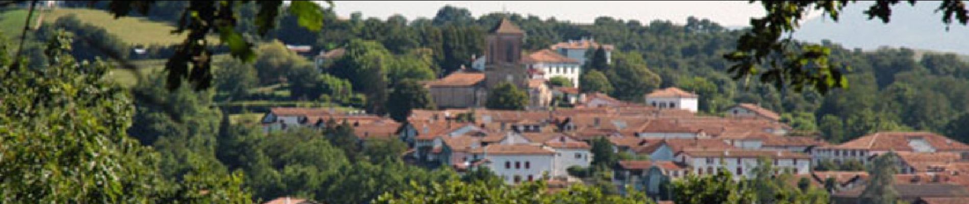
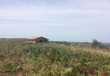
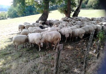
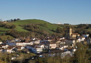
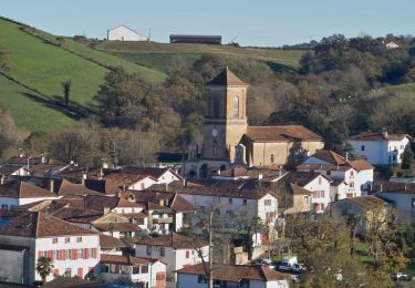
Tour Wandern von 5,2 km verfügbar auf Neu-Aquitanien, Pyrenäen-Atlantik, La Bastide-Clairence. Diese Tour wird von tracegps vorgeschlagen.
Beschreibung
Cette petite randonnée vous fera découvrir le patrimoine bâti remarquable de La Bastide Clairence ainsi que ses coteaux.
Ort
Land:
France
Region :
Neu-Aquitanien
Abteilung/Provinz :
Pyrenäen-Atlantik
Kommune :
La Bastide-Clairence
Standort:
Unknown
Gehen Sie:(Dec)
Gehen Sie:(UTM)
641081 ; 4810305 (30T) N.
Kommentare
Touren in der Umgebung
![Tour Andere Aktivitäten La Bastide-Clairence - Pierroun - Photo](https://media.geolcdn.com/t/375/260/ext.jpg?maxdim=2&url=https%3A%2F%2Fstatic1.geolcdn.com%2Fsiteimages%2Fupload%2Ffiles%2F1545311037marcheuse_200dpi.jpg)
![Andere Aktivitäten Andere Aktivitäten](https://static1.geolcdn.com/sitytour/trail-icons/900.png)
Pierroun
Andere Aktivitäten
Sehr leicht
(1)
La Bastide-Clairence,
Neu-Aquitanien,
Pyrenäen-Atlantik,
France
![](/images/other/stat-length.png)
8,2 km | 11,3 km-effort
2h 0min
![](https://static1.geolcdn.com/siteimages/upload/files/16400158638029165_repeat_loop_refresh_sync_direction_icon.png)
Ja
![Tour Wandern La Bastide-Clairence - Rando des fêtes de Pessarou 2016 - Photo](https://media.geolcdn.com/t/375/260/ext.jpg?maxdim=2&url=https%3A%2F%2Fservices.sitytrail.com%2FGeolivesWS%2FDownloadMedia.ashx%3FTrailID%3D653647%26Media%3D20160904155439.jpg)
![Wandern Wandern](https://static1.geolcdn.com/sitytour/trail-icons/101.png)
Rando des fêtes de Pessarou 2016
Wandern
Einfach
La Bastide-Clairence,
Neu-Aquitanien,
Pyrenäen-Atlantik,
France
![](/images/other/stat-length.png)
13,3 km | 17,9 km-effort
4h 4min
![](https://static1.geolcdn.com/siteimages/upload/files/16400158638029165_repeat_loop_refresh_sync_direction_icon.png)
Ja
![Tour Wandern Ayherre - Ayherre bois - Photo](https://media.geolcdn.com/t/375/260/5ea66a94-168c-487d-8937-29fd298cf15b.jpg&format=jpg&maxdim=2)
![Wandern Wandern](https://static1.geolcdn.com/sitytour/trail-icons/101.png)
Ayherre bois
Wandern
Sehr leicht
Ayherre,
Neu-Aquitanien,
Pyrenäen-Atlantik,
France
![](/images/other/stat-length.png)
9,8 km | 13,6 km-effort
2h 16min
![](https://static1.geolcdn.com/siteimages/upload/files/16400158638029165_repeat_loop_refresh_sync_direction_icon.png)
Ja
![Tour Wandern La Bastide-Clairence - Rando des fêtes de Pessarou 2016 - Photo](https://media.geolcdn.com/t/375/260/ext.jpg?maxdim=2&url=https%3A%2F%2Fservices.sitytrail.com%2FGeolivesWS%2FDownloadMedia.ashx%3FTrailID%3D626267%26Media%3D20160904183435.jpg)
![Wandern Wandern](https://static1.geolcdn.com/sitytour/trail-icons/101.png)
Rando des fêtes de Pessarou 2016
Wandern
Einfach
La Bastide-Clairence,
Neu-Aquitanien,
Pyrenäen-Atlantik,
France
![](/images/other/stat-length.png)
13,3 km | 17,9 km-effort
3h 14min
![](https://static1.geolcdn.com/siteimages/upload/files/16400158638029165_repeat_loop_refresh_sync_direction_icon.png)
Ja
![Tour Andere Aktivitäten Ayherre - Balade du 1-09-13 - Photo](https://media.geolcdn.com/t/375/260/ext.jpg?maxdim=2&url=https%3A%2F%2Fservices.sitytrail.com%2FGeolivesWS%2FDownloadMedia.ashx%3FTrailID%3D220040%26Media%3Dfix__20130901171318.jpg)
![Andere Aktivitäten Andere Aktivitäten](https://static1.geolcdn.com/sitytour/trail-icons/900.png)
Balade du 1-09-13
Andere Aktivitäten
Sehr leicht
Ayherre,
Neu-Aquitanien,
Pyrenäen-Atlantik,
France
![](/images/other/stat-length.png)
9,1 km | 12,2 km-effort
2h 29min
![](https://static1.geolcdn.com/siteimages/upload/files/16400158638029165_repeat_loop_refresh_sync_direction_icon.png)
Ja
![Tour Pferd La Bastide-Clairence - La Bastide Clairence - Pessarou - Photo](https://media.geolcdn.com/t/375/260/ext.jpg?maxdim=2&url=https%3A%2F%2Fservices.sitytrail.com%2FGeolivesWS%2FDownloadMedia.ashx%3FTrailID%3D129952%26Media%3D13510_2.jpg)
![Pferd Pferd](https://static1.geolcdn.com/sitytour/trail-icons/300.png)
La Bastide Clairence - Pessarou
Pferd
Schwierig
La Bastide-Clairence,
Neu-Aquitanien,
Pyrenäen-Atlantik,
France
![](/images/other/stat-length.png)
10,5 km | 14,2 km-effort
Unbekannt
![](https://static1.geolcdn.com/siteimages/upload/files/16400158638029165_repeat_loop_refresh_sync_direction_icon.png)
Nein
![Tour Pferd La Bastide-Clairence - La Bastide Clairence - Hasparren - Photo](https://media.geolcdn.com/t/375/260/ext.jpg?maxdim=2&url=https%3A%2F%2Fservices.sitytrail.com%2FGeolivesWS%2FDownloadMedia.ashx%3FTrailID%3D129946%26Media%3D13503_2.jpg)
![Pferd Pferd](https://static1.geolcdn.com/sitytour/trail-icons/300.png)
La Bastide Clairence - Hasparren
Pferd
Schwierig
La Bastide-Clairence,
Neu-Aquitanien,
Pyrenäen-Atlantik,
France
![](/images/other/stat-length.png)
17,2 km | 24 km-effort
3h 0min
![](https://static1.geolcdn.com/siteimages/upload/files/16400158638029165_repeat_loop_refresh_sync_direction_icon.png)
Nein
![Tour Wandern Ayherre - 2024 10 31 Ayherre - Photo](https://media.geolcdn.com/t/375/260/34db1312-c81a-485a-a3be-f4568e8319d1.jpg&format=jpg&maxdim=2)
![Wandern Wandern](https://static1.geolcdn.com/sitytour/trail-icons/101.png)
2024 10 31 Ayherre
Wandern
Medium
Ayherre,
Neu-Aquitanien,
Pyrenäen-Atlantik,
France
![](/images/other/stat-length.png)
8,1 km | 11 km-effort
1h 57min
![](https://static1.geolcdn.com/siteimages/upload/files/16400158638029165_repeat_loop_refresh_sync_direction_icon.png)
Ja
![Tour Wandern Ayherre - Ayherre 5 - Photo](https://media.geolcdn.com/t/375/260/32c0bf60-708c-44b2-a297-e1b5938f6565.jpg&format=jpg&maxdim=2)
![Wandern Wandern](https://static1.geolcdn.com/sitytour/trail-icons/101.png)
Ayherre 5
Wandern
Medium
Ayherre,
Neu-Aquitanien,
Pyrenäen-Atlantik,
France
![](/images/other/stat-length.png)
5,6 km | 7,2 km-effort
1h 28min
![](https://static1.geolcdn.com/siteimages/upload/files/16400158638029165_repeat_loop_refresh_sync_direction_icon.png)
Ja