![](/images/other/stat-length.png)
![Tour Mountainbike Peyruis - Base VTT FFCT Val de Durance - Les Bancau du champ de Gau - Circuit n°21 - Peyruis - Photo](https://media.geolcdn.com/t/1900/400/ext.pjpeg?maxdim=2&url=https%3A%2F%2Fservices.sitytrail.com%2FGeolivesWS%2FDownloadMedia.ashx%3FTrailID%3D111920%26Media%3D8950_1.jpg)
Base VTT FFCT Val de Durance - Les Bancau du champ de Gau - Circuit n°21 - Peyruis
tracegps
Benutzer
![Länge](/images/other/stat-length.png)
Länge
2,1 km
![Maximale Höhe](https://static1.geolcdn.com/siteimages/upload/files/1508320355ic_sort_altitude_max_24dp.png)
Maximale Höhe
438 m
![Positive Höhendifferenz](https://static1.geolcdn.com/siteimages/upload/files/1508320355ic_sort_den_pos_24dp.png)
Positive Höhendifferenz
31 m
![Km-Effort](/images/other/stat-length.png)
Km-Effort
2,5 km
![Min. Höhe](https://static1.geolcdn.com/siteimages/upload/files/1508320355ic_sort_altitude_min_24dp.png)
Min. Höhe
406 m
![Negative Höhendifferenz](https://static1.geolcdn.com/siteimages/upload/files/1508320355ic_sort_den_neg_24dp.png)
Negative Höhendifferenz
31 m
![Boucle](https://static1.geolcdn.com/siteimages/upload/files/16400158638029165_repeat_loop_refresh_sync_direction_icon.png)
Boucle
Ja
Erstellungsdatum :
2014-12-10 00:00:00.0
Letzte Änderung :
2014-12-10 00:00:00.0
![Mountainbike](https://static1.geolcdn.com/sitytour/trail-icons/202.png)
30m
Schwierigkeit : Medium
![Scannen Sie diesen QR-Code, um die Tour in der SityTrail-Anwendung zu öffnen](https://capi.geolives.com/qq0zvz2zws4bq2lad0pu/sitytour/trails/111920/qr.png?size=200)
Kostenlosegpshiking-Anwendung
Über SityTrail
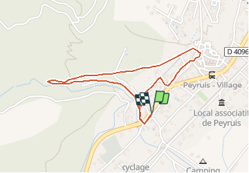
Tour Mountainbike von 2,1 km verfügbar auf Provence-Alpes-Côte d'Azur, Alpes-de-Haute-Provence, Peyruis. Diese Tour wird von tracegps vorgeschlagen.
Beschreibung
Circuit d'initiation, sans réelle difficulté, comportant quelques passages ludiques sur sentier. Il traverse le champ de Gau (petits jardinets en terrasse).
Ort
Land:
France
Region :
Provence-Alpes-Côte d'Azur
Abteilung/Provinz :
Alpes-de-Haute-Provence
Kommune :
Peyruis
Standort:
Unknown
Gehen Sie:(Dec)
Gehen Sie:(UTM)
735181 ; 4878808 (31T) N.
Kommentare
Touren in der Umgebung
![Tour Wandern Ganagobie - GANAGOBIE . Tour par le bas . Visite Ganagobie o m s - Photo](https://media.geolcdn.com/t/375/260/f43abf33-22fe-4846-8dac-9d35176e3e78.jpg&format=jpg&maxdim=2)
![Wandern Wandern](https://static1.geolcdn.com/sitytour/trail-icons/101.png)
GANAGOBIE . Tour par le bas . Visite Ganagobie o m s
Wandern
Medium
(1)
Ganagobie,
Provence-Alpes-Côte d'Azur,
Alpes-de-Haute-Provence,
France
![](/images/other/stat-length.png)
14,6 km | 21 km-effort
3h 55min
![](https://static1.geolcdn.com/siteimages/upload/files/16400158638029165_repeat_loop_refresh_sync_direction_icon.png)
Ja
![Tour Wandern Montfort - MONTFORT. Voie Royale . Chapelle saint Donat . Trou de l Hermite o .t - Photo](https://media.geolcdn.com/t/375/260/d6bdfeb5-13cc-49a1-ada4-32ae5dc71202.jpg&format=jpg&maxdim=2)
![Wandern Wandern](https://static1.geolcdn.com/sitytour/trail-icons/101.png)
MONTFORT. Voie Royale . Chapelle saint Donat . Trou de l Hermite o .t
Wandern
Medium
(1)
Montfort,
Provence-Alpes-Côte d'Azur,
Alpes-de-Haute-Provence,
France
![](/images/other/stat-length.png)
11,8 km | 15,3 km-effort
2h 59min
![](https://static1.geolcdn.com/siteimages/upload/files/16400158638029165_repeat_loop_refresh_sync_direction_icon.png)
Nein
![Tour Wandern Château-Arnoux-Saint-Auban - SAINT AUBAN . SENTIER DE DÉCOUVERTE DE L AÉRODROME O L - Photo](https://media.geolcdn.com/t/375/260/5308a4ad-7d11-40e8-b20c-9444363024fd.jpg&format=jpg&maxdim=2)
![Wandern Wandern](https://static1.geolcdn.com/sitytour/trail-icons/101.png)
SAINT AUBAN . SENTIER DE DÉCOUVERTE DE L AÉRODROME O L
Wandern
Medium
(1)
Château-Arnoux-Saint-Auban,
Provence-Alpes-Côte d'Azur,
Alpes-de-Haute-Provence,
France
![](/images/other/stat-length.png)
6,5 km | 7,6 km-effort
1h 40min
![](https://static1.geolcdn.com/siteimages/upload/files/16400158638029165_repeat_loop_refresh_sync_direction_icon.png)
Ja
![Tour Wandern Les Mées - Les Mées - Malijai - Les Mées - Photo](https://media.geolcdn.com/t/375/260/ext.jpg?maxdim=2&url=https%3A%2F%2Fservices.sitytrail.com%2FGeolivesWS%2FDownloadMedia.ashx%3FTrailID%3D107386%26Media%3D12288_6.jpg)
![Wandern Wandern](https://static1.geolcdn.com/sitytour/trail-icons/101.png)
Les Mées - Malijai - Les Mées
Wandern
Medium
(1)
Les Mées,
Provence-Alpes-Côte d'Azur,
Alpes-de-Haute-Provence,
France
![](/images/other/stat-length.png)
12,1 km | 18,1 km-effort
4h 30min
![](https://static1.geolcdn.com/siteimages/upload/files/16400158638029165_repeat_loop_refresh_sync_direction_icon.png)
Ja
![Tour Wandern Les Mées - Les Pénitents - circuit long - Les Mées - Photo](https://media.geolcdn.com/t/375/260/ext.jpg?maxdim=2&url=https%3A%2F%2Fservices.sitytrail.com%2FGeolivesWS%2FDownloadMedia.ashx%3FTrailID%3D107187%26Media%3D12039_6.jpg)
![Wandern Wandern](https://static1.geolcdn.com/sitytour/trail-icons/101.png)
Les Pénitents - circuit long - Les Mées
Wandern
Medium
(1)
Les Mées,
Provence-Alpes-Côte d'Azur,
Alpes-de-Haute-Provence,
France
![](/images/other/stat-length.png)
14,3 km | 21 km-effort
4h 0min
![](https://static1.geolcdn.com/siteimages/upload/files/16400158638029165_repeat_loop_refresh_sync_direction_icon.png)
Ja
![Tour Wandern Les Mées - Les Pénitents - circuit court - Les Mées - Photo](https://media.geolcdn.com/t/375/260/ext.jpg?maxdim=2&url=https%3A%2F%2Fservices.sitytrail.com%2FGeolivesWS%2FDownloadMedia.ashx%3FTrailID%3D107038%26Media%3D11843_5.jpg)
![Wandern Wandern](https://static1.geolcdn.com/sitytour/trail-icons/101.png)
Les Pénitents - circuit court - Les Mées
Wandern
Medium
(2)
Les Mées,
Provence-Alpes-Côte d'Azur,
Alpes-de-Haute-Provence,
France
![](/images/other/stat-length.png)
5,8 km | 9,5 km-effort
2h 0min
![](https://static1.geolcdn.com/siteimages/upload/files/16400158638029165_repeat_loop_refresh_sync_direction_icon.png)
Ja
![Tour Wandern Ganagobie - Plateau de Ganagobie - Photo](https://media.geolcdn.com/t/375/260/ext.jpg?maxdim=2&url=https%3A%2F%2Fservices.sitytrail.com%2FGeolivesWS%2FDownloadMedia.ashx%3FTrailID%3D107037%26Media%3D11842_5.jpg)
![Wandern Wandern](https://static1.geolcdn.com/sitytour/trail-icons/101.png)
Plateau de Ganagobie
Wandern
Medium
(2)
Ganagobie,
Provence-Alpes-Côte d'Azur,
Alpes-de-Haute-Provence,
France
![](/images/other/stat-length.png)
7,6 km | 10,9 km-effort
3h 0min
![](https://static1.geolcdn.com/siteimages/upload/files/16400158638029165_repeat_loop_refresh_sync_direction_icon.png)
Ja
![Tour Andere Aktivitäten Les Mées - MEES Penitents. San Peyre. Panneaux Volcanique. Saint Antoine - Photo](https://media.geolcdn.com/t/375/260/ext.jpg?maxdim=2&url=https%3A%2F%2Fstatic1.geolcdn.com%2Fsiteimages%2Fupload%2Ffiles%2F1545311037marcheuse_200dpi.jpg)
![Andere Aktivitäten Andere Aktivitäten](https://static1.geolcdn.com/sitytour/trail-icons/900.png)
MEES Penitents. San Peyre. Panneaux Volcanique. Saint Antoine
Andere Aktivitäten
Sehr leicht
(1)
Les Mées,
Provence-Alpes-Côte d'Azur,
Alpes-de-Haute-Provence,
France
![](/images/other/stat-length.png)
14,7 km | 22 km-effort
5h 47min
![](https://static1.geolcdn.com/siteimages/upload/files/16400158638029165_repeat_loop_refresh_sync_direction_icon.png)
Ja
![Tour Wandern Les Mées - 2023-04-14 Les Apollinaires- Haute montagne - Les Pénitents - Photo](https://media.geolcdn.com/t/375/260/f3a0c66a-8d90-4fe7-a5a0-7a5aeb543308.jpg&format=jpg&maxdim=2)
![Wandern Wandern](https://static1.geolcdn.com/sitytour/trail-icons/101.png)
2023-04-14 Les Apollinaires- Haute montagne - Les Pénitents
Wandern
Medium
Les Mées,
Provence-Alpes-Côte d'Azur,
Alpes-de-Haute-Provence,
France
![](/images/other/stat-length.png)
17,5 km | 26 km-effort
5h 49min
![](https://static1.geolcdn.com/siteimages/upload/files/16400158638029165_repeat_loop_refresh_sync_direction_icon.png)
Ja