![](/images/other/stat-length.png)
![Tour Wandern Lectoure - Lac des trois vallées - Lectoure - Photo](https://media.geolcdn.com/t/1900/400/ext.pjpeg?maxdim=2&url=https%3A%2F%2Fservices.sitytrail.com%2FGeolivesWS%2FDownloadMedia.ashx%3FTrailID%3D111907%26Media%3D8912_2.jpg)
Lac des trois vallées - Lectoure
tracegps
Benutzer
![Länge](/images/other/stat-length.png)
Länge
14,2 km
![Maximale Höhe](https://static1.geolcdn.com/siteimages/upload/files/1508320355ic_sort_altitude_max_24dp.png)
Maximale Höhe
193 m
![Positive Höhendifferenz](https://static1.geolcdn.com/siteimages/upload/files/1508320355ic_sort_den_pos_24dp.png)
Positive Höhendifferenz
306 m
![Km-Effort](/images/other/stat-length.png)
Km-Effort
18,3 km
![Min. Höhe](https://static1.geolcdn.com/siteimages/upload/files/1508320355ic_sort_altitude_min_24dp.png)
Min. Höhe
83 m
![Negative Höhendifferenz](https://static1.geolcdn.com/siteimages/upload/files/1508320355ic_sort_den_neg_24dp.png)
Negative Höhendifferenz
303 m
![Boucle](https://static1.geolcdn.com/siteimages/upload/files/16400158638029165_repeat_loop_refresh_sync_direction_icon.png)
Boucle
Ja
Erstellungsdatum :
2014-12-10 00:00:00.0
Letzte Änderung :
2014-12-10 00:00:00.0
![Wandern](https://static1.geolcdn.com/sitytour/trail-icons/101.png)
3h30
Schwierigkeit : Medium
![Scannen Sie diesen QR-Code, um die Tour in der SityTrail-Anwendung zu öffnen](https://capi.geolives.com/qq0zvz2zws4bq2lad0pu/sitytour/trails/111907/qr.png?size=200)
Kostenlosegpshiking-Anwendung
Über SityTrail
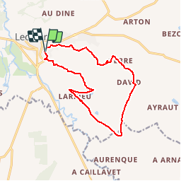
Tour Wandern von 14,2 km verfügbar auf Okzitanien, Gers, Lectoure. Diese Tour wird von tracegps vorgeschlagen.
Beschreibung
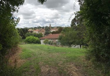
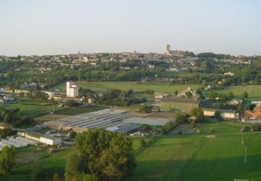
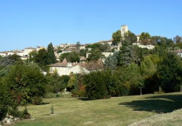
Lac des trois vallées - Lectoure Départ du Gymnase Maréchal Lannes. Intérêt : géomorphologie : découverte de la terre de Lomagne, calcaire, pierre blanche de taille et polyculture… Circuit numérisé par la Communauté de Communes de la Lomagne Gersoise.
Ort
Land:
France
Region :
Okzitanien
Abteilung/Provinz :
Gers
Kommune :
Lectoure
Standort:
Unknown
Gehen Sie:(Dec)
Gehen Sie:(UTM)
309582 ; 4866815 (31T) N.
Kommentare
Touren in der Umgebung
![Tour Wandern Lectoure - GR65 Lectoure > La Romieu - Photo](https://media.geolcdn.com/t/375/260/f56c4977-4bb0-4636-b10f-0a2a2329de52.jpg&format=jpg&maxdim=2)
![Wandern Wandern](https://static1.geolcdn.com/sitytour/trail-icons/101.png)
GR65 Lectoure > La Romieu
Wandern
Einfach
Lectoure,
Okzitanien,
Gers,
France
![](/images/other/stat-length.png)
18,8 km | 24 km-effort
5h 53min
![](https://static1.geolcdn.com/siteimages/upload/files/16400158638029165_repeat_loop_refresh_sync_direction_icon.png)
Nein
![Wandern Wandern](https://static1.geolcdn.com/sitytour/trail-icons/101.png)
CC_Velay_ED_20_Lectoure_Castelnau-Auvignon_20080820
Wandern
Medium
Lectoure,
Okzitanien,
Gers,
France
![](/images/other/stat-length.png)
24 km | 30 km-effort
5h 45min
![](https://static1.geolcdn.com/siteimages/upload/files/16400158638029165_repeat_loop_refresh_sync_direction_icon.png)
Nein
![Tour Wandern Lectoure - Lectoure - La Romieu - Chemin de Compostelle - Photo](https://media.geolcdn.com/t/375/260/ext.jpg?maxdim=2&url=https%3A%2F%2Fservices.sitytrail.com%2FGeolivesWS%2FDownloadMedia.ashx%3FTrailID%3D109610%26Media%3D4220_4.jpg)
![Wandern Wandern](https://static1.geolcdn.com/sitytour/trail-icons/101.png)
Lectoure - La Romieu - Chemin de Compostelle
Wandern
Sehr schwierig
Lectoure,
Okzitanien,
Gers,
France
![](/images/other/stat-length.png)
19,6 km | 24 km-effort
7h 10min
![](https://static1.geolcdn.com/siteimages/upload/files/16400158638029165_repeat_loop_refresh_sync_direction_icon.png)
Nein
![Tour Wandern Lectoure - 32-05-Au Cœur de Gascogne Auch-24km-102-5607- - Photo](https://media.geolcdn.com/t/375/260/eedc5c4f-5cf7-4106-9353-e66c52668c78.jpg&format=jpg&maxdim=2)
![Wandern Wandern](https://static1.geolcdn.com/sitytour/trail-icons/101.png)
32-05-Au Cœur de Gascogne Auch-24km-102-5607-
Wandern
Medium
Lectoure,
Okzitanien,
Gers,
France
![](/images/other/stat-length.png)
24 km | 29 km-effort
6h 10min
![](https://static1.geolcdn.com/siteimages/upload/files/16400158638029165_repeat_loop_refresh_sync_direction_icon.png)
Nein
![Tour Wandern Lectoure - espazot condom 13.7.2017 - Photo](https://media.geolcdn.com/t/375/260/ext.jpg?maxdim=2&url=https%3A%2F%2Fservices.sitytrail.com%2FGeolivesWS%2FDownloadMedia.ashx%3FTrailID%3D788942%26Media%3D20170713141850.jpg)
![Wandern Wandern](https://static1.geolcdn.com/sitytour/trail-icons/101.png)
espazot condom 13.7.2017
Wandern
Sehr leicht
Lectoure,
Okzitanien,
Gers,
France
![](/images/other/stat-length.png)
22 km | 27 km-effort
4h 50min
![](https://static1.geolcdn.com/siteimages/upload/files/16400158638029165_repeat_loop_refresh_sync_direction_icon.png)
Nein
![Tour Wandern Lectoure - Groussan - Lectoure - Photo](https://media.geolcdn.com/t/375/260/ext.jpg?maxdim=2&url=https%3A%2F%2Fservices.sitytrail.com%2FGeolivesWS%2FDownloadMedia.ashx%3FTrailID%3D111906%26Media%3D8911_2.jpg)
![Wandern Wandern](https://static1.geolcdn.com/sitytour/trail-icons/101.png)
Groussan - Lectoure
Wandern
Medium
Lectoure,
Okzitanien,
Gers,
France
![](/images/other/stat-length.png)
4 km | 5,8 km-effort
1h 0min
![](https://static1.geolcdn.com/siteimages/upload/files/16400158638029165_repeat_loop_refresh_sync_direction_icon.png)
Ja
![Tour Wandern Lectoure - Arton - Lectoure - Photo](https://media.geolcdn.com/t/375/260/ext.jpg?maxdim=2&url=https%3A%2F%2Fservices.sitytrail.com%2FGeolivesWS%2FDownloadMedia.ashx%3FTrailID%3D111785%26Media%3D8301_2.jpg)
![Wandern Wandern](https://static1.geolcdn.com/sitytour/trail-icons/101.png)
Arton - Lectoure
Wandern
Schwierig
Lectoure,
Okzitanien,
Gers,
France
![](/images/other/stat-length.png)
20 km | 25 km-effort
5h 0min
![](https://static1.geolcdn.com/siteimages/upload/files/16400158638029165_repeat_loop_refresh_sync_direction_icon.png)
Ja
![Tour Wandern Lectoure - Les Galis - Lectoure - Photo](https://media.geolcdn.com/t/375/260/ext.jpg?maxdim=2&url=https%3A%2F%2Fservices.sitytrail.com%2FGeolivesWS%2FDownloadMedia.ashx%3FTrailID%3D111784%26Media%3D8300_2.jpg)
![Wandern Wandern](https://static1.geolcdn.com/sitytour/trail-icons/101.png)
Les Galis - Lectoure
Wandern
Schwierig
Lectoure,
Okzitanien,
Gers,
France
![](/images/other/stat-length.png)
17,9 km | 23 km-effort
4h 30min
![](https://static1.geolcdn.com/siteimages/upload/files/16400158638029165_repeat_loop_refresh_sync_direction_icon.png)
Ja
![Tour Wandern Lectoure - Navère - Lectoure - Photo](https://media.geolcdn.com/t/375/260/ext.jpg?maxdim=2&url=https%3A%2F%2Fservices.sitytrail.com%2FGeolivesWS%2FDownloadMedia.ashx%3FTrailID%3D111783%26Media%3D8299_2.jpg)
![Wandern Wandern](https://static1.geolcdn.com/sitytour/trail-icons/101.png)
Navère - Lectoure
Wandern
Medium
Lectoure,
Okzitanien,
Gers,
France
![](/images/other/stat-length.png)
11,3 km | 14,9 km-effort
3h 0min
![](https://static1.geolcdn.com/siteimages/upload/files/16400158638029165_repeat_loop_refresh_sync_direction_icon.png)
Ja