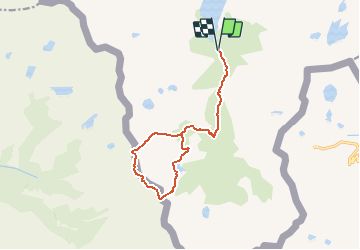
![](/images/other/stat-length.png)
![Tour Wandern Auzat - Le pic de la Rouge (Roumazet - la Soucarrane) - Photo](https://media.geolcdn.com/t/1900/400/ext.pjpeg?maxdim=2&url=https%3A%2F%2Fservices.sitytrail.com%2FGeolivesWS%2FDownloadMedia.ashx%3FTrailID%3D111887%26Media%3D8769_6.jpg)
Le pic de la Rouge (Roumazet - la Soucarrane)
tracegps
Benutzer
![Länge](/images/other/stat-length.png)
![Maximale Höhe](https://static1.geolcdn.com/siteimages/upload/files/1508320355ic_sort_altitude_max_24dp.png)
![Positive Höhendifferenz](https://static1.geolcdn.com/siteimages/upload/files/1508320355ic_sort_den_pos_24dp.png)
![Km-Effort](/images/other/stat-length.png)
![Min. Höhe](https://static1.geolcdn.com/siteimages/upload/files/1508320355ic_sort_altitude_min_24dp.png)
![Negative Höhendifferenz](https://static1.geolcdn.com/siteimages/upload/files/1508320355ic_sort_den_neg_24dp.png)
![Boucle](https://static1.geolcdn.com/siteimages/upload/files/16400158638029165_repeat_loop_refresh_sync_direction_icon.png)
![Wandern](https://static1.geolcdn.com/sitytour/trail-icons/101.png)
7h45
Schwierigkeit : Sehr schwierig
![Scannen Sie diesen QR-Code, um die Tour in der SityTrail-Anwendung zu öffnen](https://capi.geolives.com/qq0zvz2zws4bq2lad0pu/sitytour/trails/111887/qr.png?size=200)
Kostenlosegpshiking-Anwendung
Über SityTrail
Tour Wandern von 14,2 km verfügbar auf Okzitanien, Ariège, Auzat. Diese Tour wird von tracegps vorgeschlagen.
Beschreibung
Circuit proposé par l’Office de Tourisme de Tarascon & du Vicdessos. Départ : Dépassez Auzat, marc, le Pla de l’Isard, la route devient une piste carrossable. Garez-vous au parking des orris du Carla, juste après l’étang de Soulcem. Ce circuit au flanc Ouest de la vallée de Soulcem inclut notablement le circuit des Orris. Il devient dans un esprit plus sportif la randonnée des étangs de Roumazet et de la Soucarrane. C’est d’ailleurs aux seuls marcheurs expérimentés que le Pic de la Rouge, au sud du Canalbonne, est suggéré. Vous pouvez vous procurer le topoguide auprès de l’Office de Tourisme de Tarascon & du Vicdessos.
Ort
Kommentare
Touren in der Umgebung
![Tour Wandern Auzat - Le Picot - Photo](https://media.geolcdn.com/t/375/260/ext.jpg?maxdim=2&url=https%3A%2F%2Fservices.sitytrail.com%2FGeolivesWS%2FDownloadMedia.ashx%3FTrailID%3D218307%26Media%3D7d32352a-7ee3-4817-a78f-8417168ce812.JPG)
![Wandern Wandern](https://static1.geolcdn.com/sitytour/trail-icons/101.png)
Wandern
![](/images/other/stat-length.png)
![](https://static1.geolcdn.com/siteimages/upload/files/16400158638029165_repeat_loop_refresh_sync_direction_icon.png)
![Tour Wandern Auzat - Les étangs de la Gardelle - Auzat - Photo](https://media.geolcdn.com/t/375/260/ext.jpg?maxdim=2&url=https%3A%2F%2Fstatic1.geolcdn.com%2Fsiteimages%2Fupload%2Ffiles%2F1553511878bg_sport_marche.png)
![Wandern Wandern](https://static1.geolcdn.com/sitytour/trail-icons/101.png)
Wandern
![](/images/other/stat-length.png)
![](https://static1.geolcdn.com/siteimages/upload/files/16400158638029165_repeat_loop_refresh_sync_direction_icon.png)
![Wandern Wandern](https://static1.geolcdn.com/sitytour/trail-icons/101.png)
![Tour sport - Arcalis - Photo](https://media.geolcdn.com/t/375/260/04058f44-9f8f-463f-a1cc-559cb86b42ee.jpg&format=jpg&maxdim=2)
![Tour Wandern Auzat - Domaine de Montcalm -port Rat Pic Rouge - Photo](https://media.geolcdn.com/t/375/260/4ee9492f-31eb-4d1a-b77c-878ac1f5c4df.jpg&format=jpg&maxdim=2)
![Wandern Wandern](https://static1.geolcdn.com/sitytour/trail-icons/101.png)
Wandern
![](/images/other/stat-length.png)
![](https://static1.geolcdn.com/siteimages/upload/files/16400158638029165_repeat_loop_refresh_sync_direction_icon.png)
![Tour Wandern Auzat - Tour des lacs - Sarroucanes - Photo](https://media.geolcdn.com/t/375/260/45e48d9e-2f03-4378-bfe0-01a4ae1719c1.jpg&format=jpg&maxdim=2)
![Wandern Wandern](https://static1.geolcdn.com/sitytour/trail-icons/101.png)
Wandern
![](/images/other/stat-length.png)
![](https://static1.geolcdn.com/siteimages/upload/files/16400158638029165_repeat_loop_refresh_sync_direction_icon.png)
![Tour Wandern Auzat - Caraussans - Photo](https://media.geolcdn.com/t/375/260/13f3c7b9-396a-4438-ab57-e6debb7e127e.jpg&format=jpg&maxdim=2)
![Wandern Wandern](https://static1.geolcdn.com/sitytour/trail-icons/101.png)
Wandern
![](/images/other/stat-length.png)
![](https://static1.geolcdn.com/siteimages/upload/files/16400158638029165_repeat_loop_refresh_sync_direction_icon.png)
![Tour Wandern Auzat - Boucle etangs de la Gardelle - Photo](https://media.geolcdn.com/t/375/260/fb25dd7f-b9c3-45ab-85f7-b885de72aafa.jpg&format=jpg&maxdim=2)
![Wandern Wandern](https://static1.geolcdn.com/sitytour/trail-icons/101.png)
Wandern
![](/images/other/stat-length.png)
![](https://static1.geolcdn.com/siteimages/upload/files/16400158638029165_repeat_loop_refresh_sync_direction_icon.png)
![Tour Wandern Auzat - Fourcat - Photo](https://media.geolcdn.com/t/375/260/1246df19-c72a-49ce-9f67-6435cfda3815.jpg&format=jpg&maxdim=2)
![Wandern Wandern](https://static1.geolcdn.com/sitytour/trail-icons/101.png)
Wandern
![](/images/other/stat-length.png)
![](https://static1.geolcdn.com/siteimages/upload/files/16400158638029165_repeat_loop_refresh_sync_direction_icon.png)
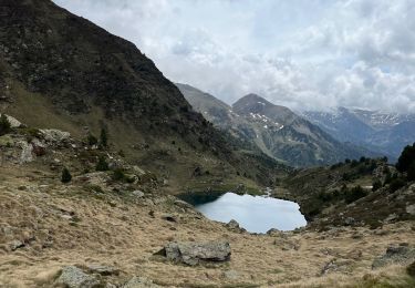
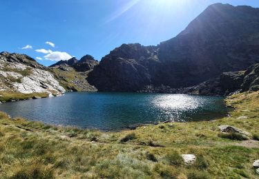
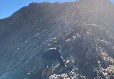
Très très beau sommet. Itinéraire à éviter pour ceux ayant le vertige.