![](/images/other/stat-length.png)
![Tour Wandern Clermont-de-Beauregard - Boucle de St Martin des Combes - Photo](https://media.geolcdn.com/t/1900/400/ext.pjpeg?maxdim=2&url=https%3A%2F%2Fservices.sitytrail.com%2FGeolivesWS%2FDownloadMedia.ashx%3FTrailID%3D1118074%26Media%3Dfix__20190303122636.jpg)
Boucle de St Martin des Combes
swp648
Benutzer
![Länge](/images/other/stat-length.png)
Länge
13,1 km
![Maximale Höhe](https://static1.geolcdn.com/siteimages/upload/files/1508320355ic_sort_altitude_max_24dp.png)
Maximale Höhe
193 m
![Positive Höhendifferenz](https://static1.geolcdn.com/siteimages/upload/files/1508320355ic_sort_den_pos_24dp.png)
Positive Höhendifferenz
210 m
![Km-Effort](/images/other/stat-length.png)
Km-Effort
15,9 km
![Min. Höhe](https://static1.geolcdn.com/siteimages/upload/files/1508320355ic_sort_altitude_min_24dp.png)
Min. Höhe
90 m
![Negative Höhendifferenz](https://static1.geolcdn.com/siteimages/upload/files/1508320355ic_sort_den_neg_24dp.png)
Negative Höhendifferenz
211 m
![Boucle](https://static1.geolcdn.com/siteimages/upload/files/16400158638029165_repeat_loop_refresh_sync_direction_icon.png)
Boucle
Ja
Erstellungsdatum :
2019-03-03 20:09:19.687
Letzte Änderung :
2019-03-03 20:09:19.687
![Wandern](https://static1.geolcdn.com/sitytour/trail-icons/101.png)
3h14
Schwierigkeit : Einfach
![Scannen Sie diesen QR-Code, um die Tour in der SityTrail-Anwendung zu öffnen](https://capi.geolives.com/qq0zvz2zws4bq2lad0pu/sitytour/trails/1118074/qr.png?size=200)
Kostenlosegpshiking-Anwendung
Über SityTrail
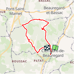
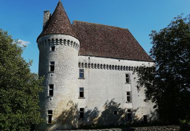
Tour Wandern von 13,1 km verfügbar auf Neu-Aquitanien, Dordogne, Clermont-de-Beauregard. Diese Tour wird von swp648 vorgeschlagen.
Beschreibung
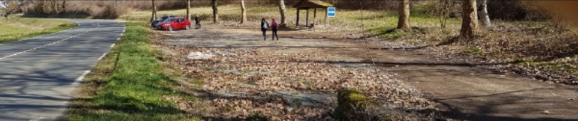
Départ du parking situé sur la D21, sur la gauche en direction de Bergerac au niveau de Clermont de Beauregard.
Ne pas tenir compte du balisage, suivre le tracé.
Ort
Land:
France
Region :
Neu-Aquitanien
Abteilung/Provinz :
Dordogne
Kommune :
Clermont-de-Beauregard
Standort:
Unknown
Gehen Sie:(Dec)
Gehen Sie:(UTM)
313584 ; 4980175 (31T) N.
Kommentare
Touren in der Umgebung
![Tour Zu Fuß Saint-Georges-de-Montclard - Boucle de Saint-Georges-de-Monclard - Photo](https://media.geolcdn.com/t/375/260/807de1be-4d48-4c71-ad3a-97ab304f6622.jpeg&format=jpg&maxdim=2)
![Zu Fuß Zu Fuß](https://static1.geolcdn.com/sitytour/trail-icons/100.png)
Boucle de Saint-Georges-de-Monclard
Zu Fuß
Einfach
Saint-Georges-de-Montclard,
Neu-Aquitanien,
Dordogne,
France
![](/images/other/stat-length.png)
5,8 km | 7,6 km-effort
1h 43min
![](https://static1.geolcdn.com/siteimages/upload/files/16400158638029165_repeat_loop_refresh_sync_direction_icon.png)
Nein
![Tour Wandern Fouleix - Fouleix - Photo](https://media.geolcdn.com/t/375/260/aa8e9b84-78fe-4825-ba6c-0363c55c9dee.jpg&format=jpg&maxdim=2)
![Wandern Wandern](https://static1.geolcdn.com/sitytour/trail-icons/101.png)
Fouleix
Wandern
Einfach
Fouleix,
Neu-Aquitanien,
Dordogne,
France
![](/images/other/stat-length.png)
9,4 km | 11,7 km-effort
2h 7min
![](https://static1.geolcdn.com/siteimages/upload/files/16400158638029165_repeat_loop_refresh_sync_direction_icon.png)
Ja
![Tour Wandern Fouleix - St Mayme de P. 20,2km - Photo](https://media.geolcdn.com/t/375/260/9e18d665-beb3-4bd8-afba-2d0a937195dd.jpg&format=jpg&maxdim=2)
![Wandern Wandern](https://static1.geolcdn.com/sitytour/trail-icons/101.png)
St Mayme de P. 20,2km
Wandern
Medium
Fouleix,
Neu-Aquitanien,
Dordogne,
France
![](/images/other/stat-length.png)
20 km | 25 km-effort
3h 41min
![](https://static1.geolcdn.com/siteimages/upload/files/16400158638029165_repeat_loop_refresh_sync_direction_icon.png)
Ja
![Tour Zu Fuß Saint-Félix-de-Villadeix - La Peyrouse - Photo](https://media.geolcdn.com/t/375/260/9cb9bfb4-bb69-4fc5-bf21-b699d679142d.jpeg&format=jpg&maxdim=2)
![Zu Fuß Zu Fuß](https://static1.geolcdn.com/sitytour/trail-icons/100.png)
La Peyrouse
Zu Fuß
Einfach
Saint-Félix-de-Villadeix,
Neu-Aquitanien,
Dordogne,
France
![](/images/other/stat-length.png)
14,6 km | 18,6 km-effort
4h 13min
![](https://static1.geolcdn.com/siteimages/upload/files/16400158638029165_repeat_loop_refresh_sync_direction_icon.png)
Ja
![Tour Wandern Beauregard-et-Bassac - Boucle des Fontaines 11,7km - Photo](https://media.geolcdn.com/t/375/260/ext.jpg?maxdim=2&url=https%3A%2F%2Fservices.sitytrail.com%2FGeolivesWS%2FDownloadMedia.ashx%3FTrailID%3D987121%26Media%3Dfix__20180615182458.jpg)
![Wandern Wandern](https://static1.geolcdn.com/sitytour/trail-icons/101.png)
Boucle des Fontaines 11,7km
Wandern
Einfach
Beauregard-et-Bassac,
Neu-Aquitanien,
Dordogne,
France
![](/images/other/stat-length.png)
11,7 km | 14,5 km-effort
3h 0min
![](https://static1.geolcdn.com/siteimages/upload/files/16400158638029165_repeat_loop_refresh_sync_direction_icon.png)
Ja
![Tour Wandern Beauregard-et-Bassac - randogps24-729 - Photo](https://media.geolcdn.com/t/375/260/ext.jpg?maxdim=2&url=https%3A%2F%2Fstatic1.geolcdn.com%2Fsiteimages%2Fupload%2Ffiles%2F1553511878bg_sport_marche.png)
![Wandern Wandern](https://static1.geolcdn.com/sitytour/trail-icons/101.png)
randogps24-729
Wandern
Medium
(1)
Beauregard-et-Bassac,
Neu-Aquitanien,
Dordogne,
France
![](/images/other/stat-length.png)
11,2 km | 14,2 km-effort
Unbekannt
![](https://static1.geolcdn.com/siteimages/upload/files/16400158638029165_repeat_loop_refresh_sync_direction_icon.png)
Ja
![Tour Wandern Beauregard-et-Bassac - Beauregard - Photo](https://media.geolcdn.com/t/375/260/ext.jpg?maxdim=2&url=https%3A%2F%2Fstatic1.geolcdn.com%2Fsiteimages%2Fupload%2Ffiles%2F1553511878bg_sport_marche.png)
![Wandern Wandern](https://static1.geolcdn.com/sitytour/trail-icons/101.png)
Beauregard
Wandern
Schwierig
Beauregard-et-Bassac,
Neu-Aquitanien,
Dordogne,
France
![](/images/other/stat-length.png)
11,6 km | 14,5 km-effort
2h 58min
![](https://static1.geolcdn.com/siteimages/upload/files/16400158638029165_repeat_loop_refresh_sync_direction_icon.png)
Ja
![Tour Mountainbike Saint-Martin-des-Combes - St Martin des Combes 40km - Photo](https://media.geolcdn.com/t/375/260/ext.jpg?maxdim=2&url=https%3A%2F%2Fstatic1.geolcdn.com%2Fsiteimages%2Fupload%2Ffiles%2F1524743154velo.jpg)
![Mountainbike Mountainbike](https://static1.geolcdn.com/sitytour/trail-icons/202.png)
St Martin des Combes 40km
Mountainbike
Medium
Saint-Martin-des-Combes,
Neu-Aquitanien,
Dordogne,
France
![](/images/other/stat-length.png)
40 km | 50 km-effort
3h 1min
![](https://static1.geolcdn.com/siteimages/upload/files/16400158638029165_repeat_loop_refresh_sync_direction_icon.png)
Ja
![Tour Wandern Saint-Félix-de-Villadeix - 20141129 - Saint Félix - Liorac - Photo](https://media.geolcdn.com/t/375/260/ext.jpg?maxdim=2&url=https%3A%2F%2Fstatic1.geolcdn.com%2Fsiteimages%2Fupload%2Ffiles%2F1553511878bg_sport_marche.png)
![Wandern Wandern](https://static1.geolcdn.com/sitytour/trail-icons/101.png)
20141129 - Saint Félix - Liorac
Wandern
Einfach
Saint-Félix-de-Villadeix,
Neu-Aquitanien,
Dordogne,
France
![](/images/other/stat-length.png)
17,3 km | 23 km-effort
3h 47min
![](https://static1.geolcdn.com/siteimages/upload/files/16400158638029165_repeat_loop_refresh_sync_direction_icon.png)
Ja