![](/images/other/stat-length.png)
![Tour Wandern Bréhal - Les Champagnes - St Martin Le Vieux - Photo](https://media.geolcdn.com/t/1900/400/ext.pjpeg?maxdim=2&url=https%3A%2F%2Fstatic1.geolcdn.com%2Fsiteimages%2Fupload%2Ffiles%2F1553511878bg_sport_marche.png)
Les Champagnes - St Martin Le Vieux
tracegps
Benutzer
![Länge](/images/other/stat-length.png)
Länge
4,5 km
![Maximale Höhe](https://static1.geolcdn.com/siteimages/upload/files/1508320355ic_sort_altitude_max_24dp.png)
Maximale Höhe
42 m
![Positive Höhendifferenz](https://static1.geolcdn.com/siteimages/upload/files/1508320355ic_sort_den_pos_24dp.png)
Positive Höhendifferenz
52 m
![Km-Effort](/images/other/stat-length.png)
Km-Effort
5,2 km
![Min. Höhe](https://static1.geolcdn.com/siteimages/upload/files/1508320355ic_sort_altitude_min_24dp.png)
Min. Höhe
4 m
![Negative Höhendifferenz](https://static1.geolcdn.com/siteimages/upload/files/1508320355ic_sort_den_neg_24dp.png)
Negative Höhendifferenz
56 m
![Boucle](https://static1.geolcdn.com/siteimages/upload/files/16400158638029165_repeat_loop_refresh_sync_direction_icon.png)
Boucle
Ja
Erstellungsdatum :
2014-12-10 00:00:00.0
Letzte Änderung :
2014-12-10 00:00:00.0
![Wandern](https://static1.geolcdn.com/sitytour/trail-icons/101.png)
1h00
Schwierigkeit : Einfach
![Scannen Sie diesen QR-Code, um die Tour in der SityTrail-Anwendung zu öffnen](https://capi.geolives.com/qq0zvz2zws4bq2lad0pu/sitytour/trails/111763/qr.png?size=200)
Kostenlosegpshiking-Anwendung
Über SityTrail
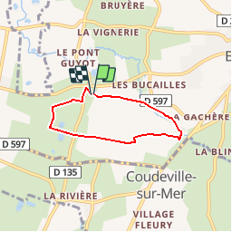
Tour Wandern von 4,5 km verfügbar auf Normandie, Manche, Bréhal. Diese Tour wird von tracegps vorgeschlagen.
Beschreibung
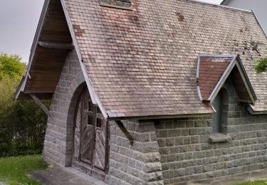
Promenade partant d'une belle église en ruine à St Martin le Vieux; quelques passages limites au printemps (de la boue jusqu'au moyeu de ma roue), passage le long de la Vanlée et d'une ancienne voie de chemin de fer.
Ort
Land:
France
Region :
Normandie
Abteilung/Provinz :
Manche
Kommune :
Bréhal
Standort:
Unknown
Gehen Sie:(Dec)
Gehen Sie:(UTM)
606964 ; 5416631 (30U) N.
Kommentare
Touren in der Umgebung
![Tour Mountainbike Donville-les-Bains - 50-vtt-donville-21km-200m - Photo](https://media.geolcdn.com/t/375/260/1780a610-d28f-4f7f-bdad-d32483604bd0.jpg&format=jpg&maxdim=2)
![Mountainbike Mountainbike](https://static1.geolcdn.com/sitytour/trail-icons/202.png)
50-vtt-donville-21km-200m
Mountainbike
Medium
Donville-les-Bains,
Normandie,
Manche,
France
![](/images/other/stat-length.png)
21 km | 24 km-effort
1h 39min
![](https://static1.geolcdn.com/siteimages/upload/files/16400158638029165_repeat_loop_refresh_sync_direction_icon.png)
Ja
![Tour Mountainbike Donville-les-Bains - 50-vtt-donville-28km - Photo](https://media.geolcdn.com/t/375/260/283ae410-e7da-45fb-9b33-aeccc3fd5afc.jpg&format=jpg&maxdim=2)
![Mountainbike Mountainbike](https://static1.geolcdn.com/sitytour/trail-icons/202.png)
50-vtt-donville-28km
Mountainbike
Medium
Donville-les-Bains,
Normandie,
Manche,
France
![](/images/other/stat-length.png)
28 km | 31 km-effort
2h 7min
![](https://static1.geolcdn.com/siteimages/upload/files/16400158638029165_repeat_loop_refresh_sync_direction_icon.png)
Ja
![Tour Wandern Donville-les-Bains - Donville Granville - Photo](https://media.geolcdn.com/t/375/260/ext.jpg?maxdim=2&url=https%3A%2F%2Fservices.sitytrail.com%2FGeolivesWS%2FDownloadMedia.ashx%3FTrailID%3D704938%26Media%3Dfix__20170225162805.jpg)
![Wandern Wandern](https://static1.geolcdn.com/sitytour/trail-icons/101.png)
Donville Granville
Wandern
Einfach
Donville-les-Bains,
Normandie,
Manche,
France
![](/images/other/stat-length.png)
5,8 km | 7,6 km-effort
1h 31min
![](https://static1.geolcdn.com/siteimages/upload/files/16400158638029165_repeat_loop_refresh_sync_direction_icon.png)
Nein
![Tour Wandern Donville-les-Bains - BALANCE SUR LES PLAGES DE BREVILLE - Photo](https://media.geolcdn.com/t/375/260/ext.jpg?maxdim=2&url=https%3A%2F%2Fservices.sitytrail.com%2FGeolivesWS%2FDownloadMedia.ashx%3FTrailID%3D415348%26Media%3D20150502112556.jpg)
![Wandern Wandern](https://static1.geolcdn.com/sitytour/trail-icons/101.png)
BALANCE SUR LES PLAGES DE BREVILLE
Wandern
Sehr leicht
Donville-les-Bains,
Normandie,
Manche,
France
![](/images/other/stat-length.png)
18,3 km | 19,6 km-effort
4h 40min
![](https://static1.geolcdn.com/siteimages/upload/files/16400158638029165_repeat_loop_refresh_sync_direction_icon.png)
Ja
![Tour Wandern Bréville-sur-Mer - Balade à Breville sur Mer - Photo](https://media.geolcdn.com/t/375/260/ext.jpg?maxdim=2&url=https%3A%2F%2Fservices.sitytrail.com%2FGeolivesWS%2FDownloadMedia.ashx%3FTrailID%3D172624%26Media%3D13990_6.jpg)
![Wandern Wandern](https://static1.geolcdn.com/sitytour/trail-icons/101.png)
Balade à Breville sur Mer
Wandern
Medium
Bréville-sur-Mer,
Normandie,
Manche,
France
![](/images/other/stat-length.png)
14,2 km | 15,4 km-effort
3h 0min
![](https://static1.geolcdn.com/siteimages/upload/files/16400158638029165_repeat_loop_refresh_sync_direction_icon.png)
Ja
![Tour Mountainbike Bréhal - brehal 1 - Photo](https://media.geolcdn.com/t/375/260/ext.jpg?maxdim=2&url=https%3A%2F%2Fservices.sitytrail.com%2FGeolivesWS%2FDownloadMedia.ashx%3FTrailID%3D141198%26Media%3D20120725112747.jpg)
![Mountainbike Mountainbike](https://static1.geolcdn.com/sitytour/trail-icons/202.png)
brehal 1
Mountainbike
Sehr leicht
Bréhal,
Normandie,
Manche,
France
![](/images/other/stat-length.png)
30 km | 35 km-effort
2h 45min
![](https://static1.geolcdn.com/siteimages/upload/files/16400158638029165_repeat_loop_refresh_sync_direction_icon.png)
Ja
![Tour Wandern Donville-les-Bains - BALADE À GRANDVILLE - Photo](https://media.geolcdn.com/t/375/260/ext.jpg?maxdim=2&url=https%3A%2F%2Fservices.sitytrail.com%2FGeolivesWS%2FDownloadMedia.ashx%3FTrailID%3D414676%26Media%3D20150501144440.jpg)
![Wandern Wandern](https://static1.geolcdn.com/sitytour/trail-icons/101.png)
BALADE À GRANDVILLE
Wandern
Einfach
Donville-les-Bains,
Normandie,
Manche,
France
![](/images/other/stat-length.png)
18,3 km | 22 km-effort
4h 58min
![](https://static1.geolcdn.com/siteimages/upload/files/16400158638029165_repeat_loop_refresh_sync_direction_icon.png)
Ja
![Tour Wandern Chanteloup - Le chant des Loups - Chanteloup - Photo](https://media.geolcdn.com/t/375/260/ext.jpg?maxdim=2&url=https%3A%2F%2Fservices.sitytrail.com%2FGeolivesWS%2FDownloadMedia.ashx%3FTrailID%3D111880%26Media%3D8727_2.jpg)
![Wandern Wandern](https://static1.geolcdn.com/sitytour/trail-icons/101.png)
Le chant des Loups - Chanteloup
Wandern
Medium
Chanteloup,
Normandie,
Manche,
France
![](/images/other/stat-length.png)
9 km | 10,4 km-effort
2h 0min
![](https://static1.geolcdn.com/siteimages/upload/files/16400158638029165_repeat_loop_refresh_sync_direction_icon.png)
Ja
![Tour Wandern Hudimesnil - Le Moulin du Pont - Hudimesnil - Photo](https://media.geolcdn.com/t/375/260/ext.jpg?maxdim=2&url=https%3A%2F%2Fservices.sitytrail.com%2FGeolivesWS%2FDownloadMedia.ashx%3FTrailID%3D111879%26Media%3D8726_1.jpg)
![Wandern Wandern](https://static1.geolcdn.com/sitytour/trail-icons/101.png)
Le Moulin du Pont - Hudimesnil
Wandern
Medium
(1)
Hudimesnil,
Normandie,
Manche,
France
![](/images/other/stat-length.png)
14,8 km | 17,3 km-effort
3h 30min
![](https://static1.geolcdn.com/siteimages/upload/files/16400158638029165_repeat_loop_refresh_sync_direction_icon.png)
Ja