![](/images/other/stat-length.png)
![Tour Wandern Mernel - Circuit du Bois de Courrouët - Mernel - Photo](https://media.geolcdn.com/t/1900/400/ext.pjpeg?maxdim=2&url=https%3A%2F%2Fstatic1.geolcdn.com%2Fsiteimages%2Fupload%2Ffiles%2F1553511878bg_sport_marche.png)
Circuit du Bois de Courrouët - Mernel
tracegps
Benutzer
![Länge](/images/other/stat-length.png)
Länge
11,1 km
![Maximale Höhe](https://static1.geolcdn.com/siteimages/upload/files/1508320355ic_sort_altitude_max_24dp.png)
Maximale Höhe
114 m
![Positive Höhendifferenz](https://static1.geolcdn.com/siteimages/upload/files/1508320355ic_sort_den_pos_24dp.png)
Positive Höhendifferenz
136 m
![Km-Effort](/images/other/stat-length.png)
Km-Effort
12,9 km
![Min. Höhe](https://static1.geolcdn.com/siteimages/upload/files/1508320355ic_sort_altitude_min_24dp.png)
Min. Höhe
64 m
![Negative Höhendifferenz](https://static1.geolcdn.com/siteimages/upload/files/1508320355ic_sort_den_neg_24dp.png)
Negative Höhendifferenz
137 m
![Boucle](https://static1.geolcdn.com/siteimages/upload/files/16400158638029165_repeat_loop_refresh_sync_direction_icon.png)
Boucle
Ja
Erstellungsdatum :
2014-12-10 00:00:00.0
Letzte Änderung :
2014-12-10 00:00:00.0
![Wandern](https://static1.geolcdn.com/sitytour/trail-icons/101.png)
2h45
Schwierigkeit : Medium
![Scannen Sie diesen QR-Code, um die Tour in der SityTrail-Anwendung zu öffnen](https://capi.geolives.com/qq0zvz2zws4bq2lad0pu/sitytour/trails/111749/qr.png?size=200)
Kostenlosegpshiking-Anwendung
Über SityTrail
Tour Wandern von 11,1 km verfügbar auf Bretagne, Ille-et-Vilaine, Mernel. Diese Tour wird von tracegps vorgeschlagen.
Beschreibung
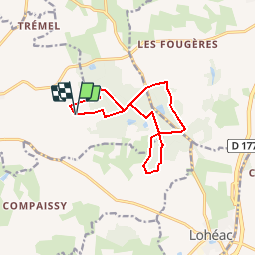
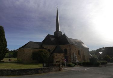
Circuit proposé par la maison du tourisme du Pays de Redon . Départ du parking du moto-cross au bois de Boutin, à Mernel. Retrouvez le plan du circuit et son descriptif sur le site du Pays de Redon.
Ort
Land:
France
Region :
Bretagne
Abteilung/Provinz :
Ille-et-Vilaine
Kommune :
Mernel
Standort:
Unknown
Gehen Sie:(Dec)
Gehen Sie:(UTM)
579823 ; 5305112 (30T) N.
Kommentare
Touren in der Umgebung
![Tour Zu Fuß La Chapelle-Bouëxic - Le Chêne au Loup - Photo](https://media.geolcdn.com/t/375/260/501712a5-28cb-46f2-a45e-d3567afacf90.jpeg&format=jpg&maxdim=2)
![Zu Fuß Zu Fuß](https://static1.geolcdn.com/sitytour/trail-icons/100.png)
Le Chêne au Loup
Zu Fuß
Einfach
La Chapelle-Bouëxic,
Bretagne,
Ille-et-Vilaine,
France
![](/images/other/stat-length.png)
15,2 km | 17,9 km-effort
4h 4min
![](https://static1.geolcdn.com/siteimages/upload/files/16400158638029165_repeat_loop_refresh_sync_direction_icon.png)
Ja
![Tour Fahrrad Lohéac - Circuit de Lohéac n°7 - Photo](https://media.geolcdn.com/t/375/260/ext.jpg?maxdim=2&url=https%3A%2F%2Fservices.sitytrail.com%2FGeolivesWS%2FDownloadMedia.ashx%3FTrailID%3D317624%26Media%3D16891_5.jpg)
![Fahrrad Fahrrad](https://static1.geolcdn.com/sitytour/trail-icons/200.png)
Circuit de Lohéac n°7
Fahrrad
Schwierig
Lohéac,
Bretagne,
Ille-et-Vilaine,
France
![](/images/other/stat-length.png)
34 km | 38 km-effort
3h 15min
![](https://static1.geolcdn.com/siteimages/upload/files/16400158638029165_repeat_loop_refresh_sync_direction_icon.png)
Ja
![Tour Fahrrad Val d'Anast - Circuit vélo de Maure de Bretagne - Photo](https://media.geolcdn.com/t/375/260/ext.jpg?maxdim=2&url=https%3A%2F%2Fservices.sitytrail.com%2FGeolivesWS%2FDownloadMedia.ashx%3FTrailID%3D111824%26Media%3D8470_3.jpg)
![Fahrrad Fahrrad](https://static1.geolcdn.com/sitytour/trail-icons/200.png)
Circuit vélo de Maure de Bretagne
Fahrrad
Medium
Val d'Anast,
Bretagne,
Ille-et-Vilaine,
France
![](/images/other/stat-length.png)
36 km | 42 km-effort
2h 0min
![](https://static1.geolcdn.com/siteimages/upload/files/16400158638029165_repeat_loop_refresh_sync_direction_icon.png)
Ja
![Tour Fahrrad Lohéac - Circuit vélo de Lohéac - Photo](https://media.geolcdn.com/t/375/260/ext.jpg?maxdim=2&url=https%3A%2F%2Fservices.sitytrail.com%2FGeolivesWS%2FDownloadMedia.ashx%3FTrailID%3D111823%26Media%3D8467_5.jpg)
![Fahrrad Fahrrad](https://static1.geolcdn.com/sitytour/trail-icons/200.png)
Circuit vélo de Lohéac
Fahrrad
Medium
Lohéac,
Bretagne,
Ille-et-Vilaine,
France
![](/images/other/stat-length.png)
34 km | 38 km-effort
1h 45min
![](https://static1.geolcdn.com/siteimages/upload/files/16400158638029165_repeat_loop_refresh_sync_direction_icon.png)
Ja
![Tour Wandern La Chapelle-Bouëxic - 07052021 la Chapelle bouexic - Photo](https://media.geolcdn.com/t/375/260/e829a918-0411-4ac7-a4f4-ba1e365a3189.jpg&format=jpg&maxdim=2)
![Wandern Wandern](https://static1.geolcdn.com/sitytour/trail-icons/101.png)
07052021 la Chapelle bouexic
Wandern
Einfach
La Chapelle-Bouëxic,
Bretagne,
Ille-et-Vilaine,
France
![](/images/other/stat-length.png)
23 km | 27 km-effort
5h 26min
![](https://static1.geolcdn.com/siteimages/upload/files/16400158638029165_repeat_loop_refresh_sync_direction_icon.png)
Ja
![Tour Wandern Mernel - MERNEL / BOIS DE COURROUET 13 01 2019 - Photo](https://media.geolcdn.com/t/375/260/ext.jpg?maxdim=2&url=https%3A%2F%2Fservices.sitytrail.com%2FGeolivesWS%2FDownloadMedia.ashx%3FTrailID%3D1096545%26Media%3Dfix__20190113105440.jpg)
![Wandern Wandern](https://static1.geolcdn.com/sitytour/trail-icons/101.png)
MERNEL / BOIS DE COURROUET 13 01 2019
Wandern
Sehr leicht
Mernel,
Bretagne,
Ille-et-Vilaine,
France
![](/images/other/stat-length.png)
11,2 km | 13 km-effort
2h 56min
![](https://static1.geolcdn.com/siteimages/upload/files/16400158638029165_repeat_loop_refresh_sync_direction_icon.png)
Ja
![Tour Wandern Guipry-Messac - 02.02.2018 - Chaumeray et Phily - Photo](https://media.geolcdn.com/t/375/260/ext.jpg?maxdim=2&url=https%3A%2F%2Fservices.sitytrail.com%2FGeolivesWS%2FDownloadMedia.ashx%3FTrailID%3D898898%26Media%3D20180202145939.jpg)
![Wandern Wandern](https://static1.geolcdn.com/sitytour/trail-icons/101.png)
02.02.2018 - Chaumeray et Phily
Wandern
Medium
Guipry-Messac,
Bretagne,
Ille-et-Vilaine,
France
![](/images/other/stat-length.png)
28 km | 34 km-effort
6h 58min
![](https://static1.geolcdn.com/siteimages/upload/files/16400158638029165_repeat_loop_refresh_sync_direction_icon.png)
Ja
![Tour Wandern Guipry-Messac - 02.02.2018 - Chaumeray et Phily - Photo](https://media.geolcdn.com/t/375/260/ext.jpg?maxdim=2&url=https%3A%2F%2Fservices.sitytrail.com%2FGeolivesWS%2FDownloadMedia.ashx%3FTrailID%3D898069%26Media%3D20180202145939.jpg)
![Wandern Wandern](https://static1.geolcdn.com/sitytour/trail-icons/101.png)
02.02.2018 - Chaumeray et Phily
Wandern
Medium
Guipry-Messac,
Bretagne,
Ille-et-Vilaine,
France
![](/images/other/stat-length.png)
28 km | 34 km-effort
6h 58min
![](https://static1.geolcdn.com/siteimages/upload/files/16400158638029165_repeat_loop_refresh_sync_direction_icon.png)
Ja
![Tour Hybrid-Bike La Chapelle-Bouëxic - lcb guipry guer - Photo](https://media.geolcdn.com/t/375/260/ext.jpg?maxdim=2&url=https%3A%2F%2Fstatic1.geolcdn.com%2Fsiteimages%2Fupload%2Ffiles%2F1524743154velo.jpg)
![Hybrid-Bike Hybrid-Bike](https://static1.geolcdn.com/sitytour/trail-icons/203.png)
lcb guipry guer
Hybrid-Bike
Medium
La Chapelle-Bouëxic,
Bretagne,
Ille-et-Vilaine,
France
![](/images/other/stat-length.png)
56 km | 63 km-effort
3h 13min
![](https://static1.geolcdn.com/siteimages/upload/files/16400158638029165_repeat_loop_refresh_sync_direction_icon.png)
Ja