![](/images/other/stat-length.png)
![Tour Wandern Vindelle - Circuit de Vindelle - Photo](https://media.geolcdn.com/t/1900/400/ext.pjpeg?maxdim=2&url=https%3A%2F%2Fstatic1.geolcdn.com%2Fsiteimages%2Fupload%2Ffiles%2F1553511878bg_sport_marche.png)
Circuit de Vindelle
tracegps
Benutzer
![Länge](/images/other/stat-length.png)
Länge
9,3 km
![Maximale Höhe](https://static1.geolcdn.com/siteimages/upload/files/1508320355ic_sort_altitude_max_24dp.png)
Maximale Höhe
116 m
![Positive Höhendifferenz](https://static1.geolcdn.com/siteimages/upload/files/1508320355ic_sort_den_pos_24dp.png)
Positive Höhendifferenz
176 m
![Km-Effort](/images/other/stat-length.png)
Km-Effort
11,6 km
![Min. Höhe](https://static1.geolcdn.com/siteimages/upload/files/1508320355ic_sort_altitude_min_24dp.png)
Min. Höhe
38 m
![Negative Höhendifferenz](https://static1.geolcdn.com/siteimages/upload/files/1508320355ic_sort_den_neg_24dp.png)
Negative Höhendifferenz
170 m
![Boucle](https://static1.geolcdn.com/siteimages/upload/files/16400158638029165_repeat_loop_refresh_sync_direction_icon.png)
Boucle
Ja
Erstellungsdatum :
2014-12-10 00:00:00.0
Letzte Änderung :
2014-12-10 00:00:00.0
![Wandern](https://static1.geolcdn.com/sitytour/trail-icons/101.png)
2h19
Schwierigkeit : Medium
![Scannen Sie diesen QR-Code, um die Tour in der SityTrail-Anwendung zu öffnen](https://capi.geolives.com/qq0zvz2zws4bq2lad0pu/sitytour/trails/111730/qr.png?size=200)
Kostenlosegpshiking-Anwendung
Über SityTrail
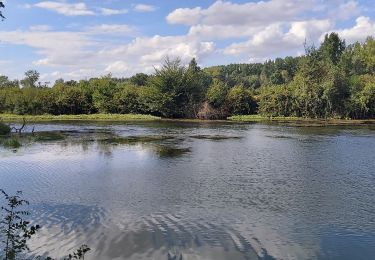
Tour Wandern von 9,3 km verfügbar auf Neu-Aquitanien, Charente, Vindelle. Diese Tour wird von tracegps vorgeschlagen.
Beschreibung
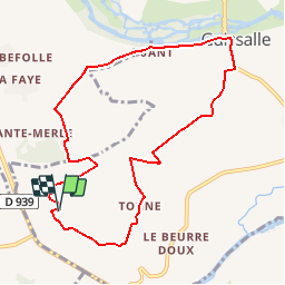
Circuit proposé par la communauté de communes Braconne et Charente et le Pays d’Entre Touvre & Charente. Départ du hameau de Tonne à Vindelle. Retrouvez le circuit sur le site de la communauté de communes Braconne et Charente.
Ort
Land:
France
Region :
Neu-Aquitanien
Abteilung/Provinz :
Charente
Kommune :
Vindelle
Standort:
Unknown
Gehen Sie:(Dec)
Gehen Sie:(UTM)
272844 ; 5066340 (31T) N.
Kommentare
Touren in der Umgebung
![Tour Wandern Saint-Saturnin - La balade de TARSAC 16290 CHARENTE - Photo](https://media.geolcdn.com/t/375/260/7183e879-9a00-4a1b-980e-566ec0af9abd.jpg&format=jpg&maxdim=2)
![Wandern Wandern](https://static1.geolcdn.com/sitytour/trail-icons/101.png)
La balade de TARSAC 16290 CHARENTE
Wandern
Sehr leicht
Saint-Saturnin,
Neu-Aquitanien,
Charente,
France
![](/images/other/stat-length.png)
7,1 km | 8,9 km-effort
2h 28min
![](https://static1.geolcdn.com/siteimages/upload/files/16400158638029165_repeat_loop_refresh_sync_direction_icon.png)
Ja
![Tour Wandern Marsac - Le circuit de la fontaine de Tonne - Photo](https://media.geolcdn.com/t/375/260/ext.jpg?maxdim=2&url=https%3A%2F%2Fservices.sitytrail.com%2FGeolivesWS%2FDownloadMedia.ashx%3FTrailID%3D957177%26Media%3Dfix__20180503164641.jpg)
![Wandern Wandern](https://static1.geolcdn.com/sitytour/trail-icons/101.png)
Le circuit de la fontaine de Tonne
Wandern
Einfach
Marsac,
Neu-Aquitanien,
Charente,
France
![](/images/other/stat-length.png)
9,2 km | 11,6 km-effort
2h 36min
![](https://static1.geolcdn.com/siteimages/upload/files/16400158638029165_repeat_loop_refresh_sync_direction_icon.png)
Ja
![Tour Wandern Asnières-sur-Nouère - Asniéres sur NOUERE charente - Photo](https://media.geolcdn.com/t/375/260/ext.jpg?maxdim=2&url=https%3A%2F%2Fservices.sitytrail.com%2FGeolivesWS%2FDownloadMedia.ashx%3FTrailID%3D870011%26Media%3Dfix__20171130162704.jpg)
![Wandern Wandern](https://static1.geolcdn.com/sitytour/trail-icons/101.png)
Asniéres sur NOUERE charente
Wandern
Einfach
(1)
Asnières-sur-Nouère,
Neu-Aquitanien,
Charente,
France
![](/images/other/stat-length.png)
9,3 km | 11,4 km-effort
2h 37min
![](https://static1.geolcdn.com/siteimages/upload/files/16400158638029165_repeat_loop_refresh_sync_direction_icon.png)
Ja
![Tour Wandern Vindelle - vindelle - Photo](https://media.geolcdn.com/t/375/260/22e36fba-4c2f-40ed-9fac-69b36387995a.jpg&format=jpg&maxdim=2)
![Wandern Wandern](https://static1.geolcdn.com/sitytour/trail-icons/101.png)
vindelle
Wandern
Medium
Vindelle,
Neu-Aquitanien,
Charente,
France
![](/images/other/stat-length.png)
10,5 km | 11,7 km-effort
2h 27min
![](https://static1.geolcdn.com/siteimages/upload/files/16400158638029165_repeat_loop_refresh_sync_direction_icon.png)
Ja
![Tour Nordic Walking Saint-Yrieix-sur-Charente - fleac boucle2 - Photo](https://media.geolcdn.com/t/375/260/ext.jpg?maxdim=2&url=https%3A%2F%2Fstatic1.geolcdn.com%2Fsiteimages%2Fupload%2Ffiles%2F1545311037marcheuse_200dpi.jpg)
![Nordic Walking Nordic Walking](https://static1.geolcdn.com/sitytour/trail-icons/102.png)
fleac boucle2
Nordic Walking
Sehr leicht
Saint-Yrieix-sur-Charente,
Neu-Aquitanien,
Charente,
France
![](/images/other/stat-length.png)
5,7 km | 6,5 km-effort
1h 10min
![](https://static1.geolcdn.com/siteimages/upload/files/16400158638029165_repeat_loop_refresh_sync_direction_icon.png)
Ja
![Tour Nordic Walking Saint-Yrieix-sur-Charente - fleac 8 - Photo](https://media.geolcdn.com/t/375/260/ext.jpg?maxdim=2&url=https%3A%2F%2Fstatic1.geolcdn.com%2Fsiteimages%2Fupload%2Ffiles%2F1545311037marcheuse_200dpi.jpg)
![Nordic Walking Nordic Walking](https://static1.geolcdn.com/sitytour/trail-icons/102.png)
fleac 8
Nordic Walking
Einfach
Saint-Yrieix-sur-Charente,
Neu-Aquitanien,
Charente,
France
![](/images/other/stat-length.png)
8,3 km | 10,2 km-effort
1h 50min
![](https://static1.geolcdn.com/siteimages/upload/files/16400158638029165_repeat_loop_refresh_sync_direction_icon.png)
Ja
![Tour Wandern Saint-Yrieix-sur-Charente - chauuseloup/Fleac - Photo](https://media.geolcdn.com/t/375/260/ext.jpg?maxdim=2&url=https%3A%2F%2Fstatic1.geolcdn.com%2Fsiteimages%2Fupload%2Ffiles%2F1553511878bg_sport_marche.png)
![Wandern Wandern](https://static1.geolcdn.com/sitytour/trail-icons/101.png)
chauuseloup/Fleac
Wandern
Sehr leicht
Saint-Yrieix-sur-Charente,
Neu-Aquitanien,
Charente,
France
![](/images/other/stat-length.png)
8,1 km | 9,6 km-effort
2h 0min
![](https://static1.geolcdn.com/siteimages/upload/files/16400158638029165_repeat_loop_refresh_sync_direction_icon.png)
Ja
![Tour Nordic Walking Saint-Yrieix-sur-Charente - guinguette1 - Photo](https://media.geolcdn.com/t/375/260/ext.jpg?maxdim=2&url=https%3A%2F%2Fstatic1.geolcdn.com%2Fsiteimages%2Fupload%2Ffiles%2F1545311037marcheuse_200dpi.jpg)
![Nordic Walking Nordic Walking](https://static1.geolcdn.com/sitytour/trail-icons/102.png)
guinguette1
Nordic Walking
Sehr leicht
Saint-Yrieix-sur-Charente,
Neu-Aquitanien,
Charente,
France
![](/images/other/stat-length.png)
6,7 km | 7,3 km-effort
1h 23min
![](https://static1.geolcdn.com/siteimages/upload/files/16400158638029165_repeat_loop_refresh_sync_direction_icon.png)
Ja
![Tour Nordic Walking Saint-Yrieix-sur-Charente - flac 4 - Photo](https://media.geolcdn.com/t/375/260/ext.jpg?maxdim=2&url=https%3A%2F%2Fstatic1.geolcdn.com%2Fsiteimages%2Fupload%2Ffiles%2F1545311037marcheuse_200dpi.jpg)
![Nordic Walking Nordic Walking](https://static1.geolcdn.com/sitytour/trail-icons/102.png)
flac 4
Nordic Walking
Sehr leicht
Saint-Yrieix-sur-Charente,
Neu-Aquitanien,
Charente,
France
![](/images/other/stat-length.png)
5,4 km | 6,4 km-effort
1h 3min
![](https://static1.geolcdn.com/siteimages/upload/files/16400158638029165_repeat_loop_refresh_sync_direction_icon.png)
Ja