![](/images/other/stat-length.png)
![Tour Wandern Guipry-Messac - Rochers de Corbiniéres - Messac Guipry - Photo](https://media.geolcdn.com/t/1900/400/ext.pjpeg?maxdim=2&url=https%3A%2F%2Fservices.sitytrail.com%2FGeolivesWS%2FDownloadMedia.ashx%3FTrailID%3D111684%26Media%3D7934_6.jpg)
Rochers de Corbiniéres - Messac Guipry
tracegps
Benutzer
![Länge](/images/other/stat-length.png)
Länge
13,9 km
![Maximale Höhe](https://static1.geolcdn.com/siteimages/upload/files/1508320355ic_sort_altitude_max_24dp.png)
Maximale Höhe
101 m
![Positive Höhendifferenz](https://static1.geolcdn.com/siteimages/upload/files/1508320355ic_sort_den_pos_24dp.png)
Positive Höhendifferenz
249 m
![Km-Effort](/images/other/stat-length.png)
Km-Effort
17,2 km
![Min. Höhe](https://static1.geolcdn.com/siteimages/upload/files/1508320355ic_sort_altitude_min_24dp.png)
Min. Höhe
4 m
![Negative Höhendifferenz](https://static1.geolcdn.com/siteimages/upload/files/1508320355ic_sort_den_neg_24dp.png)
Negative Höhendifferenz
249 m
![Boucle](https://static1.geolcdn.com/siteimages/upload/files/16400158638029165_repeat_loop_refresh_sync_direction_icon.png)
Boucle
Ja
Erstellungsdatum :
2014-12-10 00:00:00.0
Letzte Änderung :
2014-12-10 00:00:00.0
![Wandern](https://static1.geolcdn.com/sitytour/trail-icons/101.png)
3h45
Schwierigkeit : Schwierig
![Scannen Sie diesen QR-Code, um die Tour in der SityTrail-Anwendung zu öffnen](https://capi.geolives.com/qq0zvz2zws4bq2lad0pu/sitytour/trails/111684/qr.png?size=200)
Kostenlosegpshiking-Anwendung
Über SityTrail
Tour Wandern von 13,9 km verfügbar auf Bretagne, Ille-et-Vilaine, Guipry-Messac. Diese Tour wird von tracegps vorgeschlagen.
Beschreibung
Circuit proposé par la maison du tourisme du Pays de Redon. Départ de l’auberge de baron. Retrouvez le circuit sur le site du Pays de Redon.
Ort
Land:
France
Region :
Bretagne
Abteilung/Provinz :
Ille-et-Vilaine
Kommune :
Guipry-Messac
Standort:
Guipry
Gehen Sie:(Dec)
Gehen Sie:(UTM)
585885 ; 5292703 (30T) N.
Kommentare
Touren in der Umgebung
![Tour Pferd Langon - Vallées, landes et mégalithes entre Langon et Cournon - Photo](https://media.geolcdn.com/t/375/260/ext.jpg?maxdim=2&url=https%3A%2F%2Fservices.sitytrail.com%2FGeolivesWS%2FDownloadMedia.ashx%3FTrailID%3D317577%26Media%3D16836_5.jpg)
![Pferd Pferd](https://static1.geolcdn.com/sitytour/trail-icons/300.png)
Vallées, landes et mégalithes entre Langon et Cournon
Pferd
Schwierig
Langon,
Bretagne,
Ille-et-Vilaine,
France
![](/images/other/stat-length.png)
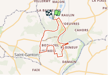
33 km | 39 km-effort
3h 0min
![](https://static1.geolcdn.com/siteimages/upload/files/16400158638029165_repeat_loop_refresh_sync_direction_icon.png)
Nein
![Tour Pferd Guipry-Messac - Chevauchée au coeur de la vallée de la Vilaine - Guipry - Photo](https://media.geolcdn.com/t/375/260/ext.jpg?maxdim=2&url=https%3A%2F%2Fservices.sitytrail.com%2FGeolivesWS%2FDownloadMedia.ashx%3FTrailID%3D317252%26Media%3D16434_5.jpg)
![Pferd Pferd](https://static1.geolcdn.com/sitytour/trail-icons/300.png)
Chevauchée au coeur de la vallée de la Vilaine - Guipry
Pferd
Schwierig
Guipry-Messac,
Bretagne,
Ille-et-Vilaine,
France
![](/images/other/stat-length.png)
29 km | 36 km-effort
4h 0min
![](https://static1.geolcdn.com/siteimages/upload/files/16400158638029165_repeat_loop_refresh_sync_direction_icon.png)
Ja
![Tour Wandern Langon - Circuit à l'Assaut de Corbinières - Langon - Photo](https://media.geolcdn.com/t/375/260/ext.jpg?maxdim=2&url=https%3A%2F%2Fservices.sitytrail.com%2FGeolivesWS%2FDownloadMedia.ashx%3FTrailID%3D111779%26Media%3D8286_5.jpg)
![Wandern Wandern](https://static1.geolcdn.com/sitytour/trail-icons/101.png)
Circuit à l'Assaut de Corbinières - Langon
Wandern
Schwierig
Langon,
Bretagne,
Ille-et-Vilaine,
France
![](/images/other/stat-length.png)
15,6 km | 19,8 km-effort
4h 0min
![](https://static1.geolcdn.com/siteimages/upload/files/16400158638029165_repeat_loop_refresh_sync_direction_icon.png)
Ja
![Tour Wandern Guipry-Messac - L'étang et le bois de Baron - Messac Guipry - Photo](https://media.geolcdn.com/t/375/260/ext.jpg?maxdim=2&url=https%3A%2F%2Fservices.sitytrail.com%2FGeolivesWS%2FDownloadMedia.ashx%3FTrailID%3D111683%26Media%3D7933_2.jpg)
![Wandern Wandern](https://static1.geolcdn.com/sitytour/trail-icons/101.png)
L'étang et le bois de Baron - Messac Guipry
Wandern
Medium
Guipry-Messac,
Bretagne,
Ille-et-Vilaine,
France
![](/images/other/stat-length.png)
8,5 km | 10,9 km-effort
2h 10min
![](https://static1.geolcdn.com/siteimages/upload/files/16400158638029165_repeat_loop_refresh_sync_direction_icon.png)
Ja
![Tour Elektrofahrrad Guipry-Messac - Guipry-Messac à Redon - Photo](https://media.geolcdn.com/t/375/260/ext.jpg?maxdim=2&url=https%3A%2F%2Fstatic1.geolcdn.com%2Fsiteimages%2Fupload%2Ffiles%2F1524743154velo.jpg)
![Elektrofahrrad Elektrofahrrad](https://static1.geolcdn.com/sitytour/trail-icons/205.png)
Guipry-Messac à Redon
Elektrofahrrad
Medium
Guipry-Messac,
Bretagne,
Ille-et-Vilaine,
France
![](/images/other/stat-length.png)
46 km | 50 km-effort
3h 33min
![](https://static1.geolcdn.com/siteimages/upload/files/16400158638029165_repeat_loop_refresh_sync_direction_icon.png)
Nein
![Tour Wandern Guipry-Messac - vous de baron - Photo](https://media.geolcdn.com/t/375/260/1e029175-1328-4018-9b31-3921eccd22c8.jpg&format=jpg&maxdim=2)
![Wandern Wandern](https://static1.geolcdn.com/sitytour/trail-icons/101.png)
vous de baron
Wandern
Einfach
Guipry-Messac,
Bretagne,
Ille-et-Vilaine,
France
![](/images/other/stat-length.png)
9,4 km | 11,8 km-effort
2h 6min
![](https://static1.geolcdn.com/siteimages/upload/files/16400158638029165_repeat_loop_refresh_sync_direction_icon.png)
Ja
![Tour Wandern Guipry-Messac - 14/07/2024 - Étang Baron à Corbinières - Photo](https://media.geolcdn.com/t/375/260/ext.jpg?maxdim=2&url=https%3A%2F%2Fstatic1.geolcdn.com%2Fsiteimages%2Fupload%2Ffiles%2F1553511878bg_sport_marche.png)
![Wandern Wandern](https://static1.geolcdn.com/sitytour/trail-icons/101.png)
14/07/2024 - Étang Baron à Corbinières
Wandern
Medium
Guipry-Messac,
Bretagne,
Ille-et-Vilaine,
France
![](/images/other/stat-length.png)
9 km | 11,5 km-effort
2h 34min
![](https://static1.geolcdn.com/siteimages/upload/files/16400158638029165_repeat_loop_refresh_sync_direction_icon.png)
Ja
![Tour Radtourismus Guipry-Messac - [BRETAGNE 2024] ET 4 - De Guipry à Saint-Nicolas de Redon - Photo](https://media.geolcdn.com/t/375/260/ext.jpg?maxdim=2&url=https%3A%2F%2Fstatic1.geolcdn.com%2Fsiteimages%2Fupload%2Ffiles%2F1524743154velo.jpg)
![Radtourismus Radtourismus](https://static1.geolcdn.com/sitytour/trail-icons/204.png)
[BRETAGNE 2024] ET 4 - De Guipry à Saint-Nicolas de Redon
Radtourismus
Sehr schwierig
Guipry-Messac,
Bretagne,
Ille-et-Vilaine,
France
![](/images/other/stat-length.png)
43 km | 46 km-effort
Unbekannt
![](https://static1.geolcdn.com/siteimages/upload/files/16400158638029165_repeat_loop_refresh_sync_direction_icon.png)
Nein
![Tour Zu Fuß Sainte-Anne-sur-Vilaine - 28/08/2023 - De Port de Roche à Corbinières.Virtuel - Photo](https://media.geolcdn.com/t/375/260/ext.jpg?maxdim=2&url=https%3A%2F%2Fstatic1.geolcdn.com%2Fsiteimages%2Fupload%2Ffiles%2F1545311037marcheuse_200dpi.jpg)
![Zu Fuß Zu Fuß](https://static1.geolcdn.com/sitytour/trail-icons/100.png)
28/08/2023 - De Port de Roche à Corbinières.Virtuel
Zu Fuß
Einfach
Sainte-Anne-sur-Vilaine,
Bretagne,
Ille-et-Vilaine,
France
![](/images/other/stat-length.png)
9,7 km | 11,4 km-effort
2h 35min
![](https://static1.geolcdn.com/siteimages/upload/files/16400158638029165_repeat_loop_refresh_sync_direction_icon.png)
Ja