![](/images/other/stat-length.png)
![Tour Wandern Val d'Anast - Circuit des étangs et des Landes - Campel - Photo](https://media.geolcdn.com/t/1900/400/ext.pjpeg?maxdim=2&url=https%3A%2F%2Fservices.sitytrail.com%2FGeolivesWS%2FDownloadMedia.ashx%3FTrailID%3D111632%26Media%3D7811_4.jpg)
Circuit des étangs et des Landes - Campel
tracegps
Benutzer
![Länge](/images/other/stat-length.png)
Länge
13,7 km
![Maximale Höhe](https://static1.geolcdn.com/siteimages/upload/files/1508320355ic_sort_altitude_max_24dp.png)
Maximale Höhe
130 m
![Positive Höhendifferenz](https://static1.geolcdn.com/siteimages/upload/files/1508320355ic_sort_den_pos_24dp.png)
Positive Höhendifferenz
194 m
![Km-Effort](/images/other/stat-length.png)
Km-Effort
16,3 km
![Min. Höhe](https://static1.geolcdn.com/siteimages/upload/files/1508320355ic_sort_altitude_min_24dp.png)
Min. Höhe
78 m
![Negative Höhendifferenz](https://static1.geolcdn.com/siteimages/upload/files/1508320355ic_sort_den_neg_24dp.png)
Negative Höhendifferenz
194 m
![Boucle](https://static1.geolcdn.com/siteimages/upload/files/16400158638029165_repeat_loop_refresh_sync_direction_icon.png)
Boucle
Ja
Erstellungsdatum :
2014-12-10 00:00:00.0
Letzte Änderung :
2014-12-10 00:00:00.0
![Wandern](https://static1.geolcdn.com/sitytour/trail-icons/101.png)
3h25
Schwierigkeit : Schwierig
![Scannen Sie diesen QR-Code, um die Tour in der SityTrail-Anwendung zu öffnen](https://capi.geolives.com/qq0zvz2zws4bq2lad0pu/sitytour/trails/111632/qr.png?size=200)
Kostenlosegpshiking-Anwendung
Über SityTrail
Tour Wandern von 13,7 km verfügbar auf Bretagne, Ille-et-Vilaine, Val d'Anast. Diese Tour wird von tracegps vorgeschlagen.
Beschreibung
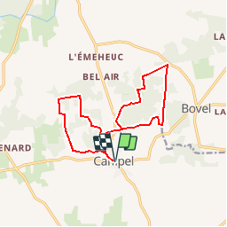
Circuit proposé par la maison du tourisme du Pays de Redon . Départ de la place de l’église de Campel. Retrouvez le circuit sur le site du Pays de Redon.
Ort
Land:
France
Region :
Bretagne
Abteilung/Provinz :
Ille-et-Vilaine
Kommune :
Val d'Anast
Standort:
Unknown
Gehen Sie:(Dec)
Gehen Sie:(UTM)
574035 ; 5309708 (30T) N.
Kommentare
Touren in der Umgebung
![Tour Wandern Val d'Anast - Les étangs de Campel - Photo](https://media.geolcdn.com/t/375/260/c389e443-e38d-43f4-8d61-580643f34610.jpg&format=jpg&maxdim=2)
![Wandern Wandern](https://static1.geolcdn.com/sitytour/trail-icons/101.png)
Les étangs de Campel
Wandern
Medium
Val d'Anast,
Bretagne,
Ille-et-Vilaine,
France
![](/images/other/stat-length.png)
10 km | 11,7 km-effort
2h 41min
![](https://static1.geolcdn.com/siteimages/upload/files/16400158638029165_repeat_loop_refresh_sync_direction_icon.png)
Ja
![Tour Wandern Val d'Anast - circuit des landes et des étangs. Campel - Photo](https://media.geolcdn.com/t/375/260/ext.jpg?maxdim=2&url=https%3A%2F%2Fservices.sitytrail.com%2FGeolivesWS%2FDownloadMedia.ashx%3FTrailID%3D210650%26Media%3D20130806123049.jpg)
![Wandern Wandern](https://static1.geolcdn.com/sitytour/trail-icons/101.png)
circuit des landes et des étangs. Campel
Wandern
Sehr leicht
(1)
Val d'Anast,
Bretagne,
Ille-et-Vilaine,
France
![](/images/other/stat-length.png)
14,9 km | 17,8 km-effort
3h 34min
![](https://static1.geolcdn.com/siteimages/upload/files/16400158638029165_repeat_loop_refresh_sync_direction_icon.png)
Ja
![Tour Zu Fuß Maxent - Circuit de L'Emeheuc - Photo](https://media.geolcdn.com/t/375/260/ext.jpg?maxdim=2&url=https%3A%2F%2Fstatic1.geolcdn.com%2Fsiteimages%2Fupload%2Ffiles%2F1545311037marcheuse_200dpi.jpg)
![Zu Fuß Zu Fuß](https://static1.geolcdn.com/sitytour/trail-icons/100.png)
Circuit de L'Emeheuc
Zu Fuß
Einfach
Maxent,
Bretagne,
Ille-et-Vilaine,
France
![](/images/other/stat-length.png)
7,2 km | 8,5 km-effort
1h 55min
![](https://static1.geolcdn.com/siteimages/upload/files/16400158638029165_repeat_loop_refresh_sync_direction_icon.png)
Ja
![Tour Wandern Bovel - Circuit du Bois de Cent Jours - Bovel - Photo](https://media.geolcdn.com/t/375/260/ext.jpg?maxdim=2&url=https%3A%2F%2Fservices.sitytrail.com%2FGeolivesWS%2FDownloadMedia.ashx%3FTrailID%3D111752%26Media%3D8178_2.jpg)
![Wandern Wandern](https://static1.geolcdn.com/sitytour/trail-icons/101.png)
Circuit du Bois de Cent Jours - Bovel
Wandern
Einfach
Bovel,
Bretagne,
Ille-et-Vilaine,
France
![](/images/other/stat-length.png)
5,6 km | 7 km-effort
1h 19min
![](https://static1.geolcdn.com/siteimages/upload/files/16400158638029165_repeat_loop_refresh_sync_direction_icon.png)
Ja
![Tour Hybrid-Bike La Chapelle-Bouëxic - lcb guipry guer - Photo](https://media.geolcdn.com/t/375/260/ext.jpg?maxdim=2&url=https%3A%2F%2Fstatic1.geolcdn.com%2Fsiteimages%2Fupload%2Ffiles%2F1524743154velo.jpg)
![Hybrid-Bike Hybrid-Bike](https://static1.geolcdn.com/sitytour/trail-icons/203.png)
lcb guipry guer
Hybrid-Bike
Medium
La Chapelle-Bouëxic,
Bretagne,
Ille-et-Vilaine,
France
![](/images/other/stat-length.png)
56 km | 63 km-effort
3h 13min
![](https://static1.geolcdn.com/siteimages/upload/files/16400158638029165_repeat_loop_refresh_sync_direction_icon.png)
Ja
![Tour Wandern Val d'Anast - Campel - Photo](https://media.geolcdn.com/t/375/260/ext.jpg?maxdim=2&url=https%3A%2F%2Fstatic1.geolcdn.com%2Fsiteimages%2Fupload%2Ffiles%2F1553511878bg_sport_marche.png)
![Wandern Wandern](https://static1.geolcdn.com/sitytour/trail-icons/101.png)
Campel
Wandern
Medium
Val d'Anast,
Bretagne,
Ille-et-Vilaine,
France
![](/images/other/stat-length.png)
6,7 km | 7,7 km-effort
2h 39min
![](https://static1.geolcdn.com/siteimages/upload/files/16400158638029165_repeat_loop_refresh_sync_direction_icon.png)
Nein
![Tour Wandern Val d'Anast - campel - Photo](https://media.geolcdn.com/t/375/260/ext.jpg?maxdim=2&url=https%3A%2F%2Fstatic1.geolcdn.com%2Fsiteimages%2Fupload%2Ffiles%2F1553511878bg_sport_marche.png)
![Wandern Wandern](https://static1.geolcdn.com/sitytour/trail-icons/101.png)
campel
Wandern
Medium
Val d'Anast,
Bretagne,
Ille-et-Vilaine,
France
![](/images/other/stat-length.png)
14,1 km | 16,7 km-effort
3h 7min
![](https://static1.geolcdn.com/siteimages/upload/files/16400158638029165_repeat_loop_refresh_sync_direction_icon.png)
Ja
![Tour Wandern Val d'Anast - campeljuin - Photo](https://media.geolcdn.com/t/375/260/ext.jpg?maxdim=2&url=https%3A%2F%2Fstatic1.geolcdn.com%2Fsiteimages%2Fupload%2Ffiles%2F1553511878bg_sport_marche.png)
![Wandern Wandern](https://static1.geolcdn.com/sitytour/trail-icons/101.png)
campeljuin
Wandern
Sehr leicht
Val d'Anast,
Bretagne,
Ille-et-Vilaine,
France
![](/images/other/stat-length.png)
12,2 km | 14,4 km-effort
2h 46min
![](https://static1.geolcdn.com/siteimages/upload/files/16400158638029165_repeat_loop_refresh_sync_direction_icon.png)
Nein
![Tour sport Val d'Anast - 2023-03-02_11h00m56_SityTrail - 3565569 - Campel_TA_Rando A+ - Photo](https://media.geolcdn.com/t/375/260/ext.jpg?maxdim=2&url=https%3A%2F%2Fsecurestorage.geolives.com%2Fsitytour%2Ftrail-bg%2Fdefault.jpg)
2023-03-02_11h00m56_SityTrail - 3565569 - Campel_TA_Rando A+
sport
Sehr leicht
Val d'Anast,
Bretagne,
Ille-et-Vilaine,
France
![](/images/other/stat-length.png)
13,2 km | 15,8 km-effort
Unbekannt
![](https://static1.geolcdn.com/siteimages/upload/files/16400158638029165_repeat_loop_refresh_sync_direction_icon.png)
Nein
Sans intérêt réserver pour une balade le dimanche d'automne.
Balisage très moyen sur une partie du sentier.