![](/images/other/stat-length.png)
![Tour Wandern Bangor - Tour de Belle-Ile - étape 3 : Port Goulphar - Locmaria - Photo](https://media.geolcdn.com/t/1900/400/ext.pjpeg?maxdim=2&url=https%3A%2F%2Fstatic1.geolcdn.com%2Fsiteimages%2Fupload%2Ffiles%2F1553511878bg_sport_marche.png)
Tour de Belle-Ile - étape 3 : Port Goulphar - Locmaria
cathel11
Benutzer
![Länge](/images/other/stat-length.png)
![Maximale Höhe](https://static1.geolcdn.com/siteimages/upload/files/1508320355ic_sort_altitude_max_24dp.png)
![Positive Höhendifferenz](https://static1.geolcdn.com/siteimages/upload/files/1508320355ic_sort_den_pos_24dp.png)
![Km-Effort](/images/other/stat-length.png)
![Min. Höhe](https://static1.geolcdn.com/siteimages/upload/files/1508320355ic_sort_altitude_min_24dp.png)
![Negative Höhendifferenz](https://static1.geolcdn.com/siteimages/upload/files/1508320355ic_sort_den_neg_24dp.png)
![Boucle](https://static1.geolcdn.com/siteimages/upload/files/16400158638029165_repeat_loop_refresh_sync_direction_icon.png)
![Wandern](https://static1.geolcdn.com/sitytour/trail-icons/101.png)
6h50
Schwierigkeit : Unbekannt
![Scannen Sie diesen QR-Code, um die Tour in der SityTrail-Anwendung zu öffnen](https://capi.geolives.com/qq0zvz2zws4bq2lad0pu/sitytour/trails/1116209/qr.png?size=200)
Kostenlosegpshiking-Anwendung
Über SityTrail
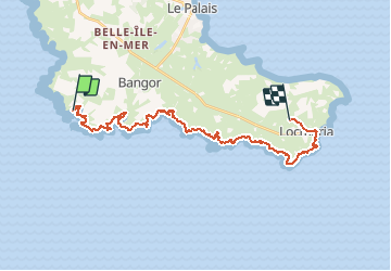
Tour Wandern von 25 km verfügbar auf Bretagne, Morbihan, Bangor. Diese Tour wird von cathel11 vorgeschlagen.
Beschreibung
3ème jour : Nous quittons notre hôtel, direction Locmaria notre prochaine étape.
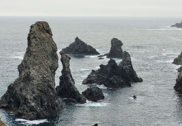
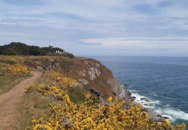
A Port Goulphar, il faut contourner l'anse en contrebas des hôtels et suivre le sentie côtier. Passer à la pointe du Talut, à Bornor puis au fond de l'anse de Port Kérel.
Au niveau de Kerguelen, possibilité d'aller jusqu'à Bangor (2km) pour se ravitailler.
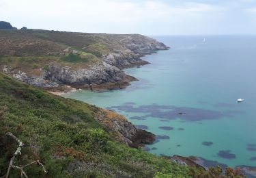
Après le fond de l'anse de Port Kérel, nous passons à la hauteur de l'ïle de Bangor, pour parvenir à la crique de Toul Boulzado. Le sentier nous mène ensuite à la pointe du Grand village puis à la pointe de Saint-Marc.
De là, direction Locmaria à l'intérieur des terres (200 mètres)puis nous prenons la direction de Keroulep.
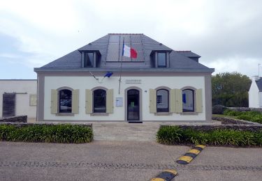
Arrivée à notre chambre d'hôte chez Claire et Alain GUILLOTTE-BODENAND.
Ort
Kommentare
Touren in der Umgebung
![Tour Wandern Bangor - bangor - Photo](https://media.geolcdn.com/t/375/260/ext.jpg?maxdim=2&url=https%3A%2F%2Fservices.sitytrail.com%2FGeolivesWS%2FDownloadMedia.ashx%3FTrailID%3D308558%26Media%3Dfix__20140530104824.jpg)
![Wandern Wandern](https://static1.geolcdn.com/sitytour/trail-icons/101.png)
Wandern
![](/images/other/stat-length.png)
![](https://static1.geolcdn.com/siteimages/upload/files/16400158638029165_repeat_loop_refresh_sync_direction_icon.png)
![Tour Wandern Bangor - Belle île en mer - Photo](https://media.geolcdn.com/t/375/260/3a7f4183-98be-4dc7-9aad-ed1e320f25b2.jpg&format=jpg&maxdim=2)
![Wandern Wandern](https://static1.geolcdn.com/sitytour/trail-icons/101.png)
Wandern
![](/images/other/stat-length.png)
![](https://static1.geolcdn.com/siteimages/upload/files/16400158638029165_repeat_loop_refresh_sync_direction_icon.png)
![Tour Wandern Bangor - J3 - Port Coton - Locmaria - 24 km - Photo](https://media.geolcdn.com/t/375/260/ext.jpg?maxdim=2&url=https%3A%2F%2Fstatic1.geolcdn.com%2Fsiteimages%2Fupload%2Ffiles%2F1553511878bg_sport_marche.png)
![Wandern Wandern](https://static1.geolcdn.com/sitytour/trail-icons/101.png)
Wandern
![](/images/other/stat-length.png)
![](https://static1.geolcdn.com/siteimages/upload/files/16400158638029165_repeat_loop_refresh_sync_direction_icon.png)
![Tour Wandern Bangor - 2-Port Coton - l'Apothicairerie à Belle Île en mer - Photo](https://media.geolcdn.com/t/375/260/5b3aba3d-6201-477b-b54e-bfc76b8e3758.jpg&format=jpg&maxdim=2)
![Wandern Wandern](https://static1.geolcdn.com/sitytour/trail-icons/101.png)
Wandern
![](/images/other/stat-length.png)
![](https://static1.geolcdn.com/siteimages/upload/files/16400158638029165_repeat_loop_refresh_sync_direction_icon.png)
![Tour Wandern Bangor - 3-Port Coton - Locmaria à Belle Île en mer - Photo](https://media.geolcdn.com/t/375/260/61d9dfb6-e967-452b-8601-de89fcd53ae3.jpg&format=jpg&maxdim=2)
![Wandern Wandern](https://static1.geolcdn.com/sitytour/trail-icons/101.png)
Wandern
![](/images/other/stat-length.png)
![](https://static1.geolcdn.com/siteimages/upload/files/16400158638029165_repeat_loop_refresh_sync_direction_icon.png)
![Tour Wandern Bangor - GR340 BELLE-ILE jour 3 - Grand Large - Locmaria - Photo](https://media.geolcdn.com/t/375/260/8b1423fb-d98c-4bac-8258-679bd03de44c.jpg&format=jpg&maxdim=2)
![Wandern Wandern](https://static1.geolcdn.com/sitytour/trail-icons/101.png)
Wandern
![](/images/other/stat-length.png)
![](https://static1.geolcdn.com/siteimages/upload/files/16400158638029165_repeat_loop_refresh_sync_direction_icon.png)
![Tour Wandern Bangor - aiguilles de port Cotton - Photo](https://media.geolcdn.com/t/375/260/351bb440-7c45-45af-8626-d2213c10b99a.jpg&format=jpg&maxdim=2)
![Wandern Wandern](https://static1.geolcdn.com/sitytour/trail-icons/101.png)
Wandern
![](/images/other/stat-length.png)
![](https://static1.geolcdn.com/siteimages/upload/files/16400158638029165_repeat_loop_refresh_sync_direction_icon.png)
![Tour Zu Fuß Bangor - Sentier du Stang Per - Photo](https://media.geolcdn.com/t/375/260/79d44e98-b1d5-40ac-81c7-6fc59deba8b2.jpeg&format=jpg&maxdim=2)
![Zu Fuß Zu Fuß](https://static1.geolcdn.com/sitytour/trail-icons/100.png)
Zu Fuß
![](/images/other/stat-length.png)
![](https://static1.geolcdn.com/siteimages/upload/files/16400158638029165_repeat_loop_refresh_sync_direction_icon.png)
![Tour Wandern Bangor - port cotton,Locmaria - Photo](https://media.geolcdn.com/t/375/260/8341e71a-a817-404b-9455-cd0135701718.jpg&format=jpg&maxdim=2)
![Wandern Wandern](https://static1.geolcdn.com/sitytour/trail-icons/101.png)
Wandern
![](/images/other/stat-length.png)
![](https://static1.geolcdn.com/siteimages/upload/files/16400158638029165_repeat_loop_refresh_sync_direction_icon.png)