![](/images/other/stat-length.png)
![Tour Schneeschuhwandern Bellevaux - Lac de Pététoz - Photo](https://media.geolcdn.com/t/1900/400/ext.pjpeg?maxdim=2&url=https%3A%2F%2Fservices.sitytrail.com%2FGeolivesWS%2FDownloadMedia.ashx%3FTrailID%3D1116113%26Media%3D20190226123552.jpg)
Lac de Pététoz
petole
Benutzer
![Länge](/images/other/stat-length.png)
Länge
6,2 km
![Maximale Höhe](https://static1.geolcdn.com/siteimages/upload/files/1508320355ic_sort_altitude_max_24dp.png)
Maximale Höhe
1567 m
![Positive Höhendifferenz](https://static1.geolcdn.com/siteimages/upload/files/1508320355ic_sort_den_pos_24dp.png)
Positive Höhendifferenz
417 m
![Km-Effort](/images/other/stat-length.png)
Km-Effort
11,9 km
![Min. Höhe](https://static1.geolcdn.com/siteimages/upload/files/1508320355ic_sort_altitude_min_24dp.png)
Min. Höhe
1134 m
![Negative Höhendifferenz](https://static1.geolcdn.com/siteimages/upload/files/1508320355ic_sort_den_neg_24dp.png)
Negative Höhendifferenz
441 m
![Boucle](https://static1.geolcdn.com/siteimages/upload/files/16400158638029165_repeat_loop_refresh_sync_direction_icon.png)
Boucle
Ja
Erstellungsdatum :
2019-03-31 17:48:53.31
Letzte Änderung :
2019-03-31 17:48:53.31
![Schneeschuhwandern](https://static1.geolcdn.com/sitytour/trail-icons/504.png)
2h32
Schwierigkeit : Schwierig
![Scannen Sie diesen QR-Code, um die Tour in der SityTrail-Anwendung zu öffnen](https://capi.geolives.com/qq0zvz2zws4bq2lad0pu/sitytour/trails/1116113/qr.png?size=200)
Kostenlosegpshiking-Anwendung
Über SityTrail
Tour Schneeschuhwandern von 6,2 km verfügbar auf Auvergne-Rhone-Alpen, Hochsavoyen, Bellevaux. Diese Tour wird von petole vorgeschlagen.
Beschreibung
Circuit facile jusqu'au pied du lac suivi de 10 minutes en aval et de 20 en amont du lac d'une zone raide et technique sur terrain mixte en sous-bois. A privilégier par neige dure.
Ort
Land:
France
Region :
Auvergne-Rhone-Alpen
Abteilung/Provinz :
Hochsavoyen
Kommune :
Bellevaux
Standort:
Unknown
Gehen Sie:(Dec)
Gehen Sie:(UTM)
313048 ; 5119958 (32T) N.
Kommentare
Touren in der Umgebung
![Tour Nordic Walking Bellevaux - tour du roc - Photo](https://media.geolcdn.com/t/375/260/ext.jpg?maxdim=2&url=https%3A%2F%2Fservices.sitytrail.com%2FGeolivesWS%2FDownloadMedia.ashx%3FTrailID%3D168665%26Media%3D20130105113055.jpeg)
![Nordic Walking Nordic Walking](https://static1.geolcdn.com/sitytour/trail-icons/102.png)
tour du roc
Nordic Walking
Medium
(1)
Bellevaux,
Auvergne-Rhone-Alpen,
Hochsavoyen,
France
![](/images/other/stat-length.png)
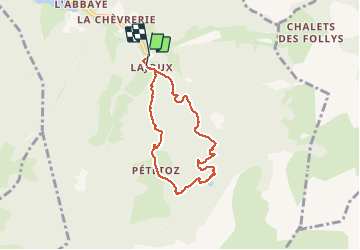
26 km | 53 km-effort
4h 7min
![](https://static1.geolcdn.com/siteimages/upload/files/16400158638029165_repeat_loop_refresh_sync_direction_icon.png)
Ja
![Tour Wandern Bellevaux - La Haute Pointe 1968m, depuis le Plan des Rasses - Photo](https://media.geolcdn.com/t/375/260/ext.jpg?maxdim=2&url=https%3A%2F%2Fservices.sitytrail.com%2FGeolivesWS%2FDownloadMedia.ashx%3FTrailID%3D316834%26Media%3D15897_1.jpg)
![Wandern Wandern](https://static1.geolcdn.com/sitytour/trail-icons/101.png)
La Haute Pointe 1968m, depuis le Plan des Rasses
Wandern
Medium
(1)
Bellevaux,
Auvergne-Rhone-Alpen,
Hochsavoyen,
France
![](/images/other/stat-length.png)
9,8 km | 21 km-effort
5h 30min
![](https://static1.geolcdn.com/siteimages/upload/files/16400158638029165_repeat_loop_refresh_sync_direction_icon.png)
Ja
![Tour Wandern Mieussy - La Pointe de Chavasse, 2012m - Photo](https://media.geolcdn.com/t/375/260/ext.jpg?maxdim=2&url=https%3A%2F%2Fservices.sitytrail.com%2FGeolivesWS%2FDownloadMedia.ashx%3FTrailID%3D172620%26Media%3D13985_1.jpg)
![Wandern Wandern](https://static1.geolcdn.com/sitytour/trail-icons/101.png)
La Pointe de Chavasse, 2012m
Wandern
Schwierig
(1)
Mieussy,
Auvergne-Rhone-Alpen,
Hochsavoyen,
France
![](/images/other/stat-length.png)
9,9 km | 18,2 km-effort
4h 45min
![](https://static1.geolcdn.com/siteimages/upload/files/16400158638029165_repeat_loop_refresh_sync_direction_icon.png)
Ja
![Tour Wandern Bellevaux - Pointe d'Ireuse - Photo](https://media.geolcdn.com/t/375/260/ext.jpg?maxdim=2&url=https%3A%2F%2Fstatic1.geolcdn.com%2Fsiteimages%2Fupload%2Ffiles%2F1553511878bg_sport_marche.png)
![Wandern Wandern](https://static1.geolcdn.com/sitytour/trail-icons/101.png)
Pointe d'Ireuse
Wandern
Medium
(2)
Bellevaux,
Auvergne-Rhone-Alpen,
Hochsavoyen,
France
![](/images/other/stat-length.png)
11,3 km | 23 km-effort
5h 47min
![](https://static1.geolcdn.com/siteimages/upload/files/16400158638029165_repeat_loop_refresh_sync_direction_icon.png)
Ja
![Tour Wandern Taninges - Balade autour de Beauregard - Photo](https://media.geolcdn.com/t/375/260/b9aaba51-d4ef-43fe-903b-7522c0326849.jpg&format=jpg&maxdim=2)
![Wandern Wandern](https://static1.geolcdn.com/sitytour/trail-icons/101.png)
Balade autour de Beauregard
Wandern
Medium
Taninges,
Auvergne-Rhone-Alpen,
Hochsavoyen,
France
![](/images/other/stat-length.png)
5,9 km | 10,5 km-effort
1h 39min
![](https://static1.geolcdn.com/siteimages/upload/files/16400158638029165_repeat_loop_refresh_sync_direction_icon.png)
Ja
![Tour Wandern Mieussy - le tour de la haute pointe - Photo](https://media.geolcdn.com/t/375/260/6384457b-18fc-4356-9b38-d58a4cfbdf11.jpg&format=jpg&maxdim=2)
![Wandern Wandern](https://static1.geolcdn.com/sitytour/trail-icons/101.png)
le tour de la haute pointe
Wandern
Medium
Mieussy,
Auvergne-Rhone-Alpen,
Hochsavoyen,
France
![](/images/other/stat-length.png)
6,4 km | 12,7 km-effort
3h 38min
![](https://static1.geolcdn.com/siteimages/upload/files/16400158638029165_repeat_loop_refresh_sync_direction_icon.png)
Ja
![Tour Wandern Mieussy - CHABLAIS: TOUR DE LA POINTE DE CHALUNE - Photo](https://media.geolcdn.com/t/375/260/32569742-e5b7-4156-9721-a914bf03f96e.jpg&format=jpg&maxdim=2)
![Wandern Wandern](https://static1.geolcdn.com/sitytour/trail-icons/101.png)
CHABLAIS: TOUR DE LA POINTE DE CHALUNE
Wandern
Medium
Mieussy,
Auvergne-Rhone-Alpen,
Hochsavoyen,
France
![](/images/other/stat-length.png)
12,2 km | 23 km-effort
5h 0min
![](https://static1.geolcdn.com/siteimages/upload/files/16400158638029165_repeat_loop_refresh_sync_direction_icon.png)
Ja
![Tour Wandern Mieussy - CHABLAIS: COLS CHALUNE - VESINAZ - Photo](https://media.geolcdn.com/t/375/260/a77ba278-7b9d-496e-81c3-caca4c1536a4.jpg&format=jpg&maxdim=2)
![Wandern Wandern](https://static1.geolcdn.com/sitytour/trail-icons/101.png)
CHABLAIS: COLS CHALUNE - VESINAZ
Wandern
Einfach
Mieussy,
Auvergne-Rhone-Alpen,
Hochsavoyen,
France
![](/images/other/stat-length.png)
6,4 km | 12 km-effort
2h 45min
![](https://static1.geolcdn.com/siteimages/upload/files/16400158638029165_repeat_loop_refresh_sync_direction_icon.png)
Ja
![Tour Wandern Bellevaux - 2021-10-15 La Pointe de La Gay - Photo](https://media.geolcdn.com/t/375/260/7b0efd93-8b0c-4d5f-a9c8-7f3d48655447.jpg&format=jpg&maxdim=2)
![Wandern Wandern](https://static1.geolcdn.com/sitytour/trail-icons/101.png)
2021-10-15 La Pointe de La Gay
Wandern
Medium
Bellevaux,
Auvergne-Rhone-Alpen,
Hochsavoyen,
France
![](/images/other/stat-length.png)
11,2 km | 21 km-effort
5h 5min
![](https://static1.geolcdn.com/siteimages/upload/files/16400158638029165_repeat_loop_refresh_sync_direction_icon.png)
Ja