![](/images/other/stat-length.png)
![Tour Wandern Saint-Symphorien-sous-Chomérac - Saint-Symphorien-sous-Chomérac n° 2 - Photo](https://media.geolcdn.com/t/1900/400/ext.pjpeg?maxdim=2&url=https%3A%2F%2Fservices.sitytrail.com%2FGeolivesWS%2FDownloadMedia.ashx%3FTrailID%3D111488%26Media%3D7446_1.jpg)
Saint-Symphorien-sous-Chomérac n° 2
tracegps
Benutzer
![Länge](/images/other/stat-length.png)
Länge
5,5 km
![Maximale Höhe](https://static1.geolcdn.com/siteimages/upload/files/1508320355ic_sort_altitude_max_24dp.png)
Maximale Höhe
278 m
![Positive Höhendifferenz](https://static1.geolcdn.com/siteimages/upload/files/1508320355ic_sort_den_pos_24dp.png)
Positive Höhendifferenz
158 m
![Km-Effort](/images/other/stat-length.png)
Km-Effort
7,6 km
![Min. Höhe](https://static1.geolcdn.com/siteimages/upload/files/1508320355ic_sort_altitude_min_24dp.png)
Min. Höhe
139 m
![Negative Höhendifferenz](https://static1.geolcdn.com/siteimages/upload/files/1508320355ic_sort_den_neg_24dp.png)
Negative Höhendifferenz
157 m
![Boucle](https://static1.geolcdn.com/siteimages/upload/files/16400158638029165_repeat_loop_refresh_sync_direction_icon.png)
Boucle
Ja
Erstellungsdatum :
2014-12-10 00:00:00.0
Letzte Änderung :
2014-12-10 00:00:00.0
![Wandern](https://static1.geolcdn.com/sitytour/trail-icons/101.png)
1h45
Schwierigkeit : Einfach
![Scannen Sie diesen QR-Code, um die Tour in der SityTrail-Anwendung zu öffnen](https://capi.geolives.com/qq0zvz2zws4bq2lad0pu/sitytour/trails/111488/qr.png?size=200)
Kostenlosegpshiking-Anwendung
Über SityTrail
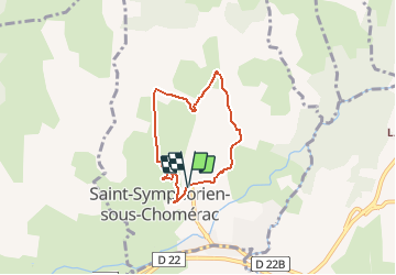
Tour Wandern von 5,5 km verfügbar auf Auvergne-Rhone-Alpen, Ardèche, Saint-Symphorien-sous-Chomérac. Diese Tour wird von tracegps vorgeschlagen.
Beschreibung
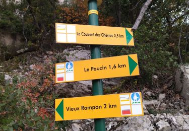
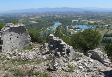
Circuit proposé par la mairie de Saint-Symphorien-sous-Chomérac et l’office de tourisme de Cruas et la Communauté de communes Barrès-Coiron. Départ de la mairie de Saint-Symphorien-sous-Chomérac. Retrouvez 2 circuits sur le site de la mairie.
Ort
Land:
France
Region :
Auvergne-Rhone-Alpen
Abteilung/Provinz :
Ardèche
Kommune :
Saint-Symphorien-sous-Chomérac
Standort:
Unknown
Gehen Sie:(Dec)
Gehen Sie:(UTM)
634968 ; 4953216 (31T) N.
Kommentare
Touren in der Umgebung
![Tour Wandern Le Pouzin - 07 balcon Ouvèze pouzin - Photo](https://media.geolcdn.com/t/375/260/e1f893af-61d3-4cd8-a418-b5cde15229b8.jpg&format=jpg&maxdim=2)
![Wandern Wandern](https://static1.geolcdn.com/sitytour/trail-icons/101.png)
07 balcon Ouvèze pouzin
Wandern
Medium
(1)
Le Pouzin,
Auvergne-Rhone-Alpen,
Ardèche,
France
![](/images/other/stat-length.png)
15,3 km | 24 km-effort
6h 58min
![](https://static1.geolcdn.com/siteimages/upload/files/16400158638029165_repeat_loop_refresh_sync_direction_icon.png)
Nein
![Tour Wandern Saint-Symphorien-sous-Chomérac - St-Symphorien-sous-Chomerac](https://media.geolcdn.com/t/375/260/b69406d1-b9d6-4e5a-81ea-edd2877facfa.jpg&format=jpg&maxdim=2)
![Wandern Wandern](https://static1.geolcdn.com/sitytour/trail-icons/101.png)
St-Symphorien-sous-Chomerac "Col de Linte"11km.
Wandern
Schwierig
(2)
Saint-Symphorien-sous-Chomérac,
Auvergne-Rhone-Alpen,
Ardèche,
France
![](/images/other/stat-length.png)
11,4 km | 15,8 km-effort
3h 35min
![](https://static1.geolcdn.com/siteimages/upload/files/16400158638029165_repeat_loop_refresh_sync_direction_icon.png)
Ja
![Tour Wandern Le Pouzin - Le Pouzin : Couvent des Chèvres 8km. - Photo](https://media.geolcdn.com/t/375/260/3b82990a-638d-4172-b8c9-858402e07317.jpg&format=jpg&maxdim=2)
![Wandern Wandern](https://static1.geolcdn.com/sitytour/trail-icons/101.png)
Le Pouzin : Couvent des Chèvres 8km.
Wandern
Schwierig
(1)
Le Pouzin,
Auvergne-Rhone-Alpen,
Ardèche,
France
![](/images/other/stat-length.png)
8,2 km | 12,8 km-effort
2h 55min
![](https://static1.geolcdn.com/siteimages/upload/files/16400158638029165_repeat_loop_refresh_sync_direction_icon.png)
Ja
![Tour Wandern Saint-Lager-Bressac - 2021-11-20_13h45m12_St Lager Bressac Voie verte 6km.gpx (1).xml - Photo](https://media.geolcdn.com/t/375/260/ext.jpg?maxdim=2&url=https%3A%2F%2Fstatic1.geolcdn.com%2Fsiteimages%2Fupload%2Ffiles%2F1553511878bg_sport_marche.png)
![Wandern Wandern](https://static1.geolcdn.com/sitytour/trail-icons/101.png)
2021-11-20_13h45m12_St Lager Bressac Voie verte 6km.gpx (1).xml
Wandern
Medium
(2)
Saint-Lager-Bressac,
Auvergne-Rhone-Alpen,
Ardèche,
France
![](/images/other/stat-length.png)
5,8 km | 7,4 km-effort
1h 40min
![](https://static1.geolcdn.com/siteimages/upload/files/16400158638029165_repeat_loop_refresh_sync_direction_icon.png)
Ja
![Tour Wandern Baix - 07 baix 07 01 23 - Photo](https://media.geolcdn.com/t/375/260/6f38ce73-6c19-4eb6-98ff-8ad86517b683.jpg&format=jpg&maxdim=2)
![Wandern Wandern](https://static1.geolcdn.com/sitytour/trail-icons/101.png)
07 baix 07 01 23
Wandern
Medium
Baix,
Auvergne-Rhone-Alpen,
Ardèche,
France
![](/images/other/stat-length.png)
16,5 km | 28 km-effort
7h 5min
![](https://static1.geolcdn.com/siteimages/upload/files/16400158638029165_repeat_loop_refresh_sync_direction_icon.png)
Ja
![Tour Wandern Le Pouzin - 07 pouzin couvent des chèvres zel - Photo](https://media.geolcdn.com/t/375/260/27e3009c-a2c9-4a5b-9e79-278e69de3846.jpg&format=jpg&maxdim=2)
![Wandern Wandern](https://static1.geolcdn.com/sitytour/trail-icons/101.png)
07 pouzin couvent des chèvres zel
Wandern
Medium
Le Pouzin,
Auvergne-Rhone-Alpen,
Ardèche,
France
![](/images/other/stat-length.png)
15,2 km | 24 km-effort
6h 32min
![](https://static1.geolcdn.com/siteimages/upload/files/16400158638029165_repeat_loop_refresh_sync_direction_icon.png)
Ja
![Wandern Wandern](https://static1.geolcdn.com/sitytour/trail-icons/101.png)
2023-10-29_11h20m28_Le Pouzin-Couvent Chèvres-Falaises 15km
Wandern
Sehr schwierig
Le Pouzin,
Auvergne-Rhone-Alpen,
Ardèche,
France
![](/images/other/stat-length.png)
14,7 km | 23 km-effort
5h 13min
![](https://static1.geolcdn.com/siteimages/upload/files/16400158638029165_repeat_loop_refresh_sync_direction_icon.png)
Ja
![Tour Wandern Alissas - 07 Alissas rochessauve zel 23.11.22 - Photo](https://media.geolcdn.com/t/375/260/4287b664-a3fb-4af1-9196-43ecf378ac6d.jpg&format=jpg&maxdim=2)
![Wandern Wandern](https://static1.geolcdn.com/sitytour/trail-icons/101.png)
07 Alissas rochessauve zel 23.11.22
Wandern
Einfach
Alissas,
Auvergne-Rhone-Alpen,
Ardèche,
France
![](/images/other/stat-length.png)
15,3 km | 22 km-effort
6h 5min
![](https://static1.geolcdn.com/siteimages/upload/files/16400158638029165_repeat_loop_refresh_sync_direction_icon.png)
Ja
![Tour Wandern Saint-Lager-Bressac - 2021-11-20_13h01m29_St Lager Bressac 6km.xml - Photo](https://media.geolcdn.com/t/375/260/ext.jpg?maxdim=2&url=https%3A%2F%2Fstatic1.geolcdn.com%2Fsiteimages%2Fupload%2Ffiles%2F1553511878bg_sport_marche.png)
![Wandern Wandern](https://static1.geolcdn.com/sitytour/trail-icons/101.png)
2021-11-20_13h01m29_St Lager Bressac 6km.xml
Wandern
Einfach
(1)
Saint-Lager-Bressac,
Auvergne-Rhone-Alpen,
Ardèche,
France
![](/images/other/stat-length.png)
6,7 km | 9,1 km-effort
2h 30min
![](https://static1.geolcdn.com/siteimages/upload/files/16400158638029165_repeat_loop_refresh_sync_direction_icon.png)
Ja