![](/images/other/stat-length.png)
![Tour Wandern Cuise-la-Motte - Cuise-la-Motte - Photo](https://media.geolcdn.com/t/1900/400/ext.pjpeg?maxdim=2&url=https%3A%2F%2Fservices.sitytrail.com%2FGeolivesWS%2FDownloadMedia.ashx%3FTrailID%3D111270%26Media%3D6897_2.jpg)
Cuise-la-Motte
tracegps
Benutzer
![Länge](/images/other/stat-length.png)
Länge
6,4 km
![Maximale Höhe](https://static1.geolcdn.com/siteimages/upload/files/1508320355ic_sort_altitude_max_24dp.png)
Maximale Höhe
142 m
![Positive Höhendifferenz](https://static1.geolcdn.com/siteimages/upload/files/1508320355ic_sort_den_pos_24dp.png)
Positive Höhendifferenz
155 m
![Km-Effort](/images/other/stat-length.png)
Km-Effort
8,5 km
![Min. Höhe](https://static1.geolcdn.com/siteimages/upload/files/1508320355ic_sort_altitude_min_24dp.png)
Min. Höhe
47 m
![Negative Höhendifferenz](https://static1.geolcdn.com/siteimages/upload/files/1508320355ic_sort_den_neg_24dp.png)
Negative Höhendifferenz
155 m
![Boucle](https://static1.geolcdn.com/siteimages/upload/files/16400158638029165_repeat_loop_refresh_sync_direction_icon.png)
Boucle
Ja
Erstellungsdatum :
2014-12-10 00:00:00.0
Letzte Änderung :
2014-12-10 00:00:00.0
![Wandern](https://static1.geolcdn.com/sitytour/trail-icons/101.png)
1h34
Schwierigkeit : Einfach
![Scannen Sie diesen QR-Code, um die Tour in der SityTrail-Anwendung zu öffnen](https://capi.geolives.com/qq0zvz2zws4bq2lad0pu/sitytour/trails/111270/qr.png?size=200)
Kostenlosegpshiking-Anwendung
Über SityTrail
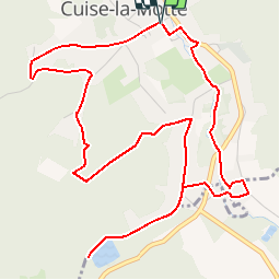
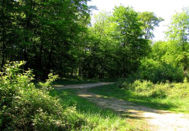
Tour Wandern von 6,4 km verfügbar auf Nordfrankreich, Oise, Cuise-la-Motte. Diese Tour wird von tracegps vorgeschlagen.
Beschreibung
Circuit proposé par l'Office de Tourisme de Pierrefonds. Départ de la place de la mairie de Cuise-la-Motte. Retrouvez ce circuit sur le site de l’Office de Tourisme de Pierrefonds. Ce circuit a été numérisé par les randonneurs du CODEPEM. Merci à Jean-Marie.
Ort
Land:
France
Region :
Nordfrankreich
Abteilung/Provinz :
Oise
Kommune :
Cuise-la-Motte
Standort:
Unknown
Gehen Sie:(Dec)
Gehen Sie:(UTM)
500435 ; 5470453 (31U) N.
Kommentare
Touren in der Umgebung
![Tour Wandern Rethondes - en forêt de Laigue_4_08_2019_Mont du Fouilleux_Mont des Singes_Marais de Francière - Photo](https://media.geolcdn.com/t/375/260/ext.jpg?maxdim=2&url=https%3A%2F%2Fmedia.geolcdn.com%2Ff%2F08ad259b-3ca3-413b-96a0-73a4649eb114.JPG)
![Wandern Wandern](https://static1.geolcdn.com/sitytour/trail-icons/101.png)
en forêt de Laigue_4_08_2019_Mont du Fouilleux_Mont des Singes_Marais de Fran...
Wandern
Sehr schwierig
(1)
Rethondes,
Nordfrankreich,
Oise,
France
![](/images/other/stat-length.png)
14,8 km | 17,7 km-effort
4h 49min
![](https://static1.geolcdn.com/siteimages/upload/files/16400158638029165_repeat_loop_refresh_sync_direction_icon.png)
Ja
![Tour Zu Fuß Pierrefonds - Le Voliard - Photo](https://media.geolcdn.com/t/375/260/ext.jpg?maxdim=2&url=https%3A%2F%2Fmedia.geolcdn.com%2Ff%2F4781613a-076f-4ad8-be25-8d021ddb8fa3.jpeg)
![Zu Fuß Zu Fuß](https://static1.geolcdn.com/sitytour/trail-icons/100.png)
Le Voliard
Zu Fuß
Einfach
(1)
Pierrefonds,
Nordfrankreich,
Oise,
France
![](/images/other/stat-length.png)
5,2 km | 6,4 km-effort
1h 27min
![](https://static1.geolcdn.com/siteimages/upload/files/16400158638029165_repeat_loop_refresh_sync_direction_icon.png)
Nein
![Tour Wandern Pierrefonds - Rando couscous ATPC ARVAL 4/2/2024 - Photo](https://media.geolcdn.com/t/375/260/ext.jpg?maxdim=2&url=https%3A%2F%2Fstatic1.geolcdn.com%2Fsiteimages%2Fupload%2Ffiles%2F1553511878bg_sport_marche.png)
![Wandern Wandern](https://static1.geolcdn.com/sitytour/trail-icons/101.png)
Rando couscous ATPC ARVAL 4/2/2024
Wandern
Medium
(1)
Pierrefonds,
Nordfrankreich,
Oise,
France
![](/images/other/stat-length.png)
9,6 km | 11,9 km-effort
2h 42min
![](https://static1.geolcdn.com/siteimages/upload/files/16400158638029165_repeat_loop_refresh_sync_direction_icon.png)
Ja
![Tour Wandern Vieux-Moulin - Gorges du Han - ATPC ARVAL - Photo](https://media.geolcdn.com/t/375/260/ext.jpg?maxdim=2&url=https%3A%2F%2Fstatic1.geolcdn.com%2Fsiteimages%2Fupload%2Ffiles%2F1553511878bg_sport_marche.png)
![Wandern Wandern](https://static1.geolcdn.com/sitytour/trail-icons/101.png)
Gorges du Han - ATPC ARVAL
Wandern
Sehr leicht
(1)
Vieux-Moulin,
Nordfrankreich,
Oise,
France
![](/images/other/stat-length.png)
13,2 km | 16 km-effort
2h 42min
![](https://static1.geolcdn.com/siteimages/upload/files/16400158638029165_repeat_loop_refresh_sync_direction_icon.png)
Ja
![Tour Zu Fuß Trosly-Breuil - Le Mont-Collet - Photo](https://media.geolcdn.com/t/375/260/ext.jpg?maxdim=2&url=https%3A%2F%2Fmedia.geolcdn.com%2Ff%2Fee705b5e-8f72-4c8f-a8a8-b0b1fed66154.jpeg)
![Zu Fuß Zu Fuß](https://static1.geolcdn.com/sitytour/trail-icons/100.png)
Le Mont-Collet
Zu Fuß
Einfach
Trosly-Breuil,
Nordfrankreich,
Oise,
France
![](/images/other/stat-length.png)
4,9 km | 6,6 km-effort
1h 29min
![](https://static1.geolcdn.com/siteimages/upload/files/16400158638029165_repeat_loop_refresh_sync_direction_icon.png)
Ja
![Tour Wandern Vieux-Moulin - Gorges du Han - Photo](https://media.geolcdn.com/t/375/260/ext.jpg?maxdim=2&url=https%3A%2F%2Fstatic1.geolcdn.com%2Fsiteimages%2Fupload%2Ffiles%2F1553511878bg_sport_marche.png)
![Wandern Wandern](https://static1.geolcdn.com/sitytour/trail-icons/101.png)
Gorges du Han
Wandern
Sehr leicht
(1)
Vieux-Moulin,
Nordfrankreich,
Oise,
France
![](/images/other/stat-length.png)
11,5 km | 13,8 km-effort
2h 42min
![](https://static1.geolcdn.com/siteimages/upload/files/16400158638029165_repeat_loop_refresh_sync_direction_icon.png)
Ja
![Tour Wandern Pierrefonds - en forêt de Compiègne_30_la Tournante sous le Mont Saint-Mard - Photo](https://media.geolcdn.com/t/375/260/ext.jpg?maxdim=2&url=https%3A%2F%2Fmedia.geolcdn.com%2Ff%2Fcd27a05b-64e1-4ef9-a5d0-f58c0f1b9871.JPG)
![Wandern Wandern](https://static1.geolcdn.com/sitytour/trail-icons/101.png)
en forêt de Compiègne_30_la Tournante sous le Mont Saint-Mard
Wandern
Sehr schwierig
Pierrefonds,
Nordfrankreich,
Oise,
France
![](/images/other/stat-length.png)
17,8 km | 22 km-effort
4h 41min
![](https://static1.geolcdn.com/siteimages/upload/files/16400158638029165_repeat_loop_refresh_sync_direction_icon.png)
Ja
![Tour Wandern Trosly-Breuil - en forêt de Compiègne_28_les Tournantes sur le Mont Saint-Mard et sur le Mont Collet - Photo](https://media.geolcdn.com/t/375/260/ext.jpg?maxdim=2&url=https%3A%2F%2Fmedia.geolcdn.com%2Ff%2Fb6c30d75-8111-4451-9077-78125d2a215e.JPG)
![Wandern Wandern](https://static1.geolcdn.com/sitytour/trail-icons/101.png)
en forêt de Compiègne_28_les Tournantes sur le Mont Saint-Mard et sur le Mont...
Wandern
Schwierig
(1)
Trosly-Breuil,
Nordfrankreich,
Oise,
France
![](/images/other/stat-length.png)
13,8 km | 16,1 km-effort
3h 46min
![](https://static1.geolcdn.com/siteimages/upload/files/16400158638029165_repeat_loop_refresh_sync_direction_icon.png)
Ja
![Tour Wandern Saint-Étienne-Roilaye - en forêt de Compiègne_27_la Tournante sur la Côte de Roilaye - Photo](https://media.geolcdn.com/t/375/260/ext.jpg?maxdim=2&url=https%3A%2F%2Fmedia.geolcdn.com%2Ff%2Feb0a7062-c042-43b2-8c9b-13a60cc2e4bc.JPG)
![Wandern Wandern](https://static1.geolcdn.com/sitytour/trail-icons/101.png)
en forêt de Compiègne_27_la Tournante sur la Côte de Roilaye
Wandern
Sehr schwierig
Saint-Étienne-Roilaye,
Nordfrankreich,
Oise,
France
![](/images/other/stat-length.png)
3,8 km | 4,9 km-effort
1h 5min
![](https://static1.geolcdn.com/siteimages/upload/files/16400158638029165_repeat_loop_refresh_sync_direction_icon.png)
Ja