![](/images/other/stat-length.png)
![Tour Mountainbike Condé-sur-Vire - Boucle de Mesnil - Raoult - Photo](https://media.geolcdn.com/t/1900/400/ext.pjpeg?maxdim=2&url=https%3A%2F%2Fservices.sitytrail.com%2FGeolivesWS%2FDownloadMedia.ashx%3FTrailID%3D111222%26Media%3D6750_2.jpg)
Boucle de Mesnil - Raoult
tracegps
Benutzer
![Länge](/images/other/stat-length.png)
Länge
9,1 km
![Maximale Höhe](https://static1.geolcdn.com/siteimages/upload/files/1508320355ic_sort_altitude_max_24dp.png)
Maximale Höhe
95 m
![Positive Höhendifferenz](https://static1.geolcdn.com/siteimages/upload/files/1508320355ic_sort_den_pos_24dp.png)
Positive Höhendifferenz
148 m
![Km-Effort](/images/other/stat-length.png)
Km-Effort
11,1 km
![Min. Höhe](https://static1.geolcdn.com/siteimages/upload/files/1508320355ic_sort_altitude_min_24dp.png)
Min. Höhe
23 m
![Negative Höhendifferenz](https://static1.geolcdn.com/siteimages/upload/files/1508320355ic_sort_den_neg_24dp.png)
Negative Höhendifferenz
148 m
![Boucle](https://static1.geolcdn.com/siteimages/upload/files/16400158638029165_repeat_loop_refresh_sync_direction_icon.png)
Boucle
Ja
Erstellungsdatum :
2014-12-10 00:00:00.0
Letzte Änderung :
2014-12-10 00:00:00.0
![Mountainbike](https://static1.geolcdn.com/sitytour/trail-icons/202.png)
1h00
Schwierigkeit : Medium
![Scannen Sie diesen QR-Code, um die Tour in der SityTrail-Anwendung zu öffnen](https://capi.geolives.com/qq0zvz2zws4bq2lad0pu/sitytour/trails/111222/qr.png?size=200)
Kostenlosegpshiking-Anwendung
Über SityTrail
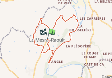
Tour Mountainbike von 9,1 km verfügbar auf Normandie, Manche, Condé-sur-Vire. Diese Tour wird von tracegps vorgeschlagen.
Beschreibung
Circuit proposé par la Communauté de Communes de Tessy sur Vire. Départ de l’église de Le Mesnil-Raoult. Retrouvez le descriptif et les commentaires du circuit sur le site de la Communauté de Communes de Tessy sur Vire.
Ort
Land:
France
Region :
Normandie
Abteilung/Provinz :
Manche
Kommune :
Condé-sur-Vire
Standort:
Le Mesnil-Raoult
Gehen Sie:(Dec)
Gehen Sie:(UTM)
641825 ; 5433177 (30U) N.
Kommentare
Touren in der Umgebung
![Tour Wandern Condé-sur-Vire - Le rocher de Ham - Photo](https://media.geolcdn.com/t/375/260/8542ca5d-28d3-484e-89d2-e8c026fb9d47.jpg&format=jpg&maxdim=2)
![Wandern Wandern](https://static1.geolcdn.com/sitytour/trail-icons/101.png)
Le rocher de Ham
Wandern
Einfach
(1)
Condé-sur-Vire,
Normandie,
Manche,
France
![](/images/other/stat-length.png)
10,9 km | 13,4 km-effort
2h 24min
![](https://static1.geolcdn.com/siteimages/upload/files/16400158638029165_repeat_loop_refresh_sync_direction_icon.png)
Ja
![Tour Wandern Condé-sur-Vire - Roches de ham - Photo](https://media.geolcdn.com/t/375/260/ext.jpg?maxdim=2&url=https%3A%2F%2Fservices.sitytrail.com%2FGeolivesWS%2FDownloadMedia.ashx%3FTrailID%3D267550%26Media%3Dfix__20140417152802.jpg)
![Wandern Wandern](https://static1.geolcdn.com/sitytour/trail-icons/101.png)
Roches de ham
Wandern
Einfach
(1)
Condé-sur-Vire,
Normandie,
Manche,
France
![](/images/other/stat-length.png)
11,1 km | 13,5 km-effort
2h 58min
![](https://static1.geolcdn.com/siteimages/upload/files/16400158638029165_repeat_loop_refresh_sync_direction_icon.png)
Ja
![Tour Mountainbike Domjean - Au coeur de la vallée de la Vire - Photo](https://media.geolcdn.com/t/375/260/ext.jpg?maxdim=2&url=https%3A%2F%2Fservices.sitytrail.com%2FGeolivesWS%2FDownloadMedia.ashx%3FTrailID%3D109294%26Media%3D3496_1.jpg)
![Mountainbike Mountainbike](https://static1.geolcdn.com/sitytour/trail-icons/202.png)
Au coeur de la vallée de la Vire
Mountainbike
Schwierig
(2)
Domjean,
Normandie,
Manche,
France
![](/images/other/stat-length.png)
32 km | 39 km-effort
4h 0min
![](https://static1.geolcdn.com/siteimages/upload/files/16400158638029165_repeat_loop_refresh_sync_direction_icon.png)
Ja
![Tour sport Condé-sur-Vire - CondéSurVire - Photo](https://media.geolcdn.com/t/375/260/ext.jpg?maxdim=2&url=https%3A%2F%2Fsecurestorage.geolives.com%2Fsitytour%2Ftrail-bg%2Fdefault.jpg)
CondéSurVire
sport
Sehr leicht
(1)
Condé-sur-Vire,
Normandie,
Manche,
France
![](/images/other/stat-length.png)
19,7 km | 23 km-effort
Unbekannt
![](https://static1.geolcdn.com/siteimages/upload/files/16400158638029165_repeat_loop_refresh_sync_direction_icon.png)
Ja
![Tour Mountainbike Moyon-Villages - Le Mesnil-Opac C12-II - Photo](https://media.geolcdn.com/t/375/260/ext.jpg?maxdim=2&url=https%3A%2F%2Fservices.sitytrail.com%2FGeolivesWS%2FDownloadMedia.ashx%3FTrailID%3D111292%26Media%3D6934_3.jpg)
![Mountainbike Mountainbike](https://static1.geolcdn.com/sitytour/trail-icons/202.png)
Le Mesnil-Opac C12-II
Mountainbike
Einfach
Moyon-Villages,
Normandie,
Manche,
France
![](/images/other/stat-length.png)
7,2 km | 8,4 km-effort
45min
![](https://static1.geolcdn.com/siteimages/upload/files/16400158638029165_repeat_loop_refresh_sync_direction_icon.png)
Ja
![Tour Wandern Moyon-Villages - Le Mesnil-Opac C12-II - Photo](https://media.geolcdn.com/t/375/260/ext.jpg?maxdim=2&url=https%3A%2F%2Fservices.sitytrail.com%2FGeolivesWS%2FDownloadMedia.ashx%3FTrailID%3D111291%26Media%3D6934_3.jpg)
![Wandern Wandern](https://static1.geolcdn.com/sitytour/trail-icons/101.png)
Le Mesnil-Opac C12-II
Wandern
Einfach
Moyon-Villages,
Normandie,
Manche,
France
![](/images/other/stat-length.png)
7,2 km | 8,4 km-effort
1h 49min
![](https://static1.geolcdn.com/siteimages/upload/files/16400158638029165_repeat_loop_refresh_sync_direction_icon.png)
Ja
![Tour Mountainbike Moyon-Villages - Le Mesnil-Opac C12-I - Photo](https://media.geolcdn.com/t/375/260/ext.jpg?maxdim=2&url=https%3A%2F%2Fservices.sitytrail.com%2FGeolivesWS%2FDownloadMedia.ashx%3FTrailID%3D111290%26Media%3D6933_3.jpg)
![Mountainbike Mountainbike](https://static1.geolcdn.com/sitytour/trail-icons/202.png)
Le Mesnil-Opac C12-I
Mountainbike
Einfach
Moyon-Villages,
Normandie,
Manche,
France
![](/images/other/stat-length.png)
7,9 km | 9,2 km-effort
45min
![](https://static1.geolcdn.com/siteimages/upload/files/16400158638029165_repeat_loop_refresh_sync_direction_icon.png)
Ja
![Tour Wandern Moyon-Villages - Le Mesnil-Opac C12-I - Photo](https://media.geolcdn.com/t/375/260/ext.jpg?maxdim=2&url=https%3A%2F%2Fservices.sitytrail.com%2FGeolivesWS%2FDownloadMedia.ashx%3FTrailID%3D111289%26Media%3D6933_3.jpg)
![Wandern Wandern](https://static1.geolcdn.com/sitytour/trail-icons/101.png)
Le Mesnil-Opac C12-I
Wandern
Einfach
Moyon-Villages,
Normandie,
Manche,
France
![](/images/other/stat-length.png)
7,9 km | 9,2 km-effort
2h 0min
![](https://static1.geolcdn.com/siteimages/upload/files/16400158638029165_repeat_loop_refresh_sync_direction_icon.png)
Ja
![Tour Wandern Tessy-Bocage - Circuit de Fervaches - C10 II - Photo](https://media.geolcdn.com/t/375/260/ext.jpg?maxdim=2&url=https%3A%2F%2Fservices.sitytrail.com%2FGeolivesWS%2FDownloadMedia.ashx%3FTrailID%3D111259%26Media%3D6862_5.jpg)
![Wandern Wandern](https://static1.geolcdn.com/sitytour/trail-icons/101.png)
Circuit de Fervaches - C10 II
Wandern
Einfach
Tessy-Bocage,
Normandie,
Manche,
France
![](/images/other/stat-length.png)
6,7 km | 8 km-effort
1h 45min
![](https://static1.geolcdn.com/siteimages/upload/files/16400158638029165_repeat_loop_refresh_sync_direction_icon.png)
Ja